I was in Gainesville Georgia and I remembered that time and I got down 3 degreesI wonder how cold the deep south got in 1994. It was -36 in Indiana and -37 in Kentucky !
-
Hello, please take a minute to check out our awesome content, contributed by the wonderful members of our community. We hope you'll add your own thoughts and opinions by making a free account!
You are using an out of date browser. It may not display this or other websites correctly.
You should upgrade or use an alternative browser.
You should upgrade or use an alternative browser.
September Sizzling Summer Segway
- Thread starter Tarheel1
- Start date
I guess where you're at you wont have to worry about getting the prefect setup anymore. And now clippers will usually provide the "goods".What’s CAD?
I just created a graphic to analyze that cold air outbreak. The color pallet is a little choppy because I borrowed it from Tomer Burg's pallet, and made a mistake in copying each color one-by-one. Basically, the light blue < 32 degrees. The white is 0 degrees.I wish I remembered this time period, but I was an infant. Below is what Blairsville, GA recorded at that time, maybe Rosie remembers this if she was around then. Look at that extended cold period, I can't even imagine...
View attachment 47777
KATL
View attachment 47778
Banner Elk, NC
View attachment 47779
Sorry, I know this is all completely unrelated to September.
Iceagewhereartthou
Member
Ok this is going to suck. If the whole stinking country gets a good front but us I'm going to really scream... or something. Talk about not fair.?View attachment 47776
Euro with the same cold front surging in, but will it stall like the GFS is the question. Looks like the Euro has more of a West to East push instead of a NW to SE push.
NBAcentel
Member
headed to destin FL sat/sun, imagine the shots I could get
It’ll be September in a few hours, it’s currently 61 degrees at casa de Mack!
AFD here says record lows and record low maximums, are likely Labor Day week!
AFD here says record lows and record low maximums, are likely Labor Day week!
Remember, Mack, that you're obligated to send it down here. That was the deal with you doing this thread. If you keep doing that, you'll be in high demand to do future threads.
Currently 52 as we Segue into September here!Remember, Mack, that you're obligated to send it down here. That was the deal with you doing this thread. If you keep doing that, you'll be in high demand to do future threads.
?
Brent
Member
I had looked at this time frame on the GFS last week and thought it was cute but would never verify...


Last edited:
Brent
Member
These highs are normal in about 2 months lol
47 currently! Happy September
 ) in the long range. Below is day 12 dew points; which is still in fantasy land, but at least it's now showing a cooler signal.
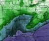
A little moist

I had to turn on the heat in the car on the way to work! ??????47 currently! Happy September
This cold front is really about to pump the brakes in Alabama late next week ain't it... Last frame looks decent on the Euro, but it still looks like it's slowing down.
Even in late summer the southeast is plagued with the stubborn SER.This is preventing cooler (not much) dryer air to move in.This looks to continue for the next two weeks.Higher dew points and temps to come aka. Muggy.

Sent from my iPhone using Tapatalk

Sent from my iPhone using Tapatalk
Round Oak Weather
Member
Well the 12z GFS is back to its warm long range look (no CAD). It keeps that big west Atlantic ridge in place and causes the I-95 corridor to swelter in tropical air. The Canadian sweeps the cold front through allowing all to feel refreshing fall air by day 10.
NBAcentel
Member
I gotta go with the GFS, that ridge off the east coast looks hard to budge
smast16
Member
^^ especially when some models show it around 6000+ M.
NoSnowATL
Member
Plus it’s only September so we have like 60 more days of summer 2.0I gotta go with the GFS, that ridge off the east coast looks hard to budge
NBAcentel
Member
This look would support major severe weather Imo 
NBAcentel
Member
When you realize that the SER has started to slowly crawl back behind our backs
NoSnowATL
Member
Just in time for winter. F#%kWhen you realize that the SER has started to slowly crawl back behind our backs
We trash the GFS but I still put it ahead of the Canadian. If the European matches the Canadian, I would then lean that way.I gotta go with the GFS, that ridge off the east coast looks hard to budge
LickWx
Member
I’ve said it before and I will say it again . Seasonal lag. Good luck getting a big cold shot east of the app mountains with those toasty 80-86 degree waters from Hatteras south to Miami . It can certainly happen but you need to really get something to push on that trough .
NBAcentel
Member
Euro is gonna disappoint some, nice 591-594 dm ridge parked over the SE
Snowflowxxl
Member
The hottest days of the year last year were in October...
smast16
Member
When you realize that the SER has started to slowly crawl back behind our backs
Started nudging its way back during Laura, but we were too distracted.
My Neighborhood pool said they would stay open through September, depending on the temperatures.
NBAcentel
Member
The euro basically looks like a repeat of last September, big 500mb heights over the SE, I’m pretty sure it would be hotter
Why
DungThe euro basically looks like a repeat of last September, big 500mb heights over the SE, I’m pretty sure it would be hotter
smast16
Member
The euro basically looks like a repeat of last September, big 500mb heights over the SE, I’m pretty sure it would be hotter

We gonna be looking like @Jimmy Hypocracy
NBAcentel
Member
Not only that but it would be quite dry
avlsnow
Member
Let’s not make it hotter please. Last September had the most days 90+ by far in the year for meThe euro basically looks like a repeat of last September, big 500mb heights over the SE, I’m pretty sure it would be hotter
Better start getting used to it. Models are in mid-winter form already. Ain't got time for the JV squad. All stars on the field already...SE Ridge, fading D10 cool shots, coastals that gradually become Apps Rubbers, evaporating CAD, you name it. Strap in, fellas, cause it's gonna be a long quote unquote winter.Not only that but it would be quite dry
NBAcentel
Member
Gotta love these type of longwave setups, either fall or swamp ass Summer, and in the winter the difference between May and deep in the freezer 
smast16
Member
Let’s not make it hotter please. Last September had the most days 90+ by far in the year for me
Hate to say it, but 12Z Euro has it 90 From Monday till the end of the run for 2/3 the state.