cd2play
Member
We're being punished.
We're being punished.
Lots of EPS members with things of interest but it seems like this year we really have not seen trends to colder on the CAD events. Everything this year has just gon the wrong way. The ones we needed to trend NW didn't and the ones we needed to hold, shifted. Or should I say shafted...CMC is a winter storm Wilkes County NC and points north-East under 150hrs. Let’s see if euro trends colder tonight. For now, I’m thinking onset ice to all rain with little to no impact.


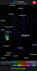
Another ridge flex signal starting to appear around d10, it’s these “squished” ridges that can produce real warm weather, especially with that system to the west meaning warm sector View attachment 37281View attachment 37282View attachment 37283
Weather talk. So nice.
Sent from my iPhone using Tapatalk
Especially with it being warm weather talk.


Currently 81*F.


That storm just went under a severe thunderstorm warning a few minutes ago. I'm wondering if whether it's going to end up coming over me but it's track has shifted from northeast to east so maybe not.


Today marks the 3rd consecutive day of 80*F+ temps.
The big difference between this year and the last 2 year is that we're finally see a normal spring transition (trees / flowers are gradually budding and blooming with roller coaster temps), versus trees in full bloom by mid/late February.
No thank you. With the covid19 and crap, severe weather is the LAST thing we need.Next week late models indicating a severe threat worth watching ... nice deep gulf moisture ahead of portent trough
No thank you. With the covid19 and crap, severe weather is the LAST thing we need.


I think low-90s are a stretch, mid-80s might be possible though.GFS brings on a legit warmup next week, temps likely will be warmer than this to since the GFS Is often to low with temps so mid 80s to low 90s would be possible View attachment 37464View attachment 37465View attachment 37466View attachment 37467