Nomanslandva
Member
A trend in the right direction, that's what I want to see.
A trend in the right direction, that's what I want to see.
yea, hugging Canada!
Just had wisdom teeth out today and it’s painful right now but at least I got something to look forward too!Germany looks a tad colder too! ???
oh man, that brings back really bad memories. Try to stay away from the hard stuff but hang in there!Just had wisdom teeth out today and it’s painful right now but at least I got something to look forward too!
Thanks!! Milkshakes have been nice so far…oh man, that brings back really bad memories. Try to stay away from the hard stuff but hang in there!


From RAH. I would be happy with just seeing snow fall:
.SHORT TERM /TONIGHT THROUGH SUNDAY NIGHT/...
As of 400 AM Saturday...
..Snow/sleet could mix with rain at times Sunday morning across the
northern Piedmont with little to no accumulations expected...
Located along the southern fringes of a prominent closed low/upper
trough crossing the Upper Midwest and Great Lakes, highly perturbed
flow will fuel strong WAA and isentropic lift across the SE US,
beginning early Sunday morning, maximized across the area during the
day Sunday, and then diminishing from west to east late Sunday
night.
A weak Miller-B low pressure system associated with these upper
impulses will track south of the area, with in-situ damming
developing across central NC.
Rain is still expected to be the dominate precip type across central
NC. However, the antecedent dry air in place across northern
Piedmont, featuring BL dewpoints in the mid lower to mid 20s, will
potentially aide to wet-bulb cool temps into the lower to mid 30s
Sunday morning, during which time forecast soundings indicate an
impressive deep iso-thermal layer, that could potentially support a
wintry mix of predominate rain mixed with snow/sleet at times during
the morning hours across the northern Piedmont. Often times, precip
rates dictate the predominate p-type in deep isothermal profiles.
Given the strongest moisture transport is forecast to remain across
southern NC, the opportunity for the sufficient precip rates could
be very limited/fleeting and thus any snow//sleet accumulations will
be difficult to come by. Other factors that will greatly limit
accumulations are BL temps remaining above freezing and occurring
during daylight hours and very late in the season, and finally very
warm ground temps in the mid/upper 40s.
9z RAP kuchera:
View attachment 134189
Yep. The earlier this precip can get in the better. We can also track how the dew points drop today. From the models, it looks like this is more of a north/south (possible) event. Meaning folks in the coastal plain have a good shot as well.MHX even talks about sleet here in the east....
as frontogenetic band develops early
in the day with column quickly saturating, and this overrunning
is expected through the rest of the day as it spreads E and N.
Sndgs indicate a period of sleet at the precip onset, as column
wet bulbs will be near 0 and a dry sub cloud layer in place
allowing for an hour or two of non-impactful PL.
As RAH discussed, too many things (warm grounds, surface temps) will stop us from seeing much accumulation. I'm at a mind set that seeing snow fall from the sky will be a win with this event. Going back to the 9z RAP, the 10:1 shows 4-5" across the Triangle area. Again not much of that would accumulate, but it would be beautiful falling.We’re not going to see this much snow on the ground at one time with this event but I’ve gone from nothing on yesterdays 6z GEFS to almost a 2” mean on the latest run

Oooh so close, just need it to hold further east lol. But yeah 12z HRRR is umm almost a big deal
DoneSomebody should start a thread
You are correct. When I saw 2.5” stick to the ground on 4/2/2019 IMBY, it stuck to and covered the fully leaved trees first… we had two Bradford pears in our front yard that literally split in half down the middle of the trunk just from having snow on them for 2 hours. Warm ground temps won’t prevent snow from piling up on trees.The biggest impact will be snow accumulating on the trees. Heavy wet snow on leafed out or fully blossomed trees could lead to a lot of problems.
TW
 wind
windI haven’t really paid much attention to this, but I’m assuming that this snowfall potential is coming from an area of strong FGEN forcing causing the column to collapse and produce a period of snow. If it is, then honestly, I would pay very little attention to the NAM as it doesn’t do well at all with those set ups. The HRRR and the RAP typically sniff those out first…2/6/2021 is a great example of that.Outside of mainly the border counties, the 12z NAM is not too enthusiastic about flakes, unfortunately.
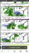
The GFS and CMC are still advertising big dog potential around day 9. A little too suppressed, but with ample cold air on today's runs. Right where we want it?

That makes some sense looking at the drought monitor. The heat ridge looks to set up from Kansas down into TX unless things change.The CFS's summer projections are interesting. Mild and wet in the east and west and warm and dry in the central areas.
Agreed… it sounds like it’s taking the shape of a typical neutral ENSO summer going into a weak El Niño in the fall.That makes some sense looking at the drought monitor. The heat ridge looks to set up from Kansas down into TX unless things change.
That makes some sense looking at the drought monitor. The heat ridge looks to set up from Kansas down into TX unless things change.
Didn't that happen last year with La Nina?
Sent from my iPhone using Tapatalk