LukeBarrette
im north of 90% of people on here so yeah
Meteorology Student
Member
2024 Supporter
2017-2023 Supporter
Euro was closeeeee
Tiny bit of noise on the EPSEuro was closeeeee
Tiny bit of noise on the EPS

Dec 9-10 redux haha
Too bad this pattern didn't show up one month earlier. We could still get lucky I guess but it'll have to be the perfect setup.Dec 9-10 redux haha
Preferrably it needs to happen at night too. Daytime snow in late March is a nightmare.Too bad this pattern didn't show up one month earlier. We could still get lucky I guess but it'll have to be the perfect setup.
Yeah, it would be devastating with all the leaves on the trees. That said, bring it in on.If that solution verified with half of the amounts, then chainsaws will be the most heard sound around these parts for a while.
Yeah, near freezing late March snow will be trouble. We need good timing and/or very cold BL temps and heavy rates, the sun this time of year is no joke. Of course, let’s just get the system first.Preferrably it needs to happen at night too. Daytime snow in late March is a nightmare.
Today's upper 50s here in Birmingham sure felt a lot warmer than upper '50s in January.Yeah, near freezing late March snow will be trouble. We need good timing and/or very cold BL temps and heavy rates, the sun this time of year is no joke. Of course, let’s just get the system first.
dynamite drop in montyToday's upper 50s here in Birmingham sure felt a lot warmer than upper '50s in January.
Wow, GFS is not backing down. And that tight gradient for the Triangle almost makes me believe it's possible.
Not a fan of this setup. Western Atlantic ridge is a big problem here, the cold vortex lifts due north which isn’t ideal, we need lower heights in the Atlantic, this could easily be a cold rain or even a apps runner/cutterWow, GFS is not backing down. And that tight gradient for the Triangle almost makes me believe it's possible.

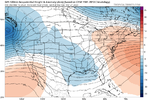
Not for everyoneEPS looks very poor. This looks like a mountain event at best View attachment 134296
But having the GFS model as the only model showing something and really bad probs from the gefs isn’t encouraging either, we’ve seen what that results in all winter long, are average high temp around this time is approaching the mid 60s, we need good looks as much as possible whether that’s a big signal on ensembles especially the EPS. It’s not encouraging that the ens that had a 4 inch snow mean here a couple weeks ago for a mountain ULL is currently the best look and even it’s bleak.Any ensemble snow mean isn't going to be bonkers 7/8 days out in late march. Even showing 1 inch mean is impressive considering the time of year.
Yea, I mean it's a long shot. But a long shot is about all you can ask for 7 days out in late March. At least there is that potential(however low) for a big dog.But having the GFS model as the only model showing something and really bad probs from the gefs isn’t encouraging either, we’ve seen what that results in all winter long, are average high temp around this time is approaching the mid 60s, we need good looks as much as possible whether that’s a big signal on ensembles especially the EPS. It’s not encouraging that the ens that had a 4 inch snow mean here a couple weeks ago for a mountain ULL is currently the best look and even it’s bleak.
Not looking like soccer practice is going to be any better this week.Soccer practice sucked last night, windy and cold.
Who forgot to pay the heating bill?
Damn I just checked the 06z GFS
Don’t get too excited for now. Little model support for anything wintry. Cold air is meager and track has to be perfect to maximize cold air that’s left. All in all not a good recipe for something magical to happen outside of the mountains. Certainly something to keep an eye on but more than likely we’re dealing with a cold rain set up.
I think he’s sitting pretty good in Erwin.Don’t get too excited for now. Little model support for anything wintry. Cold air is meager and track has to be perfect to maximize cold air that’s left. All in all not a good recipe for something magical to happen outside of the mountains. Certainly something to keep an eye on but more than likely we’re dealing with a cold rain set up.
