iGRXY
Member
The 200 hr GFS OP not moving me lolThat didn’t take long at all View attachment 133946
The 200 hr GFS OP not moving me lolThat didn’t take long at all View attachment 133946
That didn’t take long at all View attachment 133946
Looks to me like it’s slowly trending to the EPS, and it probably will, this pattern coming up favors amplification, and the euro/EPS have been steady with a more amped/slower solution, these colder air-masses are harder to move and typically drag
It’s pretty clear as day that the SE ridge will win out in this next threat. The NE weenies are not sold yet.Looks to me like it’s slowly trending to the EPS, and it probably will, this pattern coming up favors amplification, and the euro/EPS have been steady with a more amped/slower solution, these colder air-masses are harder to move and typically drag
Looks juicyView attachment 133959
Fire that severe thread up ?
Looks to me like it’s slowly trending to the EPS, and it probably will, this pattern coming up favors amplification, and the euro/EPS have been steady with a more amped/slower solution, these colder air-masses are harder to move and typically drag


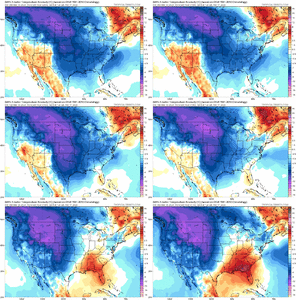
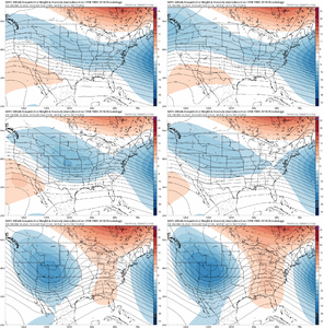
Classic example here. Big changes on the gefs which I alluded to last night View attachment 133964View attachment 133965
Delay, really no stopping it from moving east when all set and done, but the more we slow it, the more likely we shorten the cold patternDoesn’t make sense with MJO and neutral PNA -NAO. It’s just a delay I would imagine. Or it illustrates that the whole thing is broken.
Sent from my iPhone using Tapatalk
The more likely it is to shorten things, but I will say that with a MJO high amp phase 8 moving into phase one and a strongly -AO/-NAO combination, I think it’s likely that we’ll see at least below average temperatures set up for a couple weeks with some quite significant cold shots in there. I kinda thought yesterday morning that the GFS suite was rushing things a bit. The EPS/Euro has really stayed very consistent on the timingDelay, really no stopping it from moving east when all set and done, but the more we slow it, the more likely we shorten the cold pattern
It was crazy windy here last night, too. All kinds of stuff was blowing around (umbrellas and other debris).74 mph wind gusts in White House today. Went on for hours and was definitely the most insane wind I’ve seen due to how long it went on. My fence plus neighbors fences didn’t stand a chance. Nor did the trees.
View attachment 133951View attachment 133952View attachment 133953View attachment 133954
the 06z gfs had us at 34 with wintry precip at 06z around hour 360......fantasy land yes i know. The 12z gfs has us at 66 at the same timeframe. Thats only a 30 degree temp difference run to run?The Canadian is a total joke. Absurd run to run fluctuations.
Sent from my iPhone using Tapatalk


Please use the report button for those types of posts.could we keep political twitter posts out of the March discussion thread please
Did I miss something?could we keep political twitter posts out of the March discussion thread please
I guess we both didDid I miss something?
white house got hit pretty hard. Trees down everywhere and power went out for hours until last night around 8pm. I was attempting to put the fence back up because of my dogs but it was hopeless and I’m lucky I didn’t get hurt. I started hearing snapping from the trees behind me and decided to just go inside.It was crazy windy here last night, too. All kinds of stuff was blowing around (umbrellas and other debris).
That looks good. I know Topsail didn’t seem to recover the way their beach use to look, but it’s still there and homes are all over the place. Cherry Grove and North Myrtle are my typical beach destinations.Nice day on the coast, surfside beach pier finally going to be complete in May. Been down since hurricane Matthew. Rebuilding in concrete this time.
View attachment 133969
It actually makes it worse bc it just gives more time for stuff to bud out before the hammer drops.On the positive side of things, this delay in the pattern potentially helps in terms of agricultural risks. The coldest the GEFS gets us is 32°. A bullet dodged.
Sent from my iPhone using Tapatalk
It actually makes it worse bc it just gives more time for stuff to bud out before the hammer drops.
My redbud and flowering cherry are both blooming, forsythia is finishe’d.On the positive side of things, this delay in the pattern potentially helps in terms of agricultural risks. The coldest the GEFS gets us is 32°. A bullet dodged.
Sent from my iPhone using Tapatalk
