Below 900MB approaching S FL

Lol oh okThanks, I was talking about the 00z ukmet I wanted to see if it shifted east!!

Yes you have more South Carolina Members right?00z GEFS with a slight east shift but same general idea.
Sent from my SM-J320VPP using Tapatalk
If it somehow misses FL it's going to be another long week of tracking this thing to GA or SC.00z GEFS with a slight east shift but same general idea.
Sent from my SM-J320VPP using Tapatalk
A few more vs the previous run yesYes you have more South Carolina Members right?


little westHWRF 00Z Straight up FL peninsula
If Euro shifts east a little we will have a long day tomorrow!!GEFS says "not so fast, South Carolina coast."
This thing is annoying. Both ensemble paths mean a big difference for FL and SC/GA.
I wouldn't say we are seeing huge jumps outside of the wonky NAM these wobbles are probably more of just fine details then on-going shift trends
at 72 looks like it came in around Naples maybe?
Looks like 12z run? Maybe a smidge west?Euro really spares Miami the worst
923 mb landfall near Naples around Noon Sunday
We could get Severe wx from that recent Euro track here in Cae??Looks like 12z run? Maybe a smidge west?

ATM, things look better for us here to in the central midlands. Esp. if it takes that more westerly track the Euro is depicting. The NHC has their track a little further to the right, as you well know. Do you think Euro is a bit too far west? Also, i'm not sure about it being that close to the northern Cuba coastline. I know the Ukie agreest to a certain extent though. I know some of the other guidance of 0z came in a little more eastward. I'm not sure the NHC will shift the track at 5 AM. Although it's hard to bet against the ESP as well, when it's showing what it is as of now.Looks like the Carolina coasts really lucked out with this one.
ATM, things look better for us here to in the central midlands. Esp. if it takes that more westerly track the Euro is depicting. The NHC has their track a little further to the right, as you well know. Do you think Euro is a bit too far west? Also, i'm not sure about it being that close to the northern Cuba coastline. I know the Ukie agreest to a certain extent though. I know some of the other guidance of 0z came in a little more eastward. I'm not sure the NHC will shift the track at 5 AM. Although it's hard to bet against the ESP as well, when it's showing what it is as of now.
I believe the Euro and the EPS because it has been the best model with less forecast errors with Irma's track so far and it's obviously handling 500mb better.
The 0Z EPS actually suggests that IF there is going to be another shift for the Euro op, it would probably be westward again.
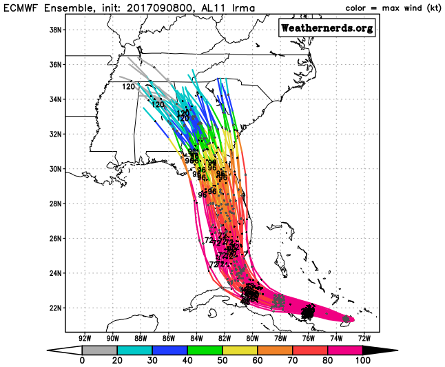
Florida is lit up like a Rainbow statewide essentially. That is one consolidated look.