Storm5
Member
If you take the icon track and the gfs surface temps western tenn and northern Miss get smoked
Sent from my iPhone using Tapatalk
Sent from my iPhone using Tapatalk
I believe the icon only shows rain or snowJust realized it’s not showing ZR or ip
Sent from my iPhone using Tapatalk

I’ll bet dollars to donuts, if the storm happened verbatim as depicted on NAM run, it’s 1” of snow, and the rest ip/zr I 85 and south! Caesars head might see 8-10”Somebody across Upstate WNC is gonna get Buried. Probably some 10-12" totals somewhere across there
Sent from my SM-A526U using Tapatalk
The benchmark for here is always jax to Savanah


My wife was looking at a FFC graph put up about the system and said the "Models" aren't showing much anymore and my weather crazed butt looked at her and said well those "graphics" aren't actually Models so may want to look at thoseThe amount of FB posts floating around out there with crazy clown totals is unreal! Never seen anything like this. But I guess in the days of social media meteorology, everything's fair game. But, one thing's certain... lots of folks are gonna get a good snow from this.
")
I'd bet dollars to donuts you're crazy ax Hell! I wasn't even speaking of the NAM, I'm speaking of this storm in General. It's clear to see someone across those areas will get buried!I’ll bet dollars to donuts, if the storm happened verbatim as depicted on NAM run, it’s 1” of snow, and the rest ip/zr I 85 and south! Caesars head might see 8-10”
Front Royal or Winchester was my early thoughts, Brevard / Boone too, but this should be a clean hook around Florence heading NNE and maturing rapidly through 40N.Not a fan of the Icon track after surface leaves savannah. The heading north needs 1 to 2 more ticks NE. It gets to wilm, then north to G vegas, NW to Rich, before correcting Due NE
Yeah but the that surface LP takes a weird track once on shore around cape lookout NC. Goes due north. If it went NE we'd have more snow.ICON manages to keep RDU below freezing the entire storm...
Ryan Maue says it's a great model
Could someone speak to the potential to see prolonged heavy sleet instead of zero from Atl metro/ i20 corridor NE?? I only ask abt this bc of the advertised CAD strength. Is this just a case of cold being far too shallow to support zr bc of the Low track?? I could be very wrong w my history but seems that climo history might be supportive. Thanks in advance!

The good storms don't care...they bring the overrunning forcing for ascent in hot and heavyI saw that. Dont need to be fighting virga during the guranteed snow time front end thump

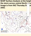
Thats a carbon copy of Dec 2002WPC's latest forecast map...looks reasonable....Miller A/B Hybrid
Kind of surprised the NAM is so warm. Warning shot for much of N GA?


Kiddo is at 4300ft, Boone. Id go up if not for work Mon and 6 inches of concrete back here to come to. Not to mention heavy frzng rn scenerio close by. Although think mby will be spared worst of that.Front Royal or Winchester was my early thoughts, Brevard / Boone too, but this should be a clean hook around Florence heading NNE and maturing rapidly through 40N.


Ideally, I think most of us (outside the mountains) would like to see it a good 50-100 miles offshore of SAV instead of right onshore like that, but yeah it’s not too bad of a look, but definitely one that would changeover most of us eventually.Wow icon is very impressive. That Low is pretty perfect for the Carolinas IMO
Sent from my iPhone using Tapatalk
Yes, that’s what I’m loving! If the NAM doesn’t kill our moisture and this cold holds serve next 24 we could be in a decent spot east of Atl for once. If that wedge is as stout as advertised I think we have a good shot at seeing more sn/ip vs the zr.Frontend snow going deeper and deeper into GA every run.


Yep, in the end, not much different....it was a little south, but had more amplitude on its eastern flankEnergy looks stronger but a touch south.

The track of the Icon is about perfect if you want 4-6” from BHM to Huntsville. The 500mb low runs right down I20.If you take the icon track and the gfs surface temps western tenn and northern Miss get smoked
Sent from my iPhone using Tapatalk