Jessy89
Member
I will never pay anyone’s winter forecast attention again. All those winter forecasts will turn out to be wrong!
Sent from my iPhone using Tapatalk
Sent from my iPhone using Tapatalk
Just got to get through Wed and Thursday this week and then we bake. Going to be great...hello spring.
View attachment 13801View attachment 13802View attachment 13803
I will never pay anyone’s winter forecast attention again. All those winter forecasts will turn out to be wrong!
Sent from my iPhone using Tapatalk

GEFS paints the bigger picture. And it’s down right uglyBefore you two start going all wambulance, it only lasts 3 days
Before you two start going all wambulance, it only lasts 3 days

This:
View attachment 13804
Usually doesn't just break down that quickly and the GFS is about to way too quickly. That pattern that I just showed usually lasts at least two weeks.
Before you two start going all wambulance, it only lasts 3 days

Yeah in March and even in late Feb there are so many issues to worry about its not even worth it. Late Feb and March you absolutely need for it to snow at night unless you get lucky enough to get some very heavy precip rates during the day. How often does light snow accumulate during the day in Late Feb/March ?And by that point we are looking at end of February. With only a week in which we could see a good snow. Very unlikely a very small needle to thread there. And in March you about need it to snow at night to stick well around here due to sun angle
Sent from my iPhone using Tapatalk
Oh no the deluge continues. It may or may not be associated but we are going back through the same MJO phases again and again so its probably likely to verify given our setup.Those are +15F temp departures.
Like I said...salt in the wound. Pouring rain can really mute those highs. This is even worse.
View attachment 13806
Yeah in March and even in late Feb there are so many issues to worry about its not even worth it. Late Feb and March you absolutely need for it to snow at night unless you get lucky enough to get some very heavy precip rates during the day. How often does light snow accumulate during the day in Late Feb/March ?
Absolutely. I saw Thunder Snow for HOURS in March 2009 and it barely accumulated. The rates were just not heavy enough. Even moderate snow wont cut it during the daytime in March. You need heavy snow unless its at night.It doesn’t I’ve seen it snow all day long in March. And it didn’t stick at all
Sent from my iPhone using Tapatalk
Yup ...All of the latest runs of the major models now have warmer than normal for the SE for both the 6-10 and 11-15 day periods.
Was worried this was going to happen. Comments after my post are ironic.
https://southernwx.com/community/threads/jammin-january.494/post-135617

Yeah and if that's the case and it seems very well so, I might as well take this event and punt the remainder of winter. It just wouldn't be favorable. If we are looking torch like, I petition to rename the thread Flambé February.Was worried this was going to happen. Comments after my post are ironic.
https://southernwx.com/community/threads/jammin-january.494/post-135617
I’ve seen this image pop up several times in the LR. I do not believe for a minute that there will be a big trough like that east of HI and then a -PNA/SE ridge combo. We will see, but that looks ridiculous to me. Allghidance has a SE ridge for then.
View attachment 13828
Meanwhile, the typically clueless CFS 0Z was quite cold with suggestions of Miller A’s and major snow threats in mid Feb! It was cold practically throughout its run. However, the 6Z CFS changed to warmth.
No, but zonal flow wouldn’t be much of a surpriseI’ve seen this image pop up several times in the LR. I do not believe for a minute that there will be a big trough like that east of HI and then a -PNA/SE ridge combo. We will see, but that looks ridiculous to me.
View attachment 13828
.png")
-EPO & a -NAO concurrently what's the worst that could happen!No way the pattern will be as bad as modeled. Pretty tough to have a -EPO and a -PNA but somehow in this hell forsaken winter we are going to do it.
View attachment 13852
-EPO & a -NAO concurrently what's the worst that could happen!
How ironic we've all been touting jan25th as a big turning point for couple weeks. Had weeklies on board and everything for a fab feb into march. But it wasnt even 48 hrs into this holy grail pattern and we are already looking for the next one. Gonna take a lucky fluke for alot of us to net a synoptic winter storm. Hopefully the post Feb 15th produces. Really do hate to see a lot of folks end up shutout. Atleast this front will help a few out. Summer is to long and painful down here without getting atleast one snowfix beforehand.
Another round of blocking. Another ? We are still waiting for the first round ... lolSo, as I look at the overnight medium to long range guidance I can't help but be somewhat optimistic for mid-February. It appears as if we only get a brief warm-up before another round of blocking commences--and this time we may in fact get a return of the previously active southern stream to join in with the fun. Time will tell of course, but no reason to throw in the towel just yet, in my opinion.
Week 3 of the weeklies which takes us thru Feb 20 is trending a lot warmer apparently. Hopefully this doesn't come to fruition
Yeah but the deep red makes it more dramatic. Good catch @Jon#TemperatureScalesMatter
If he used the same one in the left image it wouldn’t be as drastic
The yellows would be orange
Brown (normal) would be yellow
And the light blue would be brown
A little warm but only 1-2F+ for the SE
Sent from my iPhone using Tapatalk

I think this is the model that GaWx was speaking on, when he said it spit out the best winter pattern he has ever seen, then 6 hours later, not so much
I think this is the model that GaWx was speaking on, when he said it spit out the best winter pattern he has ever seen, then 6 hours later, not so much

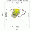
MJO: Both the GEFS and EPS are projecting a pretty lengthy period in phase 7, but the amplitudes are way different. GEFS is very strong and exceeds 3 while EPS is weak and near 1 (right on circle):