In the 2 inch mark no doubt. Will see tommorow how it shakes out. Had lightening between 10-11 tonight.
-
Hello, please take a minute to check out our awesome content, contributed by the wonderful members of our community. We hope you'll add your own thoughts and opinions by making a free account!
You are using an out of date browser. It may not display this or other websites correctly.
You should upgrade or use an alternative browser.
You should upgrade or use an alternative browser.
Pattern November 2023
- Thread starter packfan98
- Start date
.25” for the event which gives me .43” for November following .32” for October. I had 1.4” for September. My last rain over .75” was August 29th. Flash drought is a real thing.
W
WSW
Guest
2.15 at IAD.
- Joined
- Jan 23, 2021
- Messages
- 4,604
- Reaction score
- 15,202
- Location
- Lebanon Township, Durham County NC
-------- mentioned that Charlotte got more rain yesterday than in the previous combined eighty days.
Thought we were doing better than we were today is the first rain of more than a T or .01 in 30 days and more than we have had combined since ophelia about 60 days ago. 1.76 so far with maybe another .1-.15 to go-------- mentioned that Charlotte got more rain yesterday than in the previous combined eighty days.
Cary_Snow95
Member
2.18” so far in Cary. Much needed
I ended up with .7” thanks to the last minute line that formed. 1.5” for the month..25” for the event which gives me .43” for November following .32” for October. I had 1.4” for September. My last rain over .75” was August 29th. Flash drought is a real thing.
2.55" and counting. Been a long time.
W
WSW
Guest
Really glad so many people did well. Let's make the next one snow, though.")
I got 2.70 inches here near Lake Wheeler in Wake County. This system was an overperformer and if this any indication of how El Nino is going to bring the goods, I am in store for a wet and if the cold air will cooperate, snowy winter. If this had been a snow event it would have been epic.
This horrible dry slot continues for the next 7-10 days. fml

NoSnowATL
Member

That supposed to be helpful?
It says from Nov6 through Dec6, we are already at Nov 22 and my specific area has a little over 1" rain for the last month. As I just posted, we expect no rain for the next 10 days. Everyone knows hr 240+, esp out towards 300+ isn't super reliable for predicting anything.
We are also still very much in D2 Severe Drought.

NoSnowATL
Member
No that's the latest run starting today, just goes out to 384 not 270. We def need more rain and we will in the coming weeks.That supposed to be helpful?
It says from Nov6 through Dec6, we are already at Nov 22 and my specific area has a little over 1" rain for the last month. As I just posted, we expect no rain for the next 10 days. Everyone knows hr 240+, esp out towards 300+ isn't super reliable for predicting anything.
We are also still very much in D2 Severe Drought.
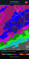
View attachment 138100
Here's GFS 6z from 6 to 312, which shows zero rain in our area:No that's the latest run starting today, just goes out to 384 not 270. We def need more rain and we will in the coming weeks.

And here's further out into fantasy land on the same run.
Everybody here knows how useless GFS is in this time range. I've seen rain like this in the 300+ hr range on GFS pretty regularly over the past month and precious little came to fruition. Why should it be different now?

Over-performed here in Greenville, model consensus heading in was somewhere around 1.5”

Shaggy
Member
Just got around 2 inches in the last hour and had over an inch already when thisnlast dump of rain started.2.55" and counting. Been a long time.
Attachments
Drscottsmith
Member
Just had pea sized hail in a shower here in Duncan.
Drscottsmith
Member
Just had pea sized hail in a shower here in Duncan.
Handful of hail/graupel producers out there today
- Joined
- Jan 23, 2021
- Messages
- 4,604
- Reaction score
- 15,202
- Location
- Lebanon Township, Durham County NC
Friend of mine just reported a pretty decent hail shower on the Buster Boyd Bridge on Highway 49 at the NC/SC line.
NBAcentel
Member
Pretty legit -NAO trend for early dec. 
Brent
Member
Still watching Saturday night here... Gonna be a very close call
The best precipitation chances
(50-70%) will occur Saturday evening and through the overnight
hours. There remains a potential of light rain mixing in with
light snow along the OK/KS border late Saturday night into Sunday
morning, specifically for northwestern portions of Osage and
Pawnee Counties. Travel impacts are still not anticipated at this
time with little to no snow accumulation forecast. As the previous
forecast discussion mentioned, the forecast will continue to be
refined as the event draws closer.
Have some flurries falling in Blowing Rock, at least at my elevation. Was hoping some would appear with how cold its gotten here today.
That’ll play

JHS
Member
That will not bring snow though since we will not be getting any precip with it. It may as well be warm. 80 degrees would be nice for a few days.That’ll play
View attachment 138108
How much rain in jonesvegas last night?That will not bring snow though since we will not be getting any precip with it. It may as well be warm. 80 degrees would be nice for a few days.
Where did the energy come from this afternoon? Was riding on the ambulance and the rain in eastern Union (NC) Monroe, Wingate area, was not expected along with the thunder/lightning. Last I looked , last night , the rain was supposed to be gone by late morning.
JHS
Member
We got 1.90 last night because the line slowed down over our area. The 18z GFS is fairly dry through day 10 and stays that way for most of the Carolinas and GA through hour 384, with a couple of pockets of .75 plus totals so it is a good thing much of NC and SC got good rain yesterday. West of the mountains does better with up to 2 inches out there, still after day 10 through so we will see what happens.How much rain in jonesvegas last night?
Shaggy
Member
Solid over performer here today. Totaled 3.4 for the day
Ron Burgundy
Member
So sorry about the 1.90” of rain. T’s & P’s.We got 1.90 last night because the line slowed down over our area. The 18z GFS is fairly dry through day 10 and stays that way for most of the Carolinas and GA through hour 384, with a couple of pockets of .75 plus totals so it is a good thing much of NC and SC got good rain yesterday. West of the mountains does better with up to 2 inches out there, still after day 10 through so we will see what happens.
Nomanslandva
Member
Happy TG Southernwx peeps. late to post but we totaled 2.1 here with the much needed rain. It looked like west salem might have even seen some flakes late yesterday evening.
And back to our regularly scheduled programming…

WXinCanton
Member
38 this morning, happy Thanksgiving!
W
WSW
Guest
At least the last week of November looks nice and cool.
This seems rather chilly.

tennessee storm
Member
384 hours ?
597DM
Member
Based off what. December looks warm
384 hours ?
??
Drizzle Snizzle
Member
I think we need a December thread.
BHS1975
Member
I think we need a December thread.
Diablo December?
Sent from my iPhone using Tapatalk