NoSnowATL
Member
GFS always does, she will fold to the Euro like the NAM did. That’s the reason most Mets favor the E over Goofy.LP track was further S & E, which may have been a slight nod to the NAM, but it did appear to struggle with the CAD
GFS always does, she will fold to the Euro like the NAM did. That’s the reason most Mets favor the E over Goofy.LP track was further S & E, which may have been a slight nod to the NAM, but it did appear to struggle with the CAD
Wow - that’s a 4” to 5” mean over city of ATL (ITP)!12Z GEFS mean huge jump
Ends up pushing into south central PA; switching DC up to Boston over to rain. We saw outputs like this yesterday. I guess it's a possible outcome at this point.This sucks

Personally I don’t. Like I posted earlier, in most Miller As, the are of significant ice build up is in a band so much more narrow than what these ZR maps show. Right now looking at the soundings I would expect southern Mecklenburg over to Union County to get a decent front end thump of snow, a quick couple inches or so with a FGEN band, and then go over to a sleet/snow mix then mostly sleet with some ZR at times. Like I said the sleet could really be heavy perhaps being similar to February 2014 when this area saw 2-3” of sleet after the initial snow. After this we will see if any of the backside deform band swings throughI'm in ballantyne, and I'm sure my weather will be similar to yours.. do you think we're going to have crippling freezing rain?

Indeed, though I feel pretty confident a surface low track west of I-95 has a very low chance of happening. I can’t think of a single instance of that ever happening in the face of CAD.This sucks
That’s a difference of what… 450 miles or so in 24 hours, 2 runs? Obviously there is a clear trend here. Both operationals and ensembles are beginning to cluster now to a solution on the track. Between I-95 and the coastline… I think it will ultimately end up closer to the coast line than 9512z canadian yesterday vs today. dont get caught up in specifics just have to hope these trends continue.

Note "conservative"


Odds are they are moving the high out too fast. Globals erode CAD much faster than reality.At what point isn't this really a CAD situation dictating LP track. The high is weak and moving out. LP is too strong for in situ except right up against the mountains.
1993 superstorm had a bit of a nosing HP preceding it too which it overcame like a knife through butter as the low tracked right up through the Triangle.

Models are showing a lot more than that and that is with no FGEN. That is low compared to what we have seen. Climo also says colder temps with CAD and longer duration. I am definitely willing to bet we see this likely increase. Especially in the mountains.
1993 Superstorm was way more intense....the pressure was already in the low 970s around the GA/SC border.At what point is this not really a CAD situation dictating LP track though? The high is weak and moving out. LP is too strong for in situ except right up against the mountains.
1993 superstorm had a bit of a nosing HP preceding it too which it overcame like a knife through butter as the low tracked right up through the Triangle.
This is much closer to a classic CAD than in situ.At what point is this not really a CAD situation dictating LP track though? The high is weak and moving out. LP is too strong for in situ except right up against the mountains.
1993 superstorm had a bit of a nosing HP preceding it too which it overcame like a knife through butter as the low tracked right up through the Triangle.
Was there a snow map?This is from the 06z Euro, but the mid level flow running orthogonal into the Blue Ridge side of the mountains is going to be tremendous here....intense mtn precip
Yes and that storm was as perfectly stacked vertically as a land based cyclone can be..1993 Superstorm was way more intense....the pressure was already in the low 970s around the GA/SC border.
View attachment 105002
Good to see the 12z UK In the gulf. Second run in a row.
GFS:Which model is showing that while calculating sleet at the same time. I’m not complaining. I understand the conservative move, why we start out like that. But we have WNC having more models with more measurable snow. Perhaps even coming g into the upstate to Easley - Lyman. That is how our climate is. This notion that CAD will be stronger with a weaker high.
Sent from my iPhone using Tapatalk


That’s interesting and it makes a lot of sense as there would be a natural baroclinic zone for the low to move along. This is something to watch in future NAM runs and the HRRR.I think most of the models are starting to agree that the low is going to dig well and we're getting away from the Miller B scenario into more of a hybrid A/B. That is great great great. The challenge seems to me to be where does it transfer to our SE. We need it on the coast to keep mixing away, and to let our folks in the east in the game later. The whole ramming up I-95 inland is just the worst.
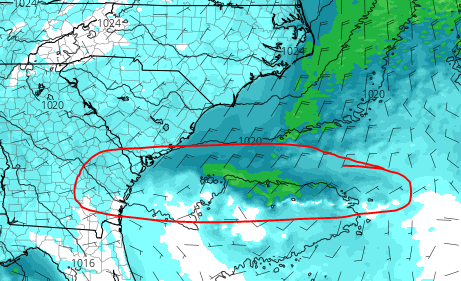
ILMRoss on American made a nice observation about the transfer likely being along the ribbon of low level vorticity that forms off the coast along the wedge front. He noted it below on the Nam 3K. Convective models show it, others are not. His expectation would be I believe the transfer happens on the coast in this area. That would be huge if correct.


The energy looked great thru hrs 60 -72...then the low cuts up 85 around the KIA plant exit drawing the warm air up. I don't have access to surface precip maps for the UKMET, but I'm guessing that adjustment @78 allows more warm air to advect north.UKMET was warmer for ATL
This is a really good map and I think matches up well with what we're seeing.Call map from a good poster ~ Eyewall
At the other place. Looks pretty goodView attachment 105010
I just realized where I had seen something like that before. This is exactly what happened with the January 1996 storm. I remember reading it in a storm summary once. Even 12-18 hours before the storm started in the Carolinas, guidance was wanting to form the coastal on the coast which would have meant much less wintry precip for Central NC. Instead it formed a bit further out along a vorticity ribbon like that and it allowed much colder air to be locked in for the duration of the storm. The whole corridor from CLT metro up to the Triangle had a massive sleet storm during that with temperatures in the low 20s… some areas had as much as 4-6 inches of sleetI think most of the models are starting to agree that the low is going to dig well and we're getting away from the Miller B scenario into more of a hybrid A/B. That is great great great. The challenge seems to me to be where does it transfer to our SE. We need it on the coast to keep mixing away, and to let our folks in the east in the game later. The whole ramming up I-95 inland is just the worst.
ILMRoss on American made a nice observation about the transfer likely being along the ribbon of low level vorticity that forms off the coast along the wedge front. He noted it below on the Nam 3K. Convective models show it, others are not. His expectation would be I believe the transfer happens on the coast in this area. That would be huge if correct.
That leads me to believe that our area will be spared from any rain mixing hence the cold temps which would signify snow/IP/ZR on the ground. (probably not a good thing though) I think we see it all here. What I a most concerned and hopeful about is that we see a sig amount of ZR on top of snow both on the front and backend. Travel is going to be treacherous, to say the least. Further east is where the bigger question remains. If that SL transfers further south towards Savannah, it's most likely going to keep the Trianagle all frozen and up snow/ice totals as well.The temps the GFS shows the night after would be the coldest since Jan 2018 View attachment 105009
Great post here. I'll add to remember climo. Regardless of our setup, track adjustments, or last minute tricks, climo says 90% of the time that last paragraph is what is going to happen with these type systems. Mtns and higher peidmont areas will get a big dog snow, adjacent areas are going to mix, and areas outside that are going to have a lot of ice and slop. We're all pulling for our backyards and some of us will see last minute adjustments that will make a big difference one way or another but climo should tell us a lot.As is typical, super CADs at 144 "weaken" as we move in because confluence moves out earlier or appears weaker the closer we get. Why? No -NAO. There are exceptions to this, but you can usually count on it.
I think we know what we have now. I'm doubtful of any meaningful changes to the track. It's not going to shift wildly offshore. No more new data ingests are going to save the day.
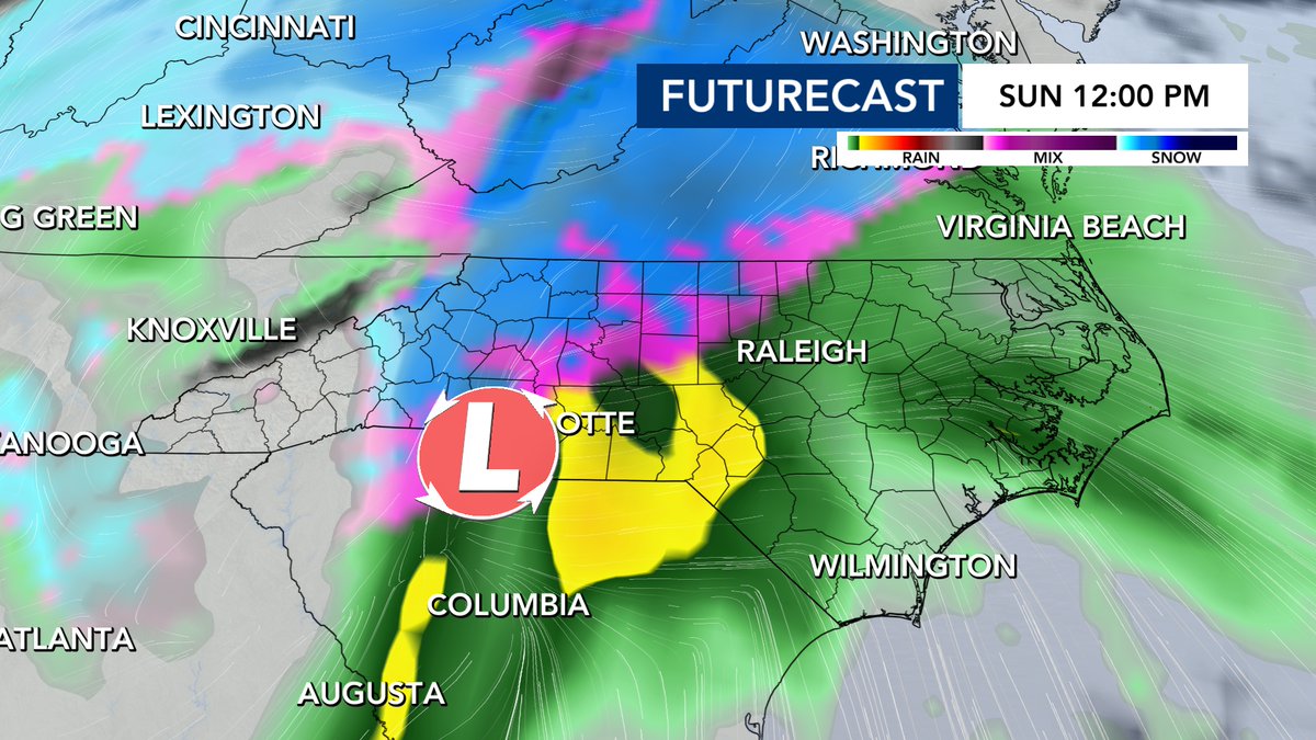
Northern parts of AL, GA, much of TN, the western half of SC, up through the mountains of NC into the Piedmont/Triad region, and the western half of VA are going to get a significant winter storm. There will be mixing issues for many of those areas. East of there, including the Triangle, and central VA, it will be a burst of snow or sleet, quickly changing to ZR then to rain...which is preferable to me over an ice storm. The drought monitor continues to take a hit, and that is good.