Stephenb888
Member
Lol a dusting to an inch in Anderson ok. Amazing how all the ingredients are in place and this is all we have to show for it.
Lol a dusting to an inch in Anderson ok. Amazing how all the ingredients are in place and this is all we have to show for it.


Lol a dusting to an inch in Anderson ok
That actually is really bold for first call maps from any mets. They usually start low and work up.
Family is heading to Pigeon Forge, but with things all over the place we would probably do just as good staying in North/Central Alabama. PF looks to be in the warm slot on most models.Making plans to head to Beech/Avery county to chase -- where are people heading to chase?
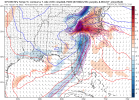
LP track was further S & E, which may have been a slight nod to the NAM, but it did appear to struggle with the CADThe GFS still seems to be struggling with the CAD. When FFC is even saying that it's more likely a stronger CAD is possible in their AFD then it is either evident that it is underdoing the CAD or we're in for a really cold rain. I lean more toward the GFS failing at CAD. More important to focus on its track I'd say.
I know but I just thought this was “one of strongest CAD we’ve seen in a while” and now it doesn’t look like it.His projection is pretty good at this time. Climate suggests this.
Sent from my iPhone using Tapatalk
I am just north of CLT in Huntersville. Looks to be a lot of IP or ZR around me based on the track and some soundings. Concerned for sure about losing power. If we can get that low to track a little further south or east it might change us to some more snow.I’m leaning towards us staying below freezing for the duration, possibly the upper 20s, but from what I’m seeing on these soundings, I really think that after that front end thump of snow, we’re gonna see sleet dominate with some ZR until whatever snow the backside brings. I wouldn’t be at all suprised at all if the corridor from eastern CLT metro up to the west side of the triangle has a solid concrete glacier on the ground by Sunday evening
Ensembles continue to show a lot more snow in the upstate and piedmont for the duration of the event with more ice down around the midlandsThru 72 I'd say once again the ensembles overall have a colder look, with more frozen precip (edit: colder than the Op still not the best track for central NC)
That actually is really bold for first call maps from any mets. They usually start low and work up.
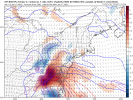
Hush!!!! Lol hopefully the nam trends continue and can keep that warm nose at bay. We might make a run for it. I'm sweating bullets.If someone in this area can find a way to stay all or mostly snow there’s going to be some big boy totals. Keep seeing lollipops in this area. NAM was concerning with temp profiles but from what I can remember in the past it’s a little amp happy towards the end of its range. View attachment 104985
I honestly don't put a lot of stock into what the GFS says in this range. Especially, when it comes to the clown maps and soundings. They are always way overhyped and hardly ever come to fruition. Can't count on both hands how often they are wrong than right. I also have a hard time believing that Nashville ends up with a foot of snow while some of the sweet spots in NC end up with half that, especially during a CAD event like this. I am much more into short-range modeling at this juncture. Just my two cents though.The GFS still seems to be struggling with the CAD. When FFC is even saying that it's more likely a stronger CAD is possible in their AFD then it is either evident that it is underdoing the CAD or we're in for a really cold rain. I lean more toward the GFS failing at CAD. More important to focus on its track I'd say.
Thru 72 I'd say once again the ensembles overall have a colder look, with more frozen precip (edit: colder than the Op still not the best track for central NC)
Models are showing a lot more than that and that is with no FGEN. That is low compared to what we have seen. Climo also says colder temps with CAD and longer duration. I am definitely willing to bet we see this likely increase. Especially in the mountains.I disagree. Climatology speaking he is on point.
Sent from my iPhone using Tapatalk
Me too, man. I don’t want one grain of sleet. It’s close!Hush!!!! Lol hopefully the nam trends continue and can keep that warm nose at bay. We might make a run for it. I'm sweating bullets.
I know but I just thought this was “one of strongest CAD we’ve seen in a while” and now it doesn’t look like it.

Thru 72 I'd say once again the ensembles overall have a colder look, with more frozen precip (edit: colder than the Op still not the best track for central NC)

I’m just saying this based on typical Miller A climo, since that’s what the clear trend is.… I really don’t think you’re going to have a huge ice accrual up you way. Some ZR mixed in at times yes, but nothing to cause widespread damage. Typically the area of major ZR in a Miller A in the Carolinas is in a much more narrow area than what is being depicted on these ZR accumulation maps, and I see that setting up close to the Hwy 1 corridor . You typically will see a much wider area of sleet dominate, and there can be a lot of it.I am just north of CLT in Huntersville. Looks to be a lot of IP or ZR around me based on the track and some soundings. Concerned for sure about losing power. If we can get that low to track a little further south or east it might change us to some more snow.
I've had ensembles all show me over 8 inches 24 hours before an event. I got a trace.I was burned by the GEFS back in Jan 2016 so I don't know....most of those panels look amazing for my backyard, but I'm always going to be suspect of GFS ensemble members.

Me too, man. I don’t want one grain of sleet. It’s close!
I'm in ballantyne, and I'm sure my weather will be similar to yours.. do you think we're going to have crippling freezing rain?I’m just saying this based on typical Miller A climo, since that’s what the clear trend is.… I really don’t think you’re going to have a huge ice accrual up you way. Some ZR mixed in at times yes, but nothing to cause widespread damage. Typically the area of major ZR in a Miller A in the Carolinas is in a much more narrow area than what is being depicted on these ZR accumulation maps, and I see that setting up close to the Hwy 1 corridor . You typically will see a much wider area of sleet dominate, and there can be a lot of it.

If someone in this area can find a way to stay all or mostly snow there’s going to be some big boy totals. Keep seeing lollipops in this area. NAM was concerning with temp profiles but from what I can remember in the past it’s a little amp happy towards the end of its range. View attachment 104985
Backside SN rates looking stout as well. That’s the part I’m most curious about. So hard to trust a backside def band holding together into our area but when they do - look out.Welp according to the CMC, my backyard now starts off as snow(probably sleet mixing in too)...here we go.