Awesome! If his forecast is opposite of what happens like his forecast was last year, we are sitting great!
-
Hello, please take a minute to check out our awesome content, contributed by the wonderful members of our community. We hope you'll add your own thoughts and opinions by making a free account!
You are using an out of date browser. It may not display this or other websites correctly.
You should upgrade or use an alternative browser.
You should upgrade or use an alternative browser.
Wintry Winter 2019-20 Discussion
- Thread starter Snowfan
- Start date
Cad Wedge NC
Member
Yep, we are looking good.Awesome! If his forecast is opposite of what happens like his forecast was last year, we are sitting great!
This is old, but appropriate
tennessee storm
Member
Like the tornado ? part lol....This is old, but appropriate
Isotherm's winter outlook is now up: http://www.lightinthestorm.com/
Hint: Mods, delete my post before someone clicks the link and jumps out the window.
LOL...well this guy is really good so that's scary he came up with this. That has to be the warmest winter pattern for the SE. With the consensus looking like Dec will torch we will have to wait until mid-January to really know if we will have any chance at a good back half.
tennessee storm
Member
Yes. He is very good what he does .. I put a lot faith in his cast ... hopefully he is correct part me wants it to Be correct. At least ...LOL...well this guy is really good so that's scary he came up with this. That has to be the warmest winter pattern for the SE. With the consensus looking like Dec will torch we will have to wait until mid-January to really know if we will have any chance at a good back half.
NoSnowATL
Member
LOL...well this guy is really good so that's scary he came up with this. That has to be the warmest winter pattern for the SE. With the consensus looking like Dec will torch we will have to wait until mid-January to really know if we will have any chance at a good back half.
As stated earlier he was way off last year. I do agree December will be warmer then avg and January will be as well for the first half. I think February and March will be our only hope to not repeat last year.
Sent from my iPhone using Tapatalk
As stated earlier he was way off last year. I do agree December will be warmer then avg and January will be as well for the first half. I think February and March will be our only hope to not repeat last year.
Sent from my iPhone using Tapatalk
It seems though when winter forecasts are wrong they are wrong when calling for snowy/cold in the east. When was the last winter where the consensus was for a AN winter in the east and it ended up being BN. Winter of 2015 was called fairly well, back half weak nino. 2014 was called pretty well too, if I recall. Then you have to go all the way back to 2010 and 2011 for the previous BN winters in the E/SE. I know 2010 was called cold/snowy by most.
It seems though when winter forecasts are wrong they are wrong when calling for snowy/cold in the east. When was the last winter where the consensus was for a AN winter in the east and it ended up being BN. Winter of 2015 was called fairly well, back half weak nino. 2014 was called pretty well too, if I recall. Then you have to go all the way back to 2010 and 2011 for the previous BN winters in the E/SE. I know 2010 was called cold/snowy by most.
I may be wrong, but I remember most calling for torch city the 2013-2014 winter.
I'm not sure any of it relates to the skill of any particular long range forecaster. I mean look at the map I did earlier. I didn't use a bunch of elite meteorological terms or fancy analogue sets or any collegiate scrabble words or anything, and I'm probably going to be right. Not taking anything away from Isotherm's (or anyone else's efforts), but going with warm winter persistence, while sort of a cop-out forecast, is likely to turn out accurate. Going colder takes some grapefruits, because most of the time (especially these days) you're just going to flat out be wrong.It seems though when winter forecasts are wrong they are wrong when calling for snowy/cold in the east. When was the last winter where the consensus was for a AN winter in the east and it ended up being BN. Winter of 2015 was called fairly well, back half weak nino. 2014 was called pretty well too, if I recall. Then you have to go all the way back to 2010 and 2011 for the previous BN winters in the E/SE. I know 2010 was called cold/snowy by most.
I may be wrong, but I remember most calling for torch city the 2013-2014 winter.
Isotherm's analog package was pretty good for that winter. I can't recall many that were blowtorch warm.
I'm not sure any of it relates to the skill of any particular long range forecaster. I mean look at the map I did earlier. I didn't use a bunch of elite meteorological terms or fancy analogue sets or any collegiate scrabble words or anything, and I'm probably going to be right. Not taking anything away from Isotherm's (or anyone else's efforts), but going with warm winter persistence, while sort of a cop-out forecast, is likely to turn out accurate. Going colder takes some grapefruits, because most of the time (especially these days) you're just going to flat out be wrong.
Agreed...6 out of past 8 were AN. You go AN every winter you will be right 75% of the time, which is pretty good. I do think we will have a BN winter coming up soon...in the next decade, I hope.
I'm really hoping the low solar component throws a monkey into the wrench that ends up confounding the warm forecasts.Agreed...6 out of past 8 were AN. You go AN every winter you will be right 75% of the time, which is pretty good. I do think we will have a BN winter coming up soon...in the next decade, I hope.
Isotherm's analog package was pretty good for that winter. I can't recall many that were blowtorch warm.
I would say his forecast was decent at best. His snowfall forecast busted bigly as Trump would say across the SE.
I'm really hoping the low solar component throws a monkey into the wrench that ends up confounding the warm forecasts.
This to me is a good sign, Nov with this stout an Aleutian low. 2015, 2010, 2003.
Very different than 2019, 2007, 2005
But it seems like every winter we develop this false hope and it never materializes.

Thanks for posting that. I've noticed the Aleutian Low showing up a lot lately as well. Now, the latest model runs essentially go to pot in D10+ range wrt to the Aleutian Low and in the polar regions. I suspect we'll know in 2 or 3 weeks whether or not the AL will be a recurring feature of Winter 2019-2020.This to me is a good sign, Nov with this stout an Aleutian low. 2015, 2010, 2003.
Very different than 2019, 2007, 2005
But it seems like every winter we develop this false hope and it never materializes.
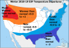
View attachment 25587

NBAcentel
Member
Early December storm ?! Lolol
Itd be nice to find a way to get that into the Greenland/davis strait region and go full blown -nao
Sent from my SM-G975U using Tapatalk
NoSnowATL
Member

He will push for cold until he is 6ft under. You have to respect that in a way.
Sent from my iPhone using Tapatalk
Dump all the cold air in Europe ?

Webberweather53
Meteorologist
This pattern is going to put a lot of pressure on the stratospheric polar vortex, if we can keep it going for more than a few weeks, things could get interesting down the road.
Downeastnc
Member
This pattern is going to put a lot of pressure on the stratospheric polar vortex, if we can keep it going for more than a few weeks, things could get interesting down the road.
#3 on my personal best list for MBY was the Dec 2-3 2000 snow, I had 15" on the roof of my car the next morning.....officially we had 8-10" but I measured 12-15" on many flat open spaces. Only Feb 1989 and Mar 1980 had deeper totals.....
Fab Feb incoming!

I really hate this model.
I really hate this model.
Webberweather53
Meteorologist
Itd be nice to find a way to get that into the Greenland/davis strait region and go full blown -nao
Sent from my SM-G975U using Tapatalk
That's usually how we get -NAO regimes & if that Scandinavian block verifies much stronger than currently forecast, we'll be in business
Webberweather53
Meteorologist
Fwiw...

It is worth nothing.
packfan98
Moderator
Here's a link to the entire forecast and video. He basically is citing the neutral enso state for going with above normal temperatures, and precip.
Brad P's Winter Forecast
I don’t understand where he gets “above normal” temps with an Nominal ENSO you have the same equal chance of below temps as well.
Sent from my iPhone using Tapatalk
Sent from my iPhone using Tapatalk
Webberweather53
Meteorologist
This year definitely leans nino even though we haven’t met “x” sst threshold in the Pacific. A nino winter favors above average snow in the mountains, far western and northern piedmont, basically from Roxboro-Greensboro-Statesville and points NW, with nearly equal chances of above or below further SE. Usually a safe call to bank on a big seasonal gradient across the piedmont in a winter like thisHere's a link to the entire forecast and video. He basically is citing the neutral enso state for going with above normal temperatures, and precip.
Brad P's Winter Forecast
I can’t believe B Rad is going Below normal! He’s the BRad P of -----’s! I’m going to go with the middle of his prediction and JBs, for my official forecast! 150% of normal @ GSP! You heard it here first! 6” or bust!
packfan98
Moderator
Brad went above normal.I can’t believe B Rad is going Below normal! He’s the BRad P of -----’s! I’m going to go with the middle of his prediction and JBs, for my official forecast! 150% of normal @ GSP! You heard it here first! 6” or bust!
I meant temps, BNBrad went above normal.
packfan98
Moderator
He went above normal on temps too.I meant temps, BN
That’s more like him! I must have read too fastHe went above normal on temps too.
packfan98
Moderator
Yes it is. I'm surprised that he went above normal on snowfall. Although, 5 inches is above normal and can happen with one storm. It's so much different than trying to predict areas in the north that always have multiple snow events. The SE is just a crap shoot.That’s more like him! I must have read too fast
Yep because both things can happen, above normal temps and above normal snow... b/c here avg snowfall, as you mentioned ins't that high, so one good storm in an otherwise sucktastic winter can produceYes it is. I'm surprised that he went above normal on snowfall. Although, 5 inches is above normal and can happen with one storm. It's so much different than trying to predict areas in the north that always have multiple snow events. The SE is just a crap shoot.
WxBlue
Meteorologist
Yes it is. I'm surprised that he went above normal on snowfall. Although, 5 inches is above normal and can happen with one storm. It's so much different than trying to predict areas in the north that always have multiple snow events. The SE is just a crap shoot.
Yep, I'm in agreement with Brad here... he said it perfectly - it's like being a power hitter in today's baseball. You'll strike out a lot more than a typical player... but you also hit more home runs too. I think this upcoming winter will be one of these years when a single decent storm will make us pass the seasonal average of 3-4 inches here in central NC. More active storm track = warmer temperature... but also more opportunities to get that "big one" if we get a well-timed cold outbreak from negative AO and/or negative NAO.
NoSnowATL
Member

Webb 1 - AM-0
Sent from my iPhone using Tapatalk
We already knew December was a torch since last December!
Webb 1 - AM-0
Sent from my iPhone using Tapatalk