So while we are all looking at the GFS, here's a look back at something I posted 5 days ago to study how the models were interacting with the idea about an icy system around this time.
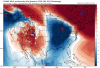
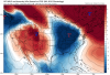
So here are the GFS, Euro, and FV3 runs from 5 days ago depicting tomorrow night.
View attachment 15503
View attachment 15505View attachment 15504
So the test was to see which run set the stage properly. Here's the GFS for that time frame and the other models aren't that far off, so it is a good example I'd say as they are maybe 1 or 2 MBs weaker or stronger.
View attachment 15508
Note the low is up in Michigan. Checking the Euro runs at 0Z of the same run on that Wednesday prior to the one further up showed very similar of a solution.
View attachment 15509
My idea that the Euro would come out on top seemed to hold here, and it overall seemed to know what it was doing regarding pressures.
So what implications does that have now? I say we should use this as a good example of how the GFS and FV3 have biases in overdoing high pressures and also how the FV3 was consistently wrong and ended up going the way of the other models. With that said, I'd pay attention to what the Euro is doing with the pressures regarding this upcoming system. Of course H5 is a different ball game and not surface related, and the system the GFS is spitting out seems driven by that. If such wild solutions keep showing up, or show up on the Euro, I'd say it would be worth watching how each model handles the situation.


")


