-
Hello, please take a minute to check out our awesome content, contributed by the wonderful members of our community. We hope you'll add your own thoughts and opinions by making a free account!
You are using an out of date browser. It may not display this or other websites correctly.
You should upgrade or use an alternative browser.
You should upgrade or use an alternative browser.
Pattern Fabulous February
- Thread starter PEA_RIDGE
- Start date
WXinCanton
Member
I feel for you if you take model output as a forecast.Looks like I can add 5.4 more inches to my fantasy repertoire. That puts me at 1/234 of my forecasted snowfall for the season. Really not bad considering. Been a great winter imo
Extremely overdone FV3 ice


Storm5
Member
The gefs is still all in through day 9


Sent from my iPhone using Tapatalk


Sent from my iPhone using Tapatalk
LOL. GEFS has pretty much been showing 3 inches all winter, and it has yet to verify. Maybe for once its rightThe gefs is still all in through day 9

Sent from my iPhone using Tapatalk
D
Deleted member 1449
Guest
I know most of you realize this but I feel compelled to say it: until otherwise noted, the GFS family should be considered complete garbage at this range.
As others have noted, the overall setup does not support a SE winter storm. Of course, there’s always the possibility that the GFS family is seeing something the others are missing, but I’d be beyond shocked if that were the case.
As others have noted, the overall setup does not support a SE winter storm. Of course, there’s always the possibility that the GFS family is seeing something the others are missing, but I’d be beyond shocked if that were the case.
B
Brick Tamland
Guest
Hogwash.... it doesn't work that way.
Actually, someone here did some research on it for RDU and most of the time that is how it is here.
I know most of you realize this but I feel compelled to say it: until otherwise noted, the GFS family should be considered complete garbage at this range.
As others have noted, the overall setup does not support a SE winter storm. Of course, there’s always the possibility that the GFS family is seeing something the others are missing, but I’d be beyond shocked if that were the case.
Agreed: Just posting to save others trouble of digging up.
packfan98
Moderator
To you point, for the first time in as far as I can remember, all overnight GFSs and FV3s (although the 6z FV3 is east based) , plus the 18z FV3 get to a -NAO before the end of their runs. I haven’t looked at the GEFS or the EPS.Cyclonic wave breaking towards the Azores Islands next week on both the EPS and GEFS is usually a precursor to an impending -NAO at least in the following week as a high builds over Scandinavia in response to the big wave break here near the Azores and retrogrades westward towards Greenland. This might be one of our only remaining hopes we have to get out of this crummy pattern before mid March.
View attachment 15546
D
Deleted member 1449
Guest
And I was not directing that toward you or anyone for that matter. I just had to get it off my chest. Now I feel better. ?Agreed: Just posting to save others trouble of digging up.
B
Brick Tamland
Guest
Until the Euro gets on board, I think we just have to have fun with how long the GFS and FV3 have a storm here this time before it goes poof. The ensembles have been terrible, too. The FV3 didbgrest here for the December storm, but the last three weeks it seems it has been spitting out storms in the 7 to 10 day range just hoping one of them sticks.
Jon
Member
To you point, for the first time in as far as I can remember, all overnight GFSs and FV3s (although the 6z FV3 is east based) , plus the 18z FV3 get to a -NAO before the end of their runs. I haven’t looked at the GEFS or the EPS.


Sent from my iPhone using Tapatalk
This has all the fixings for a just cold enough winter event In NC ... from storms that roll by before it they help bring down the cold air and the last storm gets to ride that cold air basically I think trends will soon be clear that NC will be cold enough for winter precip but more questionable outside of there. It honestly makes sense why this storm should happen.
NBAcentel
Member
Interested in that little disturbance that will head over VA/NC in a 100 hours, some of the gefs ensembles actually now show snow for a lot of nc
BHS1975
Member
Until the Euro gets on board, I think we just have to have fun with how long the GFS and FV3 have a storm here this time before it goes poof. The ensembles have been terrible, too. The FV3 didbgrest here for the December storm, but the last three weeks it seems it has been spitting out storms in the 7 to 10 day range just hoping one of them sticks.
Yeah it just got lucky .
Sent from my iPhone using Tapatalk
Storm5
Member
These horrible TT maps for the FV3 sure are fun to look at 

Sent from my iPhone using Tapatalk


Sent from my iPhone using Tapatalk
B
Brick Tamland
Guest
These horrible TT maps for the FV3 sure are fun to look at
Sent from my iPhone using Tapatalk
Even just half of that would be awesome.
So, how far out will the FV3 keep the storm this time before it goes poof? Or is it legit this time?
Storm5
Member
Even just half of that would be awesome.
So, how far out will the FV3 keep the storm this time before it goes poof? Or is it legit this time?
There will be a system next Tuesday -Thursday for sure. All guidance has one . Just gonna have to wait and see how it plays out . I’d expect rain and hope for some wintry . I still believe this favors the i40 Corridor from Arkansas to NC and points north
Sent from my iPhone using Tapatalk
ATLwxfan
Member
As we watch modeling tempting us from afar and promising a colder look (on the GFS and GEFS anyway) we see that the near term is trending warmer and warmer. I think we are continuing to see a cold bias that just continues to not pan out. Hard to know when that will change. Especially when the MJO doesn’t even behave as we suspect it should.
Sent from my iPhone using Tapatalk
Sent from my iPhone using Tapatalk
tonysc
Member
What does it matter whether it snows in December or February ? Is February snow better than December snow?
Well we can generally get bigger snows in February than we do in December. I've never seen more than a 3 to 4 inch snowstorm in December vs a few 8 to 12 inch ones in February.
tonysc
Member
Hogwash.... it doesn't work that way.
I agree with you, it doesn't work that way, but it sure works out that way most of the time in the Upstate of SC.
Thanks to the very persistent SER, Radiant is forecasting KATL’s Feb to be at 52.6, 9th warmest going back to when records started in 1879 and THE warmest of any of the 48 or so El Niño’s! This would bring the KATL DJF up to 49.0, which would be the 2nd warmest El Niño DJF with only 2015-6’s 49.5 being warmer. The 3rd warmest is 1991-2’s 48.6.
But there is a glimmer of good news on the 0Z GEFS day 14 that suggests a possible pattern change for the last few days of Feb into early March: the AO and NAO finally head back to negative and the PNA positive. Let’s see if this actually happens but at least it is there on the model late in the run.
But there is a glimmer of good news on the 0Z GEFS day 14 that suggests a possible pattern change for the last few days of Feb into early March: the AO and NAO finally head back to negative and the PNA positive. Let’s see if this actually happens but at least it is there on the model late in the run.
SOI another massive drop
Thats interesting because in my experience in Carrollton, GA our biggest snows have occurred in December and March.Well we can generally get bigger snows in February than we do in December. I've never seen more than a 3 to 4 inch snowstorm in December vs a few 8 to 12 inch ones in February.
Stormlover
Member
packfan98
Moderator
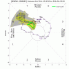
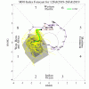
Interesting depictions of the MJO and the eventual ensemble evolution:
GEFS:

EPS:

CFS (week 3 map shown):
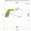

Both the GFS and CFS eventually get to blocking and a colder east. The CFS has the most favorable MJO prog, with the Euro second. The GFS is ugly, but H5 turns out better. Who knows how it will play out. Normally, conventional wisdom should highly favor the EPS. But I remember the EPS showing good pattern after good pattern, when the GEFS was showing -PNA/warm east. We know what happened. Anyway, it will be interesting to watch. Hopefully, the 12z runs continue to advertise the development of a legit -NAO. Given what Webber posted earlier, there is reason for optimism.
GEFS:


EPS:


CFS (week 3 map shown):


Both the GFS and CFS eventually get to blocking and a colder east. The CFS has the most favorable MJO prog, with the Euro second. The GFS is ugly, but H5 turns out better. Who knows how it will play out. Normally, conventional wisdom should highly favor the EPS. But I remember the EPS showing good pattern after good pattern, when the GEFS was showing -PNA/warm east. We know what happened. Anyway, it will be interesting to watch. Hopefully, the 12z runs continue to advertise the development of a legit -NAO. Given what Webber posted earlier, there is reason for optimism.
NBAcentel
Member
Six Mile Wx
Member
Storm5
Member

Sent from my iPhone using Tapatalk
NBAcentel
Member
Hmm, building heights in the SE ?
NBAcentel
Member
it was a good run


NBAcentel
Member
Gonna cut for sure, ridging more west this run, still some front end wintry precip for CAD areas


