This MSLP look is mildly intriguing


Going to be saving the 12z and 18z model runs. Lol. Of Course it is for the archives ..
Hand the keys over. ????I’ll take this and give the site to brick
Sent from my iPhone using Tapatalk


38.6 inches max, lol
View attachment 15491

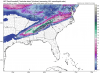
No doubt this was a step in the right direction @Jimmy Hypocracy, maybe a tad, tiny bit weaker SER then boomView attachment 15495
Same run DK
Just give me the 8 inches of snow and I'll cash out. Or just one run that decimates ATL and N GA. I just want to be in the 2 feet area once LOL. Looks to me that this solution is only produced because of the SER aiding in moisture flow with a perfectly timed cold press. I put my money on the SER growing and shoving this system into nonexistence, but it's fun to ponder.38.6 inches max, lol
View attachment 15491
")
Nope. Bad setup for us. Might look good on surface maps but we’re a long long long way off. Very low probability atm. I’d say anywhere from NW GA to Chicago is still in the game at this pointMaybe step in right direction. But certainly not a South Carolina upstate snow storm
Sent from my iPhone using Tapatalk
Maybe step in right direction. But certainly not a South Carolina upstate snow storm
Sent from my iPhone using Tapatalk

The appetizerNope. Bad setup for us. Might look good on surface maps but we’re a long long long way off. Very low probability atm. I’d say anywhere from NW GA to Chicago is still in the game at this point
Oh yeah I didn’t really see what the upstate had, this run gave me a foot plus of paste in rowan county in nc, lol, I needa stay with what I said and not be exciting about this, just something to watch
I think you would be in trouble, if there doesn’t start to be a wedge with this!? Those mountains are tall
What’s is discouraging is most of NC can still score with late cold air. Especially areas north of 85 in NC. We can’t do it. Maybe a backend dusting if the stars align in a setup like thisI think you would be in trouble, if there doesn’t start to be a wedge with this!? Those mountains are tall
What’s is discouraging is most of NC can still score with late cold air. Especially areas north of 85 in NC. We can’t do it. Maybe a backend dusting if the stars align in a setup like this

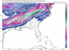
As a few others have alluded to above, the GFS wasn't that far off from producing some snow in the piedmont of north-central NC around Day 5 this Saturday night w/ a trailing, very strong s/w that comes in late on Sat into Sat night. If the wave can come in about 8-12 hours slower, this could end up producing a nice little bit of snow for a few folks. Still a little ways to go here but worth watching...
View attachment 15500
.png")