packfan98
Moderator
Here's JB's video for today:
There was also a Major Storm for parts of Northwest MS and Memphis before Christmas that year. I believe I found a report a couple days ago that stated there was still 10 inches of snow on the ground for Memphis, Christmas Day.
And southeast of us too.More recently I remember 2009/10 was painful for RDU, still a good winter on the average, but witnessed storm after storm from December on nailing Roxboro and places North repeatedly.

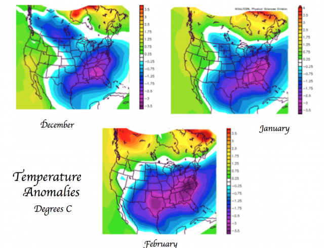
Holy crap that’s cold!Here is the new Pioneer Model forecast which greatly resembles the EPS
And southeast of us too.
Here is the new Pioneer Model forecast which greatly resembles the EPS


Looks more like a general idea of temperature differences that should be reduced in severity. It's only existed a few years right? Any other years we can compare?I believe the pioneer “model” aka a whole bunch of years thrown into a climate composite and called a model, hasn’t done well since they started it. It’s always too cold (imagine that)
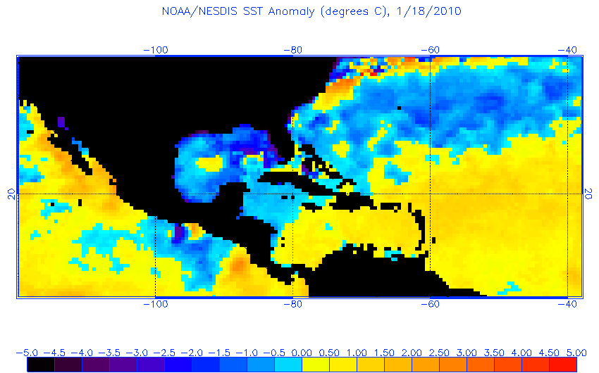
Last year’s:

Reality:

Sent from my iPhone using Tapatalk
I believe the pioneer “model” aka a whole bunch of years thrown into a climate composite and called a model, hasn’t done well since they started it. It’s always too cold (imagine that)
Last year’s:
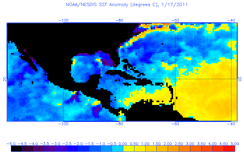
Reality:
Sent from my iPhone using Tapatalk
Looks more like a general idea of temperature differences that should be reduced in severity. It's only existed a few years right? Any other years we can compare?


JB said the Pioneer model does better with cold winters. Idk. We shall seeAnother example Winter 2016-17
Pioneer Model

Reality

This isn’t pioneer but it’s still Bastardi


Lesson: JB has a cold bias. Lol
That’s like saying a thief like open doors.I love how due we are here in the upstate. I feel something brewing this year
JB said the Pioneer model does better with cold winters. Idk. We shall see
I love how due we are here in the upstate. I feel something brewing this year
JB said the Pioneer model does better with cold winters. Idk. We shall see
 models for everyone !!!!!
I don’t know what the hell happened in December of 1963 . But from what Webber and others have posted , if J.B. nails this I will 100 percent slosh in the Tub with him because the general theme from most is December will be above normal temp wise

Why shower, when you can slosh in the tub?Had to shower after watching it.

I really want to see where we are in reality around Thanksgiving and what the models are spitting out for early December. The ridging across the north Pacific into Alaska and the arctic circle along with the Scandinavian ridge has me intrigued.
Sent from my SM-G955U using Tapatalk
Any of those other seasonal models come out yet, like the the Jamstec, UK, or JMA? All I’ve seen is the Yuro.
JMA seasonal is out in a day or two, the 4 week forecast is zonal and not cold up until Dec 6 which most long range forecasts are predicting.
I posted the Beijing Climate Center seasonal here:
January is cold, other than that it’s normal but pretty decent patterns at 500mb thru March. It’s not a model talked about much but they’ve improved their graphics year to year, and upgraded the model this year. It’s ran once monthly like the JMA 3mo model.
Sent from my iPhone using Tapatalk
JMA seasonal update:
Sent from my iPhone using Tapatalk


The CFSv2 is an idiot. They need to roll the v3 out. Not just saying that because it's warm. It's just always warm. It's hard coded to be warm. Every now and again, it breaks character and gives you a wtf cold map, but that is surely accidental.Here is the Nov CFSv2 seasonal for DJF. Maybe it will score coup as every other seasonal is stormy/blocky for the east/southeast.
View attachment 7311
View attachment 7312
The tail end of November into early December certainly is starting to get my attention as a period that could yield a nice storm near the eastern US as a massive Scandinavian blocking high retrogrades westward towards Greenland, the classic way we get really nice -NAOs. Unlike this past week, we're starting off with a much bigger Scandinavian blocking ridge which means more planetary vorticity advection, and a bigger ridge makes it to Greenland (all else equal) vs this past week, we will have a deeper Aleutian Low as the Pacific jet briefly extends in response to a + east Asia mountain torque earlier this week and tropical forcing shifting into the West-Central Pacific. There's usually an inverse relationship between the Aleutian & Icelandic lows because strong Aleutian lows discourage downward WAFz propagation into northern North America and Greenland, effectively discouraging deep Hudson Bay vortices (+TNH) which often couple to +NAOs, a pattern we've become very familiar with the last several years. We'll see what happens but this period beginning after November 25th and going into the first several days of December might hold some promise if we can get another bounce or two to come in our favor. I personally think the NE US stands a better shot to really score a nice winter storm at least earlier in this timeframe, but we'll see!
View attachment 7310

Hey man, I got the Scandinavian ridging, the NAO, the Low of Aleutia and tropical forcing. I even know a little about TNHs, mountain torquing, and exponential planetary vorticity advective coriolis deviation convergence. But for the life of me, I can't figure out what a WAFz is? What that?The tail end of November into early December certainly is starting to get my attention as a period that could yield a nice storm near the eastern US as a massive Scandinavian blocking high retrogrades westward towards Greenland, the classic way we get really nice -NAOs. Unlike this past week, we're starting off with a much bigger Scandinavian blocking ridge which means more planetary vorticity advection, and a bigger ridge makes it to Greenland (all else equal) vs this past week, we will have a deeper Aleutian Low as the Pacific jet briefly extends in response to a + east Asia mountain torque earlier this week and tropical forcing shifting into the West-Central Pacific. There's usually an inverse relationship between the Aleutian & Icelandic lows because strong Aleutian lows discourage downward WAFz propagation into northern North America and Greenland, effectively discouraging deep Hudson Bay vortices (+TNH) which often couple to +NAOs, a pattern we've become very familiar with the last several years. We'll see what happens but this period beginning after November 25th and going into the first several days of December might hold some promise if we can get another bounce or two to come in our favor. I personally think the NE US stands a better shot to really score a nice winter storm at least earlier in this timeframe, but we'll see!
View attachment 7310
The CFSv2 is an idiot. They need to roll the v3 out. Not just saying that because it's warm. It's just always warm. It's hard coded to be warm. Every now and again, it breaks character and gives you a wtf cold map, but that is surely accidental.


Bless it's heart. It tried.For our last weak nino this is what the Nov run had v/s what verified. Not bad
View attachment 7313 View attachment 7314
Bless it's heart. It tried.