• Hello, please take a minute to check out our awesome content, contributed by the wonderful members of our community. We hope you'll add your own thoughts and opinions by making a free account!

Wintry Winter 2018-19 Discussion

If there is October snow I hope it only happens in the mountains. Nothing good has come out of getting snow in October anywhere else lol.
 
Just for fun... the 00z FV3 showed this out at around 300 hours.
fv3p_mslp_pcpn_frzn_us_51.png
You might be able to update the code, but you can’t take the GFS out of the GFS!
 
It looks like all the key ingredients are coming together for a lot of winter storm chances this winter. Of course, we have seen that before. You can have the best players on the field, but it doesn't guarantee a win.
 
If there is October snow I hope it only happens in the mountains. Nothing good has come out of getting snow in October anywhere else lol.

One of the last and only "area-wide" snow events in late October east of the mountains in NC occurred in 1910 & 1903. It can certainly still happen today as evidenced by what those in the midlands of SC saw on Nov 1, 2014 but it's exceptionally hard to do so.

October 28-29 1910 NC Snowmap.png
October 24-25 1903 NC Snowmap.png
 
One of the last and only "area-wide" snow events in late October east of the mountains in NC occurred in 1910 & 1903. It can certainly still happen today as evidenced by what those in the midlands of SC saw on Nov 1, 2014 but it's exceptionally hard to do so.

View attachment 7016
View attachment 7017
I wonder how the winters were after that? The last time it happened outside of the mountains there was no snow in winter from what I remember.
 
I just finished updating my Ensemble Oceanic Nino Index (ENS ONI) to the most recent tri-monthly period. I have the raw monthly, tri-monthly data, ranks, standardized data available in excel format so everyone can download & scrutinize the data on their own accord.

https://www.webberweather.com/ensemble-oceanic-nino-index.html


We're following the 1880-81 weak El Nino event virtually to a T this year.

Screen Shot 2018-10-16 at 4.50.53 PM.png

Screen Shot 2018-10-16 at 4.50.09 PM.png

The 1880-81 winter (vs the 1871-1900 period) was fantastic in general over the eastern US.
p0Mf_hA_5k.png
 
I just finished updating my Ensemble Oceanic Nino Index (ENS ONI) to the most recent tri-monthly period. I have the raw monthly, tri-monthly data, ranks, standardized data available in excel format so everyone can download & scrutinize the data on their own accord.

https://www.webberweather.com/ensemble-oceanic-nino-index.html


We're following the 1880-81 weak El Nino event virtually to a T this year.

View attachment 7021

View attachment 7022

The 1880-81 winter (vs the 1871-1900 period) was fantastic in general over the eastern US.
View attachment 7020
What was snowfall like that year? Now that I looked it up it was said to be the worst or best winter in US history depending on if u like or don’t like winter.
 
Last edited:
What was snowfall like that year? Now that I looked it up it was said to be the worst or best winter in US history depending on if u like or don’t like winter.

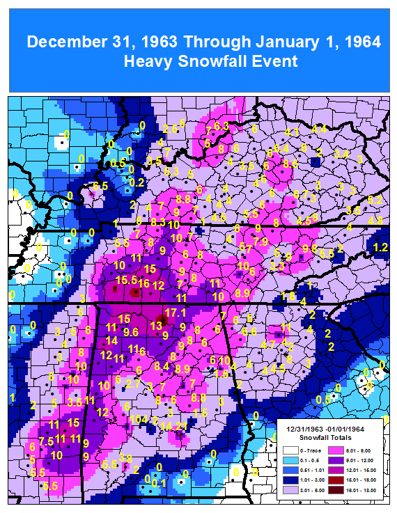
It was a great winter at Atlanta because the main event was a 6" snow from only 0.28" melted on 12/29. So, 850s might very well have been near or colder than -5C. The next day had a frigid low of 1! Then there was a smaller wintry event on 1/1.
Dec/Jan were 3 colder than normal while Feb was near normal. Mar was 5 colder than normal. The warmest day in DJF was only 70.
In a certain respect, it was a miserable winter with several very cold rains. But that's pretty normal in a cold winter. Total precip. was way above normal or somewhat reminiscent of 1935-6.
 
Last edited:
What was snowfall like that year? Now that I looked it up it was said to be the worst or best winter in US history depending on if u like or don’t like winter.

The different large-scale climate & small sample size obviously changes how one interprets the amount of snowfall that winter but it was above or well above average from the stations that I've come across in the Carolinas.
 
Something to put in your back pocket going forward wrt mountain torque events and how the jet stream/waveguide subsequently responds to them. Positive mountain torques (+MTs) act in the same sense as the mechanical disturbance induced by the large-scale mountain ranges w/ a lee side trough of low pressure on their eastern or leeward flank and a ridge upstream on their western or windward side inducing a eastward directed pressure gradient force that leads to a force directed towards the earth opposite to its sense of rotation (which is towards the west). Since the total angular momentum budget of both the earth and atmosphere are conserved and approximately zero, the cross-barrier, westward pressure gradient force (from high to low pressures) created in part by synoptic-scale Rossby Waves traversing major mountain ranges, like the Himalayas denoted here, the slowing of earth’s rotation from a +MT event allows the atmosphere to speed up. This then leads to a positive atmospheric angular momentum anomaly that’s indicative of stronger, more extensive jet streams and in this case, a big trough in the Gulf of Alaska which will help instigate the eventual monster wave break/extratropical cyclone near the E US at the end of October.


It honestly took forever for me to finally wrap my brain around what a Mountain Torque was and what it actually meant for the planetary-scale pattern, I'm hoping it finally makes sense to some after reading this and my tweet.
 
Last edited:
Seems like we are close to setting analogs aside and it’s time to start looking at real atmospheric developments.

Our CP Niño is beginning to establish itself.
NOTE: check out the + anomalies south of Alaska. +PNA??
0797662E-D260-4BC2-8E25-E8FB9EC97B7E.png

CP Niño is traditionally the optimal ENSO pattern for the east.

This is for January-March.

CP niño is the best for cold in the east and a suppressed storM track. See fig (e-f)
3E53DACD-5C13-4521-B127-5B4617FDD0B9.jpeg

Low solar will increase our blocking chances. I was doing some digging and found that there is a case that claims that low solar years are 4x more likely to have decent north hemisphere blocking compared to non-low solar.


Our NAO is forecast to go negative for the first time in months.
55128537-885E-46B1-AB4E-C0A08EBCDBDE.png


Honestly this is about as good a look as you can get going into late October. Analogs and models are great, but the fact that our atmospheric patterns are currently evolving to support those cold and snowy models and analogs has MUCH more weight than analogs.


Buckle up. I see a fun winter.
 
Seems like we are close to setting analogs aside and it’s time to start looking at real atmospheric developments.

Our CP Niño is beginning to establish itself.
NOTE: check out the + anomalies south of Alaska. +PNA??
View attachment 7023

CP Niño is traditionally the optimal ENSO pattern for the east.

This is for January-March.

CP niño is the best for cold in the east and a suppressed storM track. See fig (e-f)
View attachment 7024

Low solar will increase our blocking chances. I was doing some digging and found that there is a case that claims that low solar years are 4x more likely to have decent north hemisphere blocking compared to non-low solar.


Our NAO is forecast to go negative for the first time in months.
View attachment 7025


Honestly this is about as good a look as you can get going into late October. Analogs and models are great, but the fact that our atmospheric patterns are currently evolving to support those cold and snowy models and analogs has MUCH more weight than analogs.


Buckle up. I see a fun winter.
Great post buddy
 
Seems like we are close to setting analogs aside and it’s time to start looking at real atmospheric developments.

Our CP Niño is beginning to establish itself.
NOTE: check out the + anomalies south of Alaska. +PNA??
View attachment 7023

CP Niño is traditionally the optimal ENSO pattern for the east.

This is for January-March.

CP niño is the best for cold in the east and a suppressed storM track. See fig (e-f)
View attachment 7024

Low solar will increase our blocking chances. I was doing some digging and found that there is a case that claims that low solar years are 4x more likely to have decent north hemisphere blocking compared to non-low solar.


Our NAO is forecast to go negative for the first time in months.
View attachment 7025


Honestly this is about as good a look as you can get going into late October. Analogs and models are great, but the fact that our atmospheric patterns are currently evolving to support those cold and snowy models and analogs has MUCH more weight than analogs.


Buckle up. I see a fun winter.
That’s beautiful! I feel like we’re due for a good winter.
 
Seems like we are close to setting analogs aside and it’s time to start looking at real atmospheric developments.

Our CP Niño is beginning to establish itself.
NOTE: check out the + anomalies south of Alaska. +PNA??
View attachment 7023

CP Niño is traditionally the optimal ENSO pattern for the east.

This is for January-March.

CP niño is the best for cold in the east and a suppressed storM track. See fig (e-f)
View attachment 7024

Low solar will increase our blocking chances. I was doing some digging and found that there is a case that claims that low solar years are 4x more likely to have decent north hemisphere blocking compared to non-low solar.


Our NAO is forecast to go negative for the first time in months.
View attachment 7025


Honestly this is about as good a look as you can get going into late October. Analogs and models are great, but the fact that our atmospheric patterns are currently evolving to support those cold and snowy models and analogs has MUCH more weight than analogs.


Buckle up. I see a fun winter.
Thanks!
Great info.
Analogues are still fun to look at though ... for example and just for kicks ...

sfc_count_sup814_temp.gif

:cool:
 
Back
Top