Shaggy
Member
Seems to have drawn in a touch of drier air. Capped potential for sure because of the previous convective burst had maintained it could have ramped up a bit more.
It did pretty well with my area and the further west position versus the globals that had this moving due North through the sounds. I said a few times it was the hi res versus the globals and I'd say the hi res is winning here.NAM still showing 50+ wind gust here in the morning, just once I'd like to see the NAM wind gust forecast be right, just once.

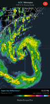
Looks impressive for a tropical stormIf this is the true center it appears to have resumed some westward component to it
70-90 will be scary
That's what WRAL is saying.70-90?
You getting these bigger gusts all of a sudden?70-90 will be scary
Yea, shaking continues. I heard something snapYou getting these bigger gusts all of a sudden?
Definitely my strongest gust of the night a few minutes agoYea, shaking continues. I heard something snap
Im wondering if they are expecting severe weather when it landfalls on the east side.That's what WRAL is saying.
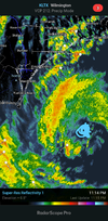
If this is the center that new big band on the west side gets onshore someone is gonna get a ton rain and some decent winds
Yeah and it's still moving to the left it would seemBuoy under that band had two 60 Knot Gusts. https://www.ndbc.noaa.gov/station_page.php?station=41037
| Humidity | 100% |
| Wind Speed | N 30 G 52 mph |
| Barometer | 29.59 in (1001.9 mb) |
| Dewpoint | 61°F (16°C) |
| Visibility | 10.00 mi |
| Last update | 22 Sep 10:53 pm EDT |
One of those convective cells could gust to 60 mphThe center is possibly benefiting from some land interaction.....if this thing can build and maintain a solid center then maybe we see higher gust further inland....still I think gust over 50 anywhere away from the coast will be rare....unless a lot changes.
Yeah and it's still moving to the left it would seem
The center seems to be getting better defined. They had some poor recon planning

I THINK you get 50+ eastA little bit of expanding colder cloud tops SW of the center, looks like some of the dryer air has been pushed away from the center as well so it seems to be getting ready to try another burst of convection which would be well timed with the recon headed that way....
Soe big gusts stil here without the rain to mix it downI THINK you get 50+ east
I THINK you get 50+ east
Soe big gusts stil here without the rain to mix it down