Shaggy
Member
I'm west of the center so not much gradient for me. I'm only about 90 miles from the centerThere are some pretty good winds all the way to Virginia Beach. Pressure Gradient is tight.
I'm west of the center so not much gradient for me. I'm only about 90 miles from the centerThere are some pretty good winds all the way to Virginia Beach. Pressure Gradient is tight.

I fell asleep. very gusty984mb first pass....new convection flare up underway right in time for recon.
WOWMHX just changed the language of the TS warning here....I dunno where they getting this from lol....this is a big jump from earlier which topped us out at 40 mph...
Pitt-
1055 PM EDT Fri Sep 22 2023
...TROPICAL STORM WARNING REMAINS IN EFFECT...
* LOCATIONS AFFECTED
- Greenville
- Farmville
- Grifton
* WIND
- LATEST LOCAL FORECAST: Equivalent Strong Tropical Storm force
wind
- Peak Wind Forecast: 45-60 mph with gusts to 75 mph
- Window for Tropical Storm force winds: until early Saturday
afternoon
The point in click seems more reasonable on the high end....
Saturday
Showers and possibly a thunderstorm. High near 70. Very windy, with a northeast wind 30 to 40 mph becoming east 11 to 21 mph in the morning. Winds could gust as high as 55 mph. Chance of precipitation is 90%. New rainfall amounts between three quarters and one inch possible.
This may come right over you.Yeah I'm not seeing it....if we gust over 50 I will be shocked

So close to a cane2:00 AM EDT Sat Sep 23
Location: 33.8°N 77.1°W
Moving: NNW at 12 mph
Min pressure: 984 mb
Max sustained: 70 mph
Stronger winds in the east.
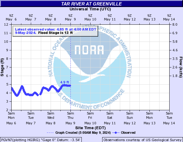
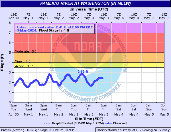
NE Winds pushing water backwards in Chesapeake Bay right now.
This may come right over you.
that deep convection is coming right at landfall. You will get rockedYeah who knows what we will see, I figure sometime between dawn and mid morning will be peak for this area...

I can tell here its still staying very gusty with that burst
If it could have ever wrap the center with storms it mught have done something.Minimum Extrap. Pressure: 982.2mb at 06:19z https://cyclonicwx.com/recon/mission/OPHELIA_AF302_0216A/
whats the mb?Recon is finding weird flight level winds, seems very low which is odd as some of the buoys have higher surface winds than what the flight level show fir those areas.....
that is way below min cane threshold of 993982 last pass
that is way below min cane threshold of 993
No but the very low pressure means when you get in a convective band or cell you will get blastedThis thing is no where close to a cane though
No but the very low pressure means when you get in a convective band or cell you will get blasted

yikes
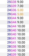
that should be a cane072930 3403N 07656W 6963 02970 9807 +129 +008 187035 037 /// /// 03
Minimum Extrapolated Pressure 980.7
Minimum Estimated Dropsonde Pressure: 980.5mb at 06:19z
The purple 74-96 mph flight level.
max surface wind is often estimated to be 90% of observed maximum flight-level wind. vary from storm to storm, and can range from ~70% to >100%.