• Hello, please take a minute to check out our awesome content, contributed by the wonderful members of our community. We hope you'll add your own thoughts and opinions by making a free account!

Tropical TS OPHELIA ?

Tropical Storm Ophelia Tropical Cyclone Update
NWS National Hurricane Center Miami FL AL162023
620 AM EDT Sat Sep 23 2023

...OPHELIA MAKES LANDFALL IN NORTH CAROLINA...

Doppler Radar images, Air Force Hurricane Hunter data and surface
observations indicate that Ophelia made landfall near Emerald Isle
in North Carolina around 615 am EDT (1015 UTC) with estimated
maximum winds of 70 mph (110 km/h).

An observation in Cape Lookout, North Carolina, recently reported
sustained winds of 61 mph (98 km/h) with a gust to 73 mph (117
km/h).

SUMMARY OF 620 AM AST...1020 UTC...INFORMATION
----------------------------------------------
LOCATION...34.7N 77.0W
ABOUT 25 MI...45 KM WNW OF CAPE LOOKOUT NORTH CAROLINA
ABOUT 75 MI...120 KM NE OF CAPE FEAR NORTH CAROLINA
MAXIMUM SUSTAINED WINDS...70 MPH...110 KM/H
PRESENT MOVEMENT...NNW OR 345 DEGREES AT 9 MPH...15 KM/H
MINIMUM CENTRAL PRESSURE...981 MB...28.97 INCHES

$$
Forecaster Kelly/Cangialosi/Papin/Delgado
 
In New Bern to watch in-laws cat and button the place down. Nothing major here yet, some flooding down around Lawson’s Creek and Union Point. Winds have been mild at best but looks like we may have some coming as I think we may catch part of the “eye wall”. Going to ride around in a bit.


Sent from my iPad using Tapatalk
 
Getting some stronger gusts now, guessing since the pressure change is happening quickly. The band that just went through did not have much in it. I’m in a bit of a sheltered area but can see trees in the distance that are not and I’d rough estimate 50mph tops. Prob getting a bit closer to 60 close to the river just due to open area.

e4bbfc0ef6eb5f092a39e7d468b04a2f.jpg


Sent from my iPhone using Tapatalk
 
Well I had no sooner than finished my last post when we had a good wave of winds hit. I’m eyeballing it here so sorry, but would say they were close to 65.
Knocked out power in this sub-division in James City.

In-laws were supposed to fly into New Bern today at 2pm, I am pretty sure that’s not happening.


Sent from my iPhone using Tapatalk

Yeah there is a core about 30 miles across maybe with the 60+ stuff....looks like its going to track up Hwy 17 though probably slowly weaken as it does.
 
IMG_0352.jpeg
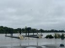
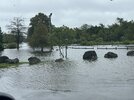
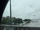
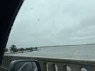
Out riding around and taking my wife to get Starbucks (of course). Not seeing anything substantial around James City, some decently large branches broken off but no trees down yet. Power is out in most if not all of James City all the way out to Harris Teeter in Colors. Going to head downtown toward union to check out flooding. Tons of people out and about. Trying to post a few photos but app being a pain.


Sent from my iPhone using Tapatalk
 
Last edited:
Starting to feel tropical stormy out, pressure down to 992, rain taking on more of a sheet appearance coming down the street. Now under a FFW until noon, ditches are full and lots of ponding in the yard.

IMG_6270.jpeg
 
Great storm. It's a tropical storm but has a nor'easter feel to it (..at my location). currently it's 57 and breezy (to say the least). Haven't received as much rain as I thought. Currently a little over an inch, but there's still a few more bands to pass through. Looks like a potato soap day coming up.
 
Looks like the storm is moving/jogging N/NW. That "break" area should move right over you. Definitely step outside to see if the winds die down some.
Yep, nice little jog NW. That band has 1-3 inch rainfall rates and the HRRR/NAM still insist on some 50 mph wind gust even up here (lol). That won't happen here but could really pile up the rainfall totals in a couple of hours

Peak wind gust still 37 but it is getting very gusty out now, actually some of the best gust yet
 
Very minimal impacts in New Bern, nothing I haven’t seen with a stiff north or north east breeze over a day.
 

Attachments

  • IMG_0368.jpeg
    IMG_0368.jpeg
    1.7 MB · Views: 16
  • IMG_0364.jpeg
    IMG_0364.jpeg
    2.5 MB · Views: 16
  • IMG_0358.jpeg
    IMG_0358.jpeg
    2.1 MB · Views: 16
  • IMG_0355.jpeg
    IMG_0355.jpeg
    1.7 MB · Views: 14
Last edited:
Pretty good surge on the Pamlico at Washington going on right now. At 5’ Main Street is flooded and water is in homes at Wichards Beach.

IMG_6272.jpeg
 
Flash flood warning just got extended from noon to 3pm. Just crossed the 5” mark for the event including 3.75” so far today, in a really god spot to be close to jackpot for amounts, I’ll post some pics once things settle down, the flooding outback is pretty impressive.

IMG_6278.jpeg
 
Pine Log branch which feeds in to Little Contentnea Creek a couple miles downstream from my house. Probably have to go back to Florence the last time I saw it this high. Cyprus I planted in the low ground I’m sure are loving it.

IMG_6292.jpeg

IMG_6295.jpeg

IMG_6296.jpeg

^ for some reason my neighbor thought it would be wise to plant brambles and blueberry’s down here
 
Back
Top