-
Hello, please take a minute to check out our awesome content, contributed by the wonderful members of our community. We hope you'll add your own thoughts and opinions by making a free account!
You are using an out of date browser. It may not display this or other websites correctly.
You should upgrade or use an alternative browser.
You should upgrade or use an alternative browser.
Tropical TS OPHELIA ?
- Thread starter Downeastnc
- Start date
Shaggy
Member
Need recon in there soonAlmost as if it has stalled to get it's act together
lexxnchloe
Member
As close to a hurricane as you can get.
Is there another recon scheduled or are we relying on radar at this point?Need recon in there soon
Shaggy
Member
Didn't see one on the scheduleIs there another recon scheduled or are we relying on radar at this point?
Approaching 10K with about 12% of Lenoir county now in the dark. Seems like every time someone spits on the ground Duke Energy goes down.3k without power in NC already. Doubt there will be much structural damage but long duration, decent rainfall and decent gust probably gonna be a good number of power outages. More than a nuisance event yet not that big of a deal either kinda situation
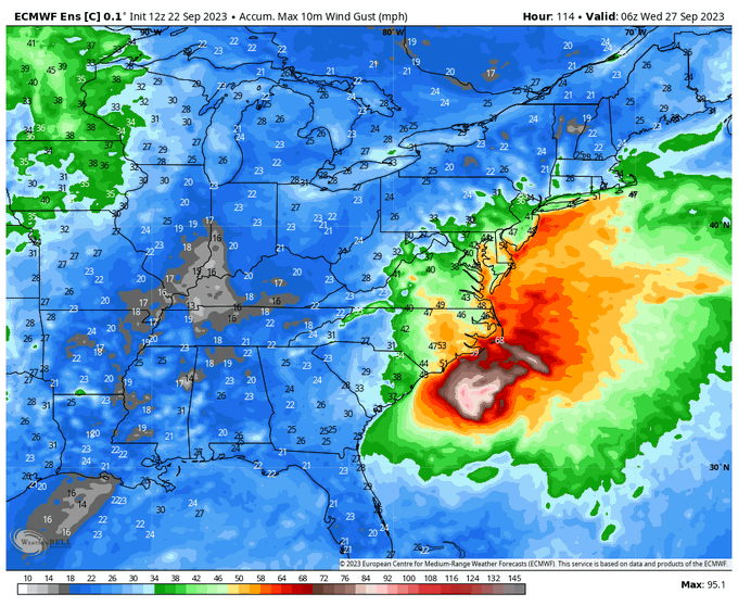
22Z HRRR Wind Gusts
View attachment 092223.mp4
View attachment 092223.mp4
lexxnchloe
Member
This went from a non tropical mess to this in a hurryWow, 60 mph gust reported at New River
That's how we do it the past few years.This went from a non tropical mess to this in a hurry
Interesting, I believe there have already been gust stronger than any the HRRR shows. Maybe I'm being a weather nerd but I think the HRRR might be a little underdone on those gust22Z HRRR Wind Gusts
View attachment 137153
Downeastnc
Member
Wow, 60 mph gust reported at New River
Center is still pretty far south as well....guess MHX gonna need to revise that graphic you posted earlier lol.
Downeastnc
Member
Interesting, I believe there have already been gust stronger than any the HRRR shows. Maybe I'm being a weather nerd but I think the HRRR might be a little underdone on those gust
Yeah its hard to say what to expect later when the center is sitting over the south central coastal plains...I think Topsail to Kinston to Wilson to your back yard might be the center track if it stays as far west as it appears to be....hard to imagine only gusting into the 30's, especially since we are pushing 40 already now with the center 200 miles south of us.
Well considering we just had a gust to 30 here, doubt we stay below 40 when this thing comes inland but we shall seeYeah its hard to say what to expect later when the center is sitting over the south central coastal plains...I think Topsail to Kinston to Wilson to your back yard might be the center track if it stays as far west as it appears to be....hard to imagine only gusting into the 30's, especially since we are pushing 40 already now with the center 200 miles south of us.
Last edited:
lexxnchloe
Member
This gust map i posted from the 12z euro seems pretty accurate
Yeah, I think we’re going to be saying how good it was that it didn’t get 12 more hours over waterThis went from a non tropical mess to this in a hurry
This went from a non tropical mess to this in a hurry
Ehhh, I still think it looks like a non-tropical mess.
Edit: Mess is too harsh a word. It looks cool for what it is. It looks like mess on the hurricane scale.
Last edited:
Downeastnc
Member
Surge is already getting into New Bern....might get another couple of feet in there before all said and done...
NBAcentel
Member
Storm looks like a mid latitude cyclone to me lol
lexxnchloe
Member
Surge is already getting into New Bern....might get another couple of feet in there before all said and done...
Big surge for a 70 mph storm
Shaggy
Member
Dennis in 99' put 9 feet of water into little Washington. This will put 5 or so is my guess. Belhaven will flood badly as wellBig surge for a 70 mph storm
Downeastnc
Member
Gonna need to see some fresh convection soon or it might have peaked...at least temporarily.
Strongest gust yet just now definitely heard some snapped limbs
Downeastnc
Member
Stronger showers and storms out over the sounds pushing inland...not seeing a ton of rotation but if anything going to toss out a rogue tornado or two its that stuff....
lexxnchloe
Member
JB calls it
Looking pretty solid on radar
Downeastnc
Member
Looking pretty solid on radar
really need to see one last big flare up right on the center....not sure it has time to do that, it will be onshore in 6-8 hrs probably.
lexxnchloe
Member
lexxnchloe
Member
Often they will tighten at landfallreally need to see one last big flare up right on the center....not sure it has time to do that, it will be onshore in 6-8 hrs probably.
Downeastnc
Member
As these heavier showers roll in the winds here have picked up again....probably getting our first gust into the 40's...usually when I can sit here at my PC and hear the wind in the stand of huge pine trees across the road I know things are getting 40+.
The real part that sucks though is I got to work 3rd shift tonight and work has not called it off so I got to work 11pm to 7am....
The real part that sucks though is I got to work 3rd shift tonight and work has not called it off so I got to work 11pm to 7am....
Shaggy
Member
Our time with ophelia is almost up. Center will be east of us by 90 miles in a couple of hours after that we should see winds drop quicklyTell them i said you can call out

Where are you at now? Your tag still says GreenvilleOur time with ophelia is almost up. Center will be east of us by 90 miles in a couple of hours after that we should see winds drop quickly
lexxnchloe
Member
Yes I still wonder how far away it will landfallOur time with ophelia is almost up. Center will be east of us by 90 miles in a couple of hours after that we should see winds drop quickly
lexxnchloe
Member
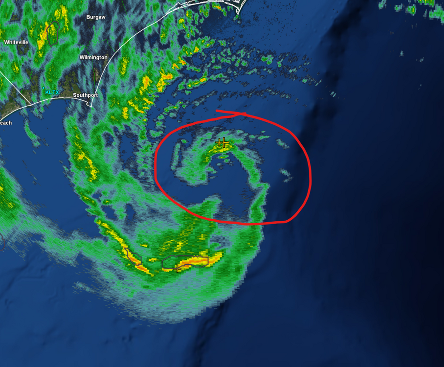
They should still be doing reconNascent core, will it find time & water?View attachment 137154
Shaggy
Member
LelandWhere are you at now? Your tag still says Greenville
Belle Lechat
Member
- Joined
- Aug 29, 2021
- Messages
- 1,547
- Reaction score
- 1,224
They should still be doing recon
The mission that finished.
Recon Data | CyclonicWx
Real-time recon data from aircraft flying into tropical cyclones.
cyclonicwx.com
Next one scheduled for today departs at 10:45 PM ET.
FLIGHT TWO - TEAL 72
A. 23/0530Z,1130Z
B. AFXXX 0216A CYCLONE
C. 23/0245Z Departure Time
D. 34.2N 76.1W
E. 23/0500Z TO 23/1130Z Time on Station
F. SFC TO 10,000 FT
G. FIX
Last edited:
Shaggy
Member
Had a decent gust just now with that bandYes I still wonder how far away it will landfall
NAM still showing 50+ wind gust here in the morning, just once I'd like to see the NAM wind gust forecast be right, just once.