lexxnchloe
Member
983 is well below cane threshold of 993 so i think 50+ gusts are a lock for your locationNewer hot towers going up might get one more burst of intensification. I could see 975-980 by landfall.
983 is well below cane threshold of 993 so i think 50+ gusts are a lock for your locationNewer hot towers going up might get one more burst of intensification. I could see 975-980 by landfall.
Just had my best gusts with this little band moving through983 is well below cane threshold of 993 so i think 50+ gusts are a lock for your location
some shaking!!Just had my best gusts with this little band moving through
yeah had one smack the house that I knew was over TS force. I'm only a mile off the Brunswick river.some shaking!!

They must be expecting it to go due northNWS Newport definitely increased their forecast from this morning
View attachment 137142

 weather.cod.edu
They shouldHope they keep recon in there until landfall

 weather.cod.edu
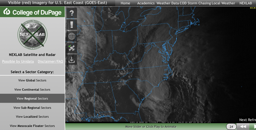
Center got pulled under the deepest convection, once "stacked" it will resume N/NW movementToo my "untrained eyes" Via radar, looks to be tracking due, WEST?..
COD-NEXLAB : Dual-Pol Radar for LTX
Dual-Pol NEXRAD Data for provided by College of DuPage Meteorology (NEXLAB)
NWS Newport definitely increased their forecast from this morning
View attachment 137142

Some places will get significant floodinglooks to be a interesting evening (here) in SENC.. FOLKS are UNAWARE.. of what's unfolding..
Very surprisingShout out to @Brick Tamland not under any sort of TS watxh or warning in brunswick. Sc has high wind advisories to my south we have NOTHNG and im gusting upper 40s
Yea, the gusts are overperformingStronger gusts now for sure ~50 maybe?
I'm about a mile and half west of the Brunswick river due west lf the port and the gust have definitely ramped upStronger gusts now for sure ~50 maybe?
Looks like a tree already is reported down near greenfield lakeYea, the gusts are overperforming
3k without power in NC already. Doubt there will be much structural damage but long duration, decent rainfall and decent gust probably gonna be a good number of power outages. More than a nuisance event yet not that big of a deal either kinda situationLooks like a tree already is reported down near greenfield lake
")
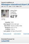
Wilmington only reports every hour bur they just passed TS force gust
Awesome did not know that existed. Look like their highest gust is 47. The airport is about 6 miles northeast of meShag, check out this link. Simply change the last 4 code of nearest airport in your browser.. Updates every 5-10 minutes. Pretty cool.
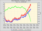
 Wind Direction (WDIR): Wind Direction (WDIR): | N ( 350 deg true ) |
| Wind Speed (WSPD): | 40.8 kts |
| Wind Gust (GST): | 50.5 kts |
| Atmospheric Pressure (PRES): | 29.49 in |
| Air Temperature (ATMP): | 72.0 °F |
| Water Temperature (WTMP): | 80.2 °F |
| Dew Point (DEWP): | 69.8 °F |
| Wind Speed at 10 meters (WSPD10M): | 44.7 kts |
| Wind Speed at 20 meters (WSPD20M): | 48.6 kts |
.thumb.png.a47b732e64ba6aae6d30014e42569f29.png)