Shaggy
Member
Any better defined map?
Any better defined map?
I stole it from JB lolAny better defined map?
Looking like Swansboro might be a good spot for the landfall. Winds have stiffened but still lretty quiet hereLooks to be trying to wrap up and stack up. Going to be an interesting 24 hours.
Impressive really. 30 hrs ago it was 1012, now 987 and will probably drop some moreLooks to be trying to wrap up and stack up. Going to be an interesting 24 hours.

OVER 29C water now
I guess they are waiting for recon data whether to go to a warningHurricane watches up now

gusty here tooI just woke up and they have not called off 3rd shift at the plant tonight lol...really do not wanna go to work at 11pm with this thing coming in. The first time the power blips they will send us all home in the middle of whatever this ends up being around here.
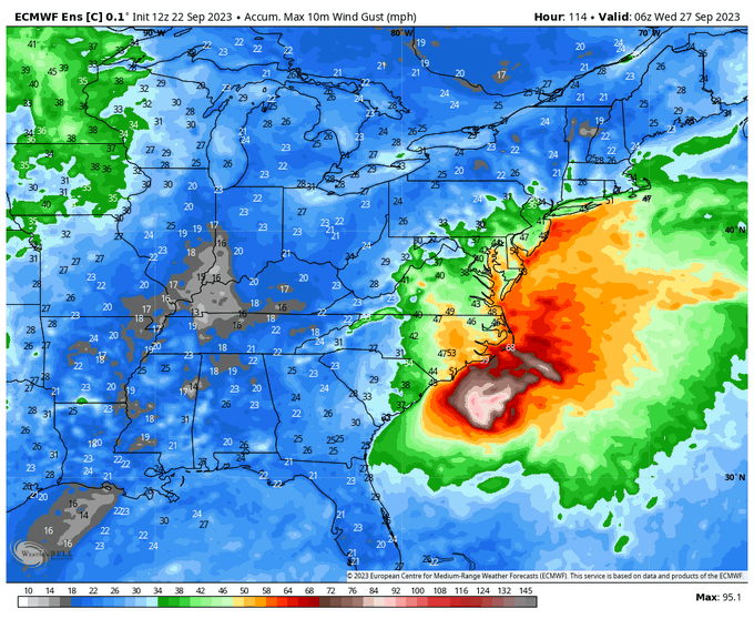
Latest 3k nam this is in knts so 60+ mph gust in places
View attachment 137139
Starting to think I've had a few gusts mod 30s for sure. Models suggest our best shows up in the 3-6 hoursgusty here too
Got down to 983.8 mb. So a ~3 mb drop/pass. Pretty impressive pressure fall.Starting to think I've had a few gusts mod 30s for sure. Models suggest our best shows up in the 3-6 hours
12Z euro had 60 mph gusts inlandNone of the models are really much for inland winds though outside the 3K, never more than 45 or so for most everyone US 1 to the east except for the OBX and southern beaches, and places on the IBX....probably not going to be enough time for the wind field to mature enough to actually get some better gust down.
No, they have recon data, they aren't forecasting it to reach hurricane strength but issued the watch due to the potential that it may do so. It has strengthened quicker than expected so they err on the side of caution, read their discussion, good info in thereI guess they are waiting for recon data whether to go to a warning
 Wind Direction (WDIR): Wind Direction (WDIR): | N ( 10 deg true ) |
| Wind Speed (WSPD): | 38.9 kts |
| Wind Gust (GST): | 58.3 kts |
A little surprised- it has begun gathering tropical characteristics but ophelia is still very much a hybrid phenomena. highest winds are still well away from the center- and a lot of the deepening can be attributed to extratropical processes. Recon shows the pressure gradient is pretty light: Generally guessing the hurricane watches are up since impacts would mimic a minimal cat 1, wind and surge wise (surge may actually be surprisingly high given large wind field and concave shape of coast)I guess they are waiting for recon data whether to go to a warning

| Wind Speed | N 24 G 29 mph |
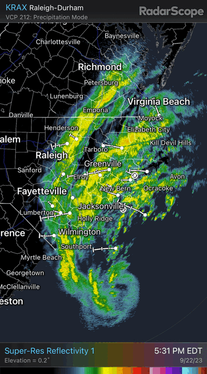
Yeah… the last hour or so, the satellite certainly looks like it’s developing a pretty healthy core around the center. Taking more of a tropical look to it.Center moved SW, tuck right under that deep convection, let's see if it can surprise in the 11th hour
Yep, looking solid on radar, might be a good thing it's gonna run out of room/timeYeah… the last hour or so, the satellite certainly looks like it’s developing a pretty healthy core around the center. Taking more of a tropical look to it.

With the gradient some places will have a cat2 surgeCould see some impressive surge levels given the angle of the approach...might get 5-7 ft in washington
New Bern gonna get it good too....
 , low level clouds are screaming by already and I can hear the roar of the wind inside.....the center is still 200 miles south of me. Got to think we can get some gust 45-55 by the time its all said and done...
| 22 | 17:45 | N 24 G 36 | 5.00 | Rain and Breezy | BKN012 BKN042 OVC100 | 66 | 66 | 100% | NA | NA | 29.88 | NA | 0.07 | ||||
| 22 | 17:25 | NE 26 G 37 | 4.00 | Heavy Rain and Windy | OVC010 | 66 | 66 | 100% | NA | NA | 29.90 | NA | 0.03 |
GDR GST5:50 pmNE ( 40 deg )61 ktsThey have a wierd funnelling effect thereAlready have gusts to 47 at Virginia Beach and 46 at Wallops Island which is pretty far North.
Recon is picking up some 983s on current pass