Snowflowxxl
Member
I'm starting to doubt this thing reaches hurricane status
I'm starting to doubt this thing reaches hurricane status

Center is a mess so far
Aren't weaker storms with no real circulation, (remnants?), supposed to be heavier when we talk about rainfall amounts? They just kinda meander slowly?
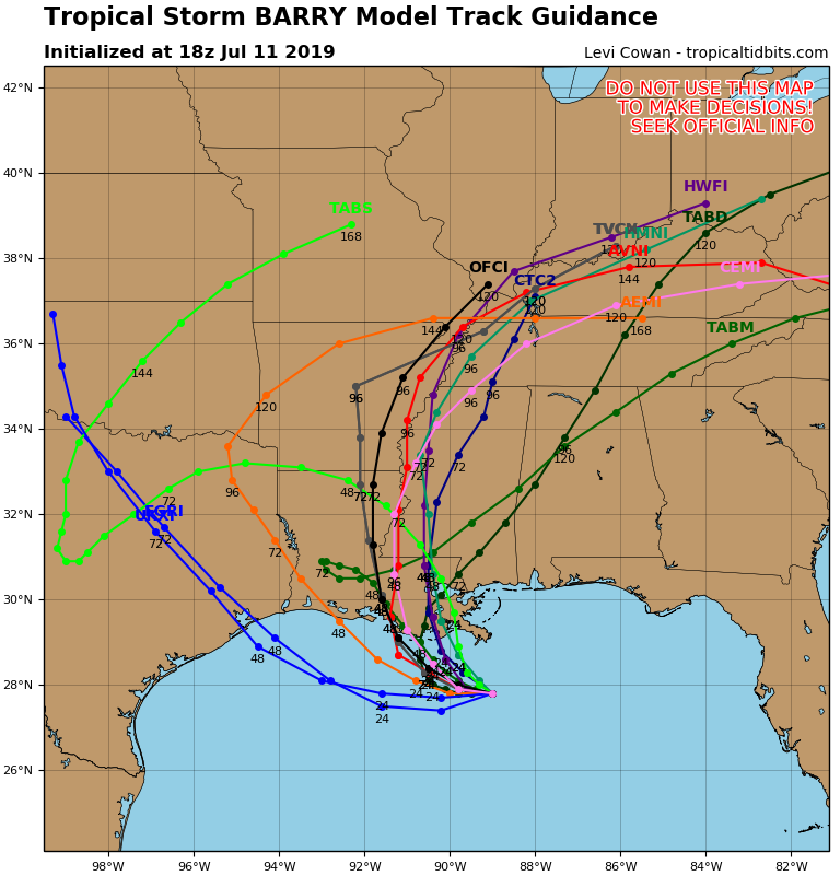
 euro has meanwhile settled on the east side
What a headacheMeanwhile the gfs ensembles shifted west
What's it down to ?pressure is dropping now per recon will it last?
The last pass showed the pressure going to 999 mb.What's it down to ?
The last pass showed the pressure going to 999 mb.

Storm is no longer forecasted to become a hurricane according to the latest advisory.
While not explicitly shown in the
forecast, there is a significant chance that Barry will be a
hurricane when it makes landfall between 36-48 h in agreement with
the HWRF and GFS models.
It's a race to see whether it can reach land before it becomes a hurricane. It all comes down to track and speed. If the west tracks are right, then it just might get there.Very disorganized and with the time and proximity to land I could see this staying below hurricane strength....at the same time it's in some.pretty warm water and a sustained convective blowup could jump it up quickly.
It's a race to see whether it can reach land before it becomes a hurricane. It all comes down to track and speed. If the west tracks are right, then it just might get there.
recon finding 40-45 kt winds now
But yeah I don't think a hurricane is guaranteed by any means
So. Was gfs closer to reality with a very weak storm?
Seems euro was more off than gfs was
Check the member map. Not everyone posts. There’s more over at Cat 6 blog in your area (weather underground).Random question. Am I the only member here in the path of Barry, besides those who get some rain in MS and AL?
It's not a problem. I do enjoy the discussions and community spirit with my fellow southern weather nerds in all our storms and weather events. I was just a little curious is all.Check the member map. Not everyone posts. There’s more over at Cat 6 blog in your area (weather underground).

Do they realize that the NAM is not a very good tropical model?My local mets at WAFB keep showing the NAM model, lol. That's literally the worst case model I've seen today!
Is the HRRR one of the better short range models vs the NAM?