-
Hello, please take a minute to check out our awesome content, contributed by the wonderful members of our community. We hope you'll add your own thoughts and opinions by making a free account!
You are using an out of date browser. It may not display this or other websites correctly.
You should upgrade or use an alternative browser.
You should upgrade or use an alternative browser.
Tropical Tropical Storm Barry
- Thread starter accu35
- Start date


HWRF and HMON models seem to be correcting west again with the 18Z run. I don't think we'll get more accurate model forecasts until we have data input in from the Hurricane Hunters, as well as a LL circulation.

accu35
Member
Thanks man, I'm talking about landfall 12z at landfall was east.Actually the Euro is a tick west of 0z. FWIW there probably isnt really isnt a "east" trend. I think the implications of the models showing the center forming more north or south is where some of them are getting this noise from. Obviously that will determine where exactly the landfall occurs.
HWRF and HMON models seem to be correcting west again with the 18Z run. I don't think we'll get more accurate model forecasts until we have data input in from the Hurricane Hunters, as well as a LL circulation.
Bingo. The landfall point will be affected 100 miles easily in either direction just from where the LLC actually forms and the shape of the coastline.
pcbjr
Member
much less until there is a storm with a name ... the name comes with a degree of intensity and certainty not associated with a LHWRF and HMON models seem to be correcting west again with the 18Z run. I don't think we'll get more accurate model forecasts until we have data input in from the Hurricane Hunters, as well as a LL circulation.
Brent
Member
HWRF and HMON models seem to be correcting west again with the 18Z run. I don't think we'll get more accurate model forecasts until we have data input in from the Hurricane Hunters, as well as a LL circulation.
its all a guess until we know where the center is(which it doesn't have so the models are just assuming stuff), that's why I don't get too worked up over this west vs. east trend, its gonna change
Nice banding getting better defined on the southern side of PTC 2. I'd be surprised if we don't have TS Barry tonight if today's trends keep up.
pcbjr
Member
you wanna go quail hunting with me sometime? we do have a similar look on where something may be found ...its all a guess until we know where the center is(which it doesn't have so the models are just assuming stuff), that's why I don't get too worked up over this west vs. east trend, its gonna change
")
Z
Zander98al
Guest
Any reports from the planes that were supposed to gather data on the storm?
Brent
Member
Any reports from the planes that were supposed to gather data on the storm?
No closed low yet though it has gotten closer
Z
Zander98al
Guest
Probably will be by later tonight early tommrow morning im guessing. Idk if the HRRR is good with tropical stuff but it shows it getting its act together very soon.No closed low yet though it has gotten closer
Brent
Member
Probably will be by later tonight early tommrow morning im guessing. Idk if the HRRR is good with tropical stuff but it shows it getting its act together very soon.
yeah that's my belief too, they should be back out while most are sleeping tonight
currently a higher altitude flight for models I guess
Brent
Member
Interesting pressure dropped 4 mb that pass
Probably will be by later tonight early tommrow morning im guessing. Idk if the HRRR is good with tropical stuff but it shows it getting its act together very soon.
Unless something has changed, I dont think it is. I think it used to have the same issues as the 3km NAM.
Levi just posted a new video:
Z
Zander98al
Guest
Where are you seeing this data/info?Interesting pressure dropped 4 mb that pass
pcbjr
Member
Not sure where Brent is getting info, but ... in your Wiki is this, which should provide good data as you may need and/or want ... http://tropicalatlantic.com/recon/mWhere are you seeing this data/info?
~~~~~~~~~
https://wiki.southernwx.com/doku.php?id=tropical_models
Z
Zander98al
Guest
Thanks! ?Not sure where Brent is getting info, but ... in your Wiki is this, which should provide good data as you may need and/or want ... http://tropicalatlantic.com/recon/m
~~~~~~~~~
https://wiki.southernwx.com/doku.php?id=tropical_models
Well I've stocked up on extra batteries and some more bottled water. I also bought a battery powered fan, which should come in handy if I have to sleep through a power outage night or two. I've been through a few storms in the 2000s that knocked out power for more than a day. Sleeping, even with the windows all open, is no fun in those situations.
pcbjr
Member
Two thumbs up and a "Like" ...no fun
accu35
Member
accu35
Member

Looks like there's a front or MCS complex over AR and OK coming down.looking better
Z
Zander98al
Guest
That video that was posted above talks about how those dying mcs's can aid or hurt tropical development. Will be intresting to see. And that spaghetti plot makes it look like landfall over east LA is likelyLooks like there's a front or MCS complex over AR and OK coming down.
NAM quite a bit east this run so far
B
Brick Tamland
Guest
Mike Maze at WRAL said New Orleans could see historical flooding.
NWMSGuy
Member
Both GFS and EURO bringing good rains to North MS in latest runs. Will be interesting to see how this plays out for everyone.
NAM took a hard turn south at hour 51
Z
Zander98al
Guest
The HRRR and NAM have it go south a little and kindve stall before moving north which would be bad giving it more time.NAM took a hard turn south at hour 51
Snowflowxxl
Member
NAM is leap froggin around the coast, flooding for everyone!!!!
BHS1975
Member
What if it just rakes the coast from NO to Houston.
Sent from my iPhone using Tapatalk
Sent from my iPhone using Tapatalk
Brent
Member
...SYSTEM IS ALMOST A TROPICAL DEPRESSION...
Z
Zander98al
Guest
Where do you see this?...SYSTEM IS ALMOST A TROPICAL DEPRESSION...
Snowflowxxl
Member
3K NAM is only 936MB this run. Epic biblical Hurricane cancelled.
Brent
Member

Brent
Member
3K NAM is only 936MB this run. Epic biblical Hurricane cancelled.
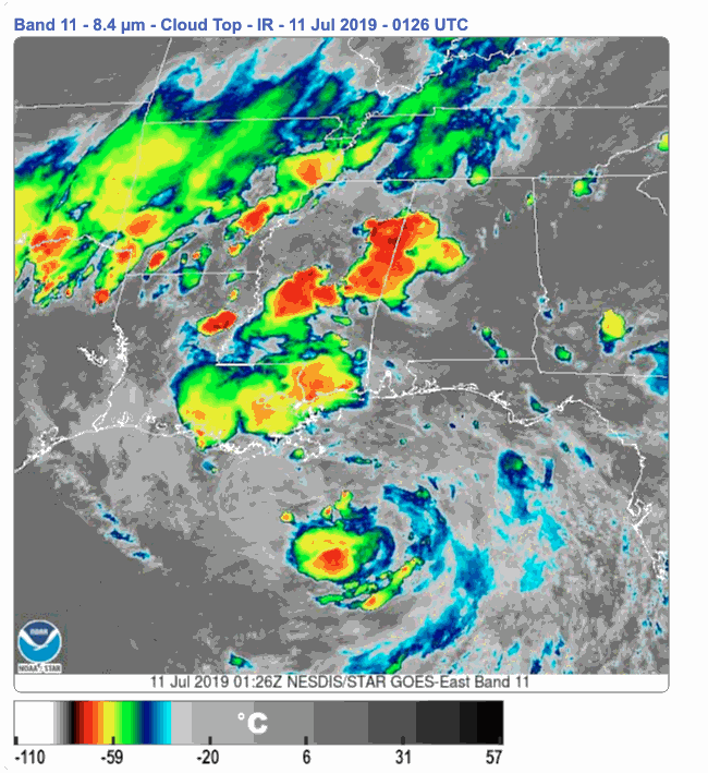
That satellite tho

Z
Zander98al
Guest
The cone has been shifted east some from earlier and then the new one. 
