B
Brick Tamland
Guest
I think the barely cat 1 hurricane on the ICON is a bit more believable than the NAM.
With subsidence, yes! I-2 feet of that!GFS (and legacy) really burry the western Carolinas and north Georgia.

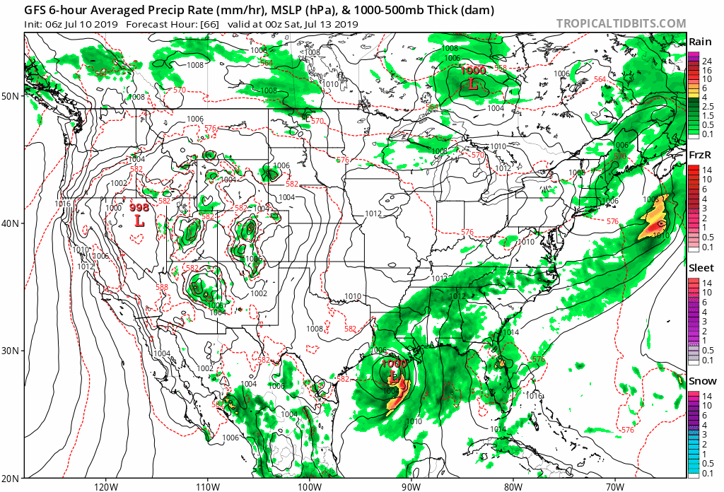

NEW TROPICAL CYCLONE FORECAST TO DEVELOP AFTER 24 HOURS
FORECAST POSITION AT T+ 24 : 27.8N 89.6W
LEAD CENTRAL MAXIMUM WIND
VERIFYING TIME TIME POSITION PRESSURE (MB) SPEED (KNOTS)
-------------- ---- -------- ------------- -------------
1200UTC 11.07.2019 24 27.8N 89.6W 1006 33
0000UTC 12.07.2019 36 27.5N 90.7W 997 41
1200UTC 12.07.2019 48 27.2N 92.6W 987 63
0000UTC 13.07.2019 60 27.5N 94.0W 972 72
1200UTC 13.07.2019 72 28.4N 95.2W 947 88
0000UTC 14.07.2019 84 29.7N 96.3W 965 52
1200UTC 14.07.2019 96 31.3N 97.3W 976 47
0000UTC 15.07.2019 108 32.7N 99.0W 984 37
1200UTC 15.07.2019 120 33.9N 100.1W 993 34
0000UTC 16.07.2019 132 35.2N 101.3W 997 30
1200UTC 16.07.2019 144 36.9N 101.0W 997 33


You'll get your typical afternoon thunderstorm chances, don't worry. NC too far away from center for direct effects.Not saying the GFS is right but some said we could not see any rain from this. Nothing has changed at this preliminary stage, it’s too soon to know.
You use science??Not even a tropical depression and people wanna know landfall location and strength. Science isn’t there yet. No consensus or trend to watch atm other than formation.
If I was in the Carolinas right now I would make sure you keep a full tank of gas. 77% of the refineries are going to be in the path of this hurricane near Louisiana/Texas. Prices gonna explode.You'll get your typical afternoon thunderstorm chances, don't worry. NC too far away from center for direct effects.
Why just the Carolinas? Don't you mean everyone in the SE?If I was in the Carolinas right now I would make sure you keep a full tank of gas. 77% of the refineries are going to be in the path of this hurricane near Louisiana/Texas. Prices gonna explode.
I hope those refineries can hold up under tropical storm wind gusts and heavy downpours!If I was in the Carolinas right now I would make sure you keep a full tank of gas. 77% of the refineries are going to be in the path of this hurricane near Louisiana/Texas. Prices gonna explode.
Social media FTL.Not even a tropical depression and people wanna know landfall location and strength. Science isn’t there yet. No consensus or trend to watch atm other than formation.
The 12Z GEFS mean says that the 12Z GFS is an eastern outlier.
Well the HWRF is showing it to be a very strong cat 2 when it impacts NOLA. I think that a near major plus the flooding would be a recipe for disaster. Let's hope it doesn't happen.Biggest question to me is if the surge up the Mississippi River is at or above 4 feet. That's current pre-lim forecast and if it does occur with the river already above 16 feet flood stage, all the river levees will be topped in NO. The pumps can pump 1 inch rain out in 1st hr and only .5 hour 2. So surge of 4 foot or more up river and rainfall rates inch per hour, is a recipe for big trouble. The levees start being topped at 19.5-20 feet
Biggest question to me is if the surge up the Mississippi River is at or above 4 feet. That's current pre-lim forecast and if it does occur with the river already above 16 feet flood stage, all the river levees will be topped in NO. The pumps can pump 1 inch rain out in 1st hr and only .5 hour 2. So surge of 4 foot or more up river and rainfall rates inch per hour, is a recipe for big trouble. The levees start being topped at 19.5-20 feet
what a shift east
NO needs to learn from the mistakes of the past and raise levees and increase pump capacity. Hoping won't stop the inevitable. Tropical rains will always threaten, and cyclones will hit NO. They must plan ahead or relocate to higher ground. I hope they learn their lesson , this time! It's already flooding in their streets!Well the HWRF is showing it to be a very strong cat 2 when it impacts NOLA. I think that a near major plus the flooding would be a recipe for disaster. Let's hope it doesn't happen.


