-
Hello, please take a minute to check out our awesome content, contributed by the wonderful members of our community. We hope you'll add your own thoughts and opinions by making a free account!
You are using an out of date browser. It may not display this or other websites correctly.
You should upgrade or use an alternative browser.
You should upgrade or use an alternative browser.
Pattern The Great December Dump
- Thread starter Rain Cold
- Start date
This is going to be a long winter if YOU already taking what the GFS is showing post day 10 verbatim???It did nail that December storm right?
Sent from my iPhone using Tapatalk
NoSnowATL
Member
This is going to be a long winter if YOU already taking what the GFS is showing post day 10 verbatim
Yep because that’s what I do. You’re so right.

Sent from my iPhone using Tapatalk
I guess if the current solution above change on 0z Gfs from the above solution..everyone will be on here saying IT WILL BE BACK? I love Southernwx forum but I can’t get how you guys do this every year. ?Yep because that’s what I do. You’re so right.
Sent from my iPhone using Tapatalk
Fwiw it looks like the GEFS is agreeing with the GFS. I already know not gonna happen just putting it out there
View attachment 26837
Some wild ones.

Thanks! If things continue to look promising, I want to start the thread if nobody beats me to it.
Sent from my SM-A102U using Tapatalk
I love clown maps as much as the next guy but that’s got to be ice for those east. No way do you get two foot totals cutting northeast through the heart of Tennessee then get a foot in north and South Carolina ?? ?
?
NoSnowATL
Member
I guess if the current solution above change on 0z Gfs from the above solution..everyone will be on here saying IT WILL BE BACKI love Southernwx forum but I can’t get how you guys do this every year.

I have a secret, most of the time we are just joking.
Sent from my iPhone using Tapatalk
Jessy89
Member
I just hope the people canceling winter is paying attention. Gfs says lights out for most of upstate sc. parts of Georgia.
Sent from my iPhone using Tapatalk
Sent from my iPhone using Tapatalk
NBAcentel
Member
I just hope the people canceling winter is paying attention. Gfs says lights out for most of upstate sc. parts of Georgia.
Sent from my iPhone using Tapatalk
It’s wayyy out there and extremely unlikely, past 300 hours
I'm not jumping ahead to that system just yet. I'm focusing on the 10th-11th time period for the possibility of a significant snow storm.I just hope the people canceling winter is paying attention. Gfs says lights out for most of upstate sc. parts of Georgia.
Sent from my iPhone using Tapatalk
Sent from my SM-A102U using Tapatalk
Yes specifics this far out should not be looked at .. but one can’t ignore the fact that the pattern looks to be setting up for some sort of ice event in the medium range ... certainly wouldn’t put any more stock into anything more than that.. more than likely an ice event with the big clashes of air masses and the warmth in the upper levels we will see with a huge cold high filtering in dry cold air at the surface ... recipe for fun... I mean trouble ...
Color me in the cancelled December department. Comments saying lights out for something far out is a bit overkill. I don’t live by the model run or one particular model. It’s a bit quiet in here for a reason; no true wintry pattern exists in the short to mid range for the Carolinas east of the mtns.I just hope the people canceling winter is paying attention. Gfs says lights out for most of upstate sc. parts of Georgia.
Sent from my iPhone using Tapatalk
So you think we get skunked for December?Color me in the cancelled December department. Comments saying lights out for something far out is a bit overkill. I don’t live by the model run or one particular model. It’s a bit quiet in here for a reason; no true wintry pattern exists in the short to mid range for the Carolinas east of the mtns.
NoSnowATL
Member
Color me in the cancelled December department. Comments saying lights out for something far out is a bit overkill. I don’t live by the model run or one particular model. It’s a bit quiet in here for a reason; no true wintry pattern exists in the short to mid range for the Carolinas east of the mtns.
You do understand the lights out comment is in the BS thread right? We understand it’s not going to happen but it kills time and pretty to look at.
Sent from my iPhone using Tapatalk
Jessy89
Member
Color me in the cancelled December department. Comments saying lights out for something far out is a bit overkill. I don’t live by the model run or one particular model. It’s a bit quiet in here for a reason; no true wintry pattern exists in the short to mid range for the Carolinas east of the mtns.
Can we just take it a model run at a time. Right now the possibility of a ice storm is on the table. Will it happen 80 percent no. But we should at least say it’s December so it’s at least possible.
Sent from my iPhone using Tapatalk
You guys, I know models look good, but, I'm still going to stay consistent with a warmer, milder early December.
Why you may ask?
Taking a look at the MJO, as highlighted in a previous post https://southernwx.com/community/threads/the-great-december-dump.650/page-5#post-212237
Still looking at the latest runs, the same thing with a standing wave between 30-60 degrees E.
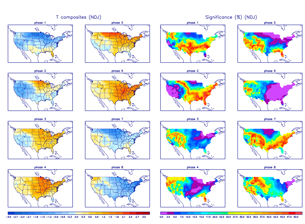
This is largely supporting a phase 3 pattern. As long as that wave is there, we shouldn't move into the warmer phases so that is good.
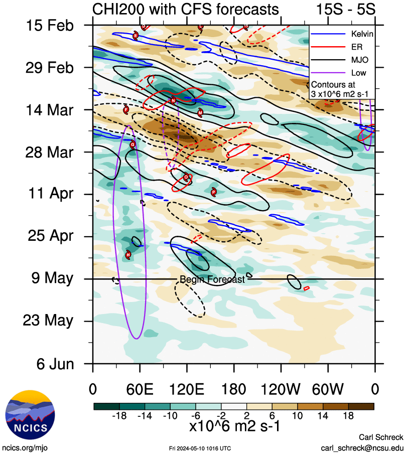
Phase 3 is a blowtorch but isn't crazy
850s aren't beautiful, map courtesy of Webb's previous post https://southernwx.com/community/threads/nippy-november.639/page-68#post-211062
Why you may ask?
Taking a look at the MJO, as highlighted in a previous post https://southernwx.com/community/threads/the-great-december-dump.650/page-5#post-212237
Still looking at the latest runs, the same thing with a standing wave between 30-60 degrees E.
This is largely supporting a phase 3 pattern. As long as that wave is there, we shouldn't move into the warmer phases so that is good.

Phase 3 is a blowtorch but isn't crazy

850s aren't beautiful, map courtesy of Webb's previous post https://southernwx.com/community/threads/nippy-november.639/page-68#post-211062

Ilovesnow28
Member
Im not trying to cancel winter in any form or faction but I've been let down to many times and im not expecting anything besides rain and warm temps as usual especially for my part of the area... So I'm not getting happy until i see flakes falling and accumulating.... Not trying to be a debby downer folks carry on
A significant snow storm is looking like a possibility during the 10th-11th time frame (8-9 days away at the time of this post) I have added some important things to look for in the coming days. I do think the convergence point between the polar jet and subtropical jet will trend further south and east. In fact, the convergence point is further south and east on the GFS verses it's 12z run.

When the polar jet and subtropical jet converge, this would trigger convective moisture. Deep cold air would be in place at the same time, so heavy snowfall would occur. Also due to the convergence, very strong upper level winds would occur as well. The convergence is one of the big factors at play that would generate a significant snow event.


When the polar jet and subtropical jet converge, this would trigger convective moisture. Deep cold air would be in place at the same time, so heavy snowfall would occur. Also due to the convergence, very strong upper level winds would occur as well. The convergence is one of the big factors at play that would generate a significant snow event.

Jessy89
Member
A significant snow storm is looking like a possibility during the 10th-11th time frame (8-9 days away at the time of this post) I have added some important things to look for in the coming days. I do think the convergence point between the polar jet and subtropical jet will trend further south and east. In fact, the convergence point is further south and east on the GFS verses it's 12z run.
View attachment 26853
When the polar jet and subtropical jet converge, this would trigger convective moisture. Deep cold air would be in place at the same time, so heavy snowfall would occur. Also due to the convergence, very strong upper level winds would occur as well. The convergence is one of the big factors at play that would generate a significant snow event.
View attachment 26855
Would this bring snow outside the mountains?
Sent from my iPhone using Tapatalk
ForsythSnow
Moderator
I seriously doubt any potential of any snow from this time frame. Not only is that jet stream cherry picked in the ideal position from one run, it's from the GFS and the GFS has a heavy tenancy to be too progressive and cold. Realistically, this will either become a cutter due to the introduction of the SER or it'll be too positive to produce. The latter is most likely.A significant snow storm is looking like a possibility during the 10th-11th time frame (8-9 days away at the time of this post) I have added some important things to look for in the coming days. I do think the convergence point between the polar jet and subtropical jet will trend further south and east. In fact, the convergence point is further south and east on the GFS verses it's 12z run.
View attachment 26853
When the polar jet and subtropical jet converge, this would trigger convective moisture. Deep cold air would be in place at the same time, so heavy snowfall would occur. Also due to the convergence, very strong upper level winds would occur as well. The convergence is one of the big factors at play that would generate a significant snow event.
View attachment 26855
I think the best question to ask is what other models besides the GFS support this. I wouldn't put any stock into this until the Euro is on board.Would this bring snow outside the mountains?
Sent from my iPhone using Tapatalk
Cad Wedge NC
Member
I get what you are saying except for the "deep cold air in place" part....... 850's are above freezing and the surface is near 50 degrees at that time...... For those of us east of the mountains, it looks like just a frontal passage. What areas are you targeting?A significant snow storm is looking like a possibility during the 10th-11th time frame (8-9 days away at the time of this post) I have added some important things to look for in the coming days. I do think the convergence point between the polar jet and subtropical jet will trend further south and east. In fact, the convergence point is further south and east on the GFS verses it's 12z run.
View attachment 26853
When the polar jet and subtropical jet converge, this would trigger convective moisture. Deep cold air would be in place at the same time, so heavy snowfall would occur. Also due to the convergence, very strong upper level winds would occur as well. The convergence is one of the big factors at play that would generate a significant snow event.
View attachment 26855
This guys is the best... one second I’m reading thinking all hope is doomed then I hit one of ur posts and I’m about damn sure we’re about to get a snow storm... for real tho I love ur analysis and constant updates ... it keeps me alive in this thread sometimesA significant snow storm is looking like a possibility during the 10th-11th time frame (8-9 days away at the time of this post) I have added some important things to look for in the coming days. I do think the convergence point between the polar jet and subtropical jet will trend further south and east. In fact, the convergence point is further south and east on the GFS verses it's 12z run.
View attachment 26853
When the polar jet and subtropical jet converge, this would trigger convective moisture. Deep cold air would be in place at the same time, so heavy snowfall would occur. Also due to the convergence, very strong upper level winds would occur as well. The convergence is one of the big factors at play that would generate a significant snow event.
View attachment 26855
GeorgiaGirl
Member
I went outside today without protection for my ears from the wind, that was a mistake as it was so windy and dry that my ears began to hurt from it.
The air temp wasn't that cold though this afternoon.
The air temp wasn't that cold though this afternoon.
Yes, that set-up would bring snow outside of the mountains.Would this bring snow outside the mountains?
Sent from my iPhone using Tapatalk
Sent from my SM-A102U using Tapatalk
At this stage, I'm not focusing on 850 temps or surface temps. Right now, it's in the upper-level trend stage. Whatever happens in the upper level's will differentiate what happens at the surface.I get what you are saying except for the "deep cold air in place" part....... 850's are above freezing and the surface is near 50 degrees at that time...... For those of us east of the mountains, it looks like just a frontal passage. What areas are you targeting?
Sent from my SM-A102U using Tapatalk
“ I’ve scored off of that look 100 times!”I'll take "No way it can cut with that high pressure there" for $1000.
Seriously, when was the last time the GFS was right, dropping a nearly 1050 high into the midwest? I wish it would nail one for once.
Don’t sleep on December! You might miss some cool rains, and maybe some cold ones!?So you think we get skunked for December?
ForsythSnow
Moderator
If the temps aren't remotely close why even bother looking at it? If it was in the 30s then maybe but 50s can't change easily without uprooting the entire pattern modeled.At this stage, I'm not focusing on 850 temps or surface temps. Right now, it's in the upper-level trend stage. Whatever happens in the upper level's will differentiate what happens at the surface.
Sent from my SM-A102U using Tapatalk
Trim your trees and your roof! WxSouth is starting to go cooler on his winter thoughts, I believe. Saying who cares about December, but 2 out of 3 winter months will be below normal, not sure on which 2! Posted on FB
So did DT ever do a final winter outlook? Or did he just tease it and then pretend that he never said anything about it? Maybe he wants to get through December and do it for calendar winter only?
He’s been a bit under the weather lately, really!So did DT ever do a final winter outlook? Or did he just tease it and then pretend that he never said anything about it? Maybe he wants to get through December and do it for calendar winter only?
Robert has really went downhill lately. Can’t believe he posted that over inflated snow map for the mountain event that just occurred on his FB. And he says things like 6-8 warm weeks are not likely....umm idk about most of y’all but I’ve never seen that long of a heat wave in the winter here. He needs money badly.Trim your trees and your roof! WxSouth is starting to go cooler on his winter thoughts, I believe. Saying who cares about December, but 2 out of 3 winter months will be below normal, not sure on which 2! Posted on FB
Maybe someone on here with more knowledge than me can answer this, but when was the last time that the southeast ridge has been held in check this long. It seems like it hasn’t been as big a player in the overall pattern for the last month and I don’t recall anytime over the last few years that could be said. It’s shown up on some ensemble runs around the 10-12 day period but goes away closer to verification
RollTide18
Member
A reminder that parts of Alabama got a foot of snow in December two years ago, while the month as a whole may not be cold & stormy or have a perfect pattern, it only takes one instance of all the ingredients mixing together for someone to score.


 I love Southernwx forum but I can’t get how you guys do this every year.


