May and September are summer months in the south IMO. I would even consider April and October summer months in FL.Or May for that matter (how soon we forget, it was also the warmest on record).
If nothing else, we can certainly say this has been a long Summer, with a growing season that started way back in February.
-
Hello, please take a minute to check out our awesome content, contributed by the wonderful members of our community. We hope you'll add your own thoughts and opinions by making a free account!
You are using an out of date browser. It may not display this or other websites correctly.
You should upgrade or use an alternative browser.
You should upgrade or use an alternative browser.
Pattern Scorchtember
- Thread starter SD
- Start date
May and September are summer months in the south IMO. I would even consider April and October summer months in FL.
If they weren't traditionally, they are now.
I suspect the new 30-year averages to be released will reflect that, as this decade in general has been a torch.
pcbjr
Member
They tend to work in roughly 20 year cycles ... give or take ...If they weren't traditionally, they are now.
I suspect the new 30-year averages to be released will reflect that, as this decade in general has been a torch.
They tend to work in roughly 20 year cycles ... give or take ...
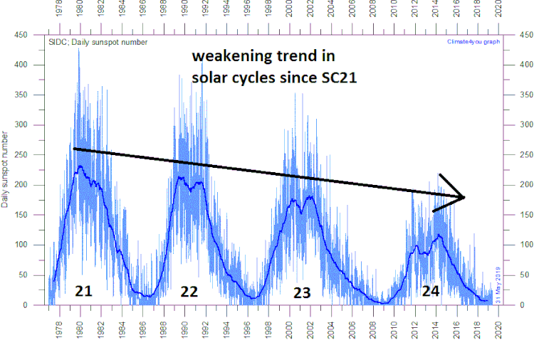
What's really crazy though is this persistent pattern of above average temps is occurring at a time of supposed Solar Minimum...
https://www.climatedepot.com/2019/0...inimum-may-be-the-weakest-cycle-in-200-years/
NoSnowATL
Member
What's really crazy though is this persistent pattern of above average temps is occurring at a time of supposed Solar Minimum...
https://www.climatedepot.com/2019/0...inimum-may-be-the-weakest-cycle-in-200-years/
Starting to think it doesn’t effect as much as we thought.
Sent from my iPhone using Tapatalk
The Happy Hour GFS has 95 at KATL on 10/3! Are we going to need a Hotober thread? Gosh, I hope not!
Meanwhile, I’m doing my walk outside for the first time in months! It’s actually halfway pleasant and it has been so much better the last couple of days than it had been for several months!
Meanwhile, I’m doing my walk outside for the first time in months! It’s actually halfway pleasant and it has been so much better the last couple of days than it had been for several months!
tennessee storm
Member
We should name it octane October ... lolThe Happy Hour GFS has 95 at KATL on 10/3! Are we going to need a Hotober thread? Gosh, I hope not!
Meanwhile, I’m doing my walk outside for the first time in months! It’s actually halfway pleasant and it has been so much better the last couple of days than it had been for several months!
Make it stop
The heat is trapped in the oceans. Or something..??What's really crazy though is this persistent pattern of above average temps is occurring at a time of supposed Solar Minimum...
https://www.climatedepot.com/2019/0...inimum-may-be-the-weakest-cycle-in-200-years/

pcbjr
Member
I'll file a Motion to Abate on your behalf ... pro bono ...The heat is trapped in the oceans. Or something..??
")
Downeastnc
Member
Speaking of severe weather, when the ridge does crash, it’s obviously gonna take a trough to dig and do so, and a strong one at that, which obviously means high shear parameters, just instability is the question with fall setups, only takes 200>JKG as we’ve seen a lot of HSLC events in fall in the past, but this is something that is just a possibility and something the models aren’t even picking up
There have been some memorable squall lines in my neck of the woods at least in Nov, and there is a bit of a tornado peak in the SE in Nov...NC has had several large killer Nov tornados over the years.....and the longest tracked tornado ( 160 miles ) was Nov 22 1992.
B
Brick Tamland
Guest
There have been some memorable squall lines in my neck of the woods at least in Nov, and there is a bit of a tornado peak in the SE in Nov...NC has had several large killer Nov tornados over the years.....and the longest tracked tornado ( 160 miles ) was Nov 22 1992.
I think NC leads the nation in tornado deaths in November, too. For some reason it seems to happen the week of Thanksgiving.
ATLwxfan
Member
Make it stopView attachment 23819
We’ve known it was going to be hot on 9/30. It’s no surprise that we are still seeing that look. Just hope these tropical systems will eventually help break the ridge (with minimal damage to person and property).
Sent from my iPhone using Tapatalk
accu35
Member
You would think with all these TC that the ridge will break at some point.
Brent
Member
I swear I keep looking for change and October is next week and still waiting...
just think of all the record highs though
just think of all the record highs though
tennessee storm
Member
Ridge is to strong ... that’s keeping them out to sea ... pretty muchYou would think with all these TC that the ridge will break at some point.
ATLwxfan
Member
Thankfully the ridge weakens considerably towards the end of the 06z GFS run. Most of us will welcome low 80’s at that point.
Sent from my iPhone using Tapatalk
Sent from my iPhone using Tapatalk
ATLwxfan
Member
I swear I keep looking for change and October is next week and still waiting...
just think of all the record highs though
By the looks of things it may be October 15th or so before anything near normal or below.
Sent from my iPhone using Tapatalk
tennessee storm
Member
Unfortunately it’s the gfs now ... 6z is the worst gfs run also. 12z starts showing it ... maybeThankfully the ridge weakens considerably towards the end of the 06z GFS run. Most of us will welcome low 80’s at that point.
Sent from my iPhone using Tapatalk
SWVAwxfan
Member
Didn't Raleigh NC have a killer nighttime tornado back in Nov 1988? Ok. It was indeed on Nov 28th, 1988. NC is notorious for nocturnal tornadoes.
NBAcentel
Member
Didn't Raleigh NC have a killer nighttime tornado back in Nov 1988? Ok. It was indeed on Nov 28th, 1988. NC is notorious for nocturnal tornadoes.
Notorious for wedge front setup tornadoes at night, especially where SRH is maxed out and 100-500 jkg of CAPE manage to sneak in, 1 example is March 2012
SWVAwxfan
Member
You would need a very powerful hurricane coming out of the Gulf to smack that ridge in its backside. Only other hope is a very powerful continental storm system with a strong, digging troft to knock it out of the way.
SWVAwxfan
Member
Which would be a concern this year with all the backdoor fronts. One of those could spell big trouble for NC.
Today's high was 90*F here, while it was 88*F at ATL.
Storm5
Member
Happy first week of fall . Enjoy the heat !!
Sent from my iPhone using Tapatalk
Sent from my iPhone using Tapatalk
Today's high was 90*F here, while it was 88*F at ATL.
I had 58.8 this morning, I don't recall that being forecast. What was it down there?
I had 58.8 this morning, I don't recall that being forecast. What was it down there?
62*F.
gawxnative
Member
Got to 57.8 here this morning.. Nice!62*F.
Nashville has had 90 days of 90+ this year. That puts 2019 2nd behind only 1954 when there were 96 days.
Barring a surprise shift in the outlook for the next 7 days, we here at GSP will finish the month of September with 28/30 days with an above average high temperature.
Today's high was 92*F here and 91*F at ATL.
B
Brick Tamland
Guest
A dry spell is what the doctor ordered for Wilkes after running 10” above normal year to date. That rain was miserable for months. Lots of damage across western NC.
 And we got color in Watauga.
View attachment 23992And we got color in Watauga.
I believe that's a skid-mark.
Looks like we have some low end rain chances around tomorrow afternoon through Sunday. Don't sleep on the wedge potential late Sunday through Tuesday either. Models are getting that look of building down a wedge with the SE ridge trying to pump ahead of a front.
Sent from my SM-G975U using Tapatalk
Sent from my SM-G975U using Tapatalk
Yeah, in my area, RPM model looks legit Thursday, but not much any other dayLooks like we have some low end rain chances around tomorrow afternoon through Sunday. Don't sleep on the wedge potential late Sunday through Tuesday either. Models are getting that look of building down a wedge with the SE ridge trying to pump ahead of a front.
Sent from my SM-G975U using Tapatalk
Yeah not expecting much but at least we have a catalyst around.Yeah, in my area, RPM model looks legit Thursday, but not much any other day
Sent from my SM-G975U using Tapatalk
Today's high was 94*F here and 92*F at ATL.
FFC shared an interesting fact this morning. As of yesterdat, ATL has seen 82 days of 90*F+ temps (putting it in the top 5 highest number ever in a calendar year).
The highest number ever is 90 days of 90*F+ temps in a calendar year, which seems to be a lock to get broken.
FFC shared an interesting fact this morning. As of yesterdat, ATL has seen 82 days of 90*F+ temps (putting it in the top 5 highest number ever in a calendar year).
The highest number ever is 90 days of 90*F+ temps in a calendar year, which seems to be a lock to get broken.
Omgz

Sent from my SM-G975U using Tapatalk

Sent from my SM-G975U using Tapatalk