NBAcentel
Member
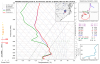
True, but in this case, it doesn't look like it's going to nail the surface temps very well. I'd put some trust upstairs but not so much at the surface, especially when it doesn't really have support from anywhere else. The 18z is going to be less robust with the clown maps due to the lack of precip. Maybe 0z brings the heavier stuff back in.
yeah, this is it, tends to do well with showing SW winds aloft in setups and WAA correctly, but it aint the best at the surface, this storm was never really gonna happen lol