-
Hello, please take a minute to check out our awesome content, contributed by the wonderful members of our community. We hope you'll add your own thoughts and opinions by making a free account!
You are using an out of date browser. It may not display this or other websites correctly.
You should upgrade or use an alternative browser.
You should upgrade or use an alternative browser.
Severe New Year's Week Severe Threat(s)
- Thread starter RBR71
- Start date

Dang dangerous look there.
18z nam and gfs are both a 2 wave event the Tuesday portion has much more backing in the low levels but lacks a little on the instability side and may have an inversion across parts of Al/GA. Wednesday looks much better with sb instability but the wind field gets a little more unidirectional but still slightly backed at the sfc
Locally I think this could be a formidable wind event but I'm not entirely sold on that. We could easily just see a slow moving training line
Darklordsuperstorm
Member
This guy does a fantastic job breaking down what the models are showing. Really gets down into the finer details. Even gets into the discussion of the soundings. You can really learn a lot. He also looks at past events and breaks them down in the same detail.
JHS
Member
Timing looks right for much of NC and SC right now to have at least a wind threat with this. No real sign of CAD with this either, but that could obviously change.Locally I think this could be a formidable wind event but I'm not entirely sold on that. We could easily just see a slow moving training line
12z hrrr had some discrete convection a decent SB Cape values in the warm sector Tuesday afternoon
Line tries to roll linear by Tue morning but this still looks problematic


DadOfJax
Member
He’s back…Zander had a valid point. Yes he may be extreme with some of his outlooks and terminology, but the point he was making is that if whatever is being discussed doesn’t involve the Carolina’s it gets crapped on by a lot of people and discredited. Move this to banter if you feel it is necessary but this is SOUTHERNwx not just CAROLINAwx.
Darklordsuperstorm
Member
Yeah that looks like trouble looks like there is still plenty of development ahead of the main squall line and the squall line itself looks stout!
shortstopsergio
Member
Shame that Zander guy left.. he was the only one making a lot of posts about this event. Would love some more analysis
BHAMWX
Member
Zander kept me up to date with potential bad weather in my area. Get him back, please.
Natedogg25
Member
I agree.. always keeping us Alabama folks with the latest information.Zander kept me up to date with potential bad weather in my area. Get him back, please.
Triplephase93
Member
Shameful he was dismissed by admin. He was one of the few who posted on threats outside of the Carolinas.
Oof 
Heelyes
Member
Come on dude, he quit like a little kid because he didn't like ?Shameful he was dismissed by admin. He was one of the few who posted on threats outside of the Carolinas.
NoSnowATL
Member
PDS sounding for sure.
Triplephase93
Member
Check out the reactions in this thread. I love this site. I visit everyday. Tennessee, Mississippi, Alabama, and Georgia have much different weather than than the Carolinas on any given system. He wasn’t wrong on this system for his area.Come on dude, he quit like a little kid because he didn't like ?
It's really a messy situation once you get east of MS. That initial round late tomorrow intoTuesday looks legit in the area outlined by spc but after that it really throws a monkey wrench downstream into al/GA.
Heelyes
Member
I'm going to quit because I got a fail emoji?Check out the reactions in this thread. I love this site. I visit everyday. Tennessee, Mississippi, Alabama, and Georgia have much different weather than than the Carolinas on any given system. He wasn’t wrong on this system for his area.
Triplephase93
Member
AgreeIt's really a messy situation once you get east of MS. That initial round late tomorrow intoTuesday looks legit in the area outlined by spc but after that it really throws a monkey wrench downstream into al/GA.
What I'm wondering is does the initial line and ofb push out and slow and it becomes more of a catalyst for training heavy rain across Al/GA with occasional spin ups versus a lot of discrete convection.Agree
Triplephase93
Member
Thinking Mississippi sees some rogue tornado possibilities. Straight line winds into Alabama is their biggest threat. I trust you guys analysis though. Light years beyond my comprehension of weather which is why I visit everyday.What I'm wondering is does the initial line and ofb push out and slow and it becomes more of a catalyst for training heavy rain across Al/GA with occasional spin ups versus a lot of discrete convection
BufordWX
Member
I have been noticing that the Euro has been fairly consistent on showing a mass of storms along the gulf coast on Tuesday which would likely rob areas further north of energy. Although I haven’t seen much support of that from other models up to this point (pending 00z runs). I wouldn’t rule it out though.It's really a messy situation once you get east of MS. That initial round late tomorrow intoTuesday looks legit in the area outlined by spc but after that it really throws a monkey wrench downstream into al/GA.
JHS
Member
It looks like a wind threat here in the Carolinas. Looks like a QLCS forms with a few severe gusts possible. Maybe 1 or 2 weak tornados too.
I’m not quite sure that this statement is true. I don’t post much anymore but I do keep up with what’s going on. Just take a look at past severe weather events in areas other than Nc and Sc and who was the most involved. It might not always pan out but the guy loved severe weather. Shame on all of you for belittling him because you might not agree. This was and should be an open forum to ask questions, be opinionated and create dialogue. Not to be ridiculed. I’ve said my peace and will go back quite now. As an old member used to say…Carry on…Come on dude, he quit like a little kid because he didn't like ?
This one is just frustrating tbh since it's not a single wave pushing through and that leaves a ton of question marksThinking Mississippi sees some rogue tornado possibilities. Straight line winds into Alabama is their biggest threat. I trust you guys analysis though. Light years beyond my comprehension of weather which is why I visit everyday.
NoSnowATL
Member
Models can under play the gulf coastal robberies, as former Georgia guys we know how this plays out 9/10 times.I have been noticing that the Euro has been fairly consistent on showing a mass of storms along the gulf coast on Tuesday which would likely rob areas further north of energy. Although I haven’t seen much support of that from other models up to this point (pending 00z runs). I wouldn’t rule it out though.
BufordWX
Member
Absolutely! If this euro depiction is anywhere close to right, I’m not seeing much in the way of severe storms further north Tuesday afternoon.Models can under play the gulf coastal robberies, as former Georgia guys we know how this plays out 9/10 times.

JHS
Member
The 18z Euro has a lot of gulf coast convection at 18z Tuesday. Also not nearly as much precip as earlier models had.
This setup doesn't scream gulf coast convection to me the warm sector is already pushed well north but we will see
Decent 100m SRH
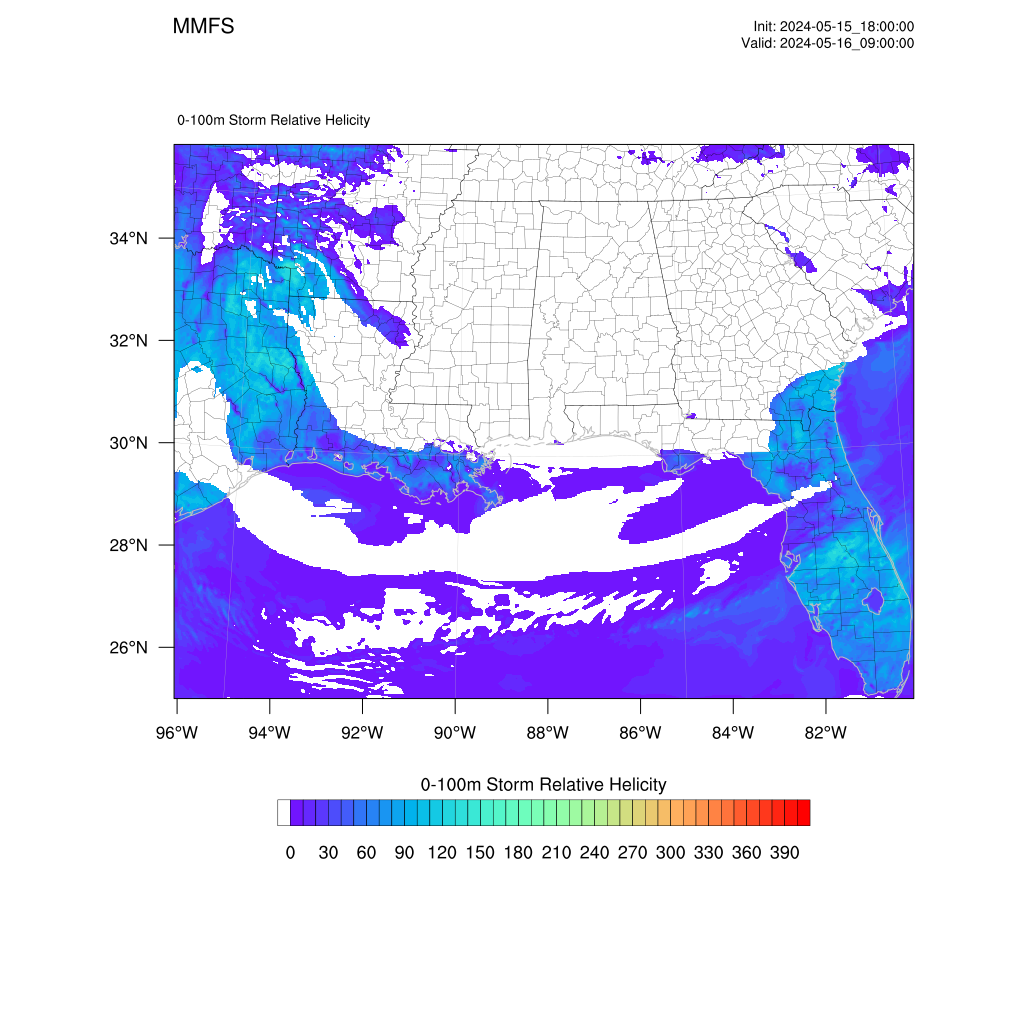
.gif")

Darklordsuperstorm
Member
I'm still on the fence with this one. Short range models are all over the place. Even tomorrow has questions with what could be a very messy storm mode. My gut tells me this will probably be your run of the mill cold season threat. I'm interested in seeing how the details work themselves out over the next 24 hours. The ingredients are there but will they all mix together perfectly remains to be seen.
0Z HRRR UH. Pretty rough run as a whole on the hrrr with the main threat for AL on Tuesday
.png")
From Bham NOAA: forecast discussion
Monday night through next Saturday)
Issued at 1235 PM CST SUN JAN 1 2023
A complicated forecast scenario to kick off the extended period.
Synoptic guidance is somewhat in agreement deepening a surface low
across the Central Plains on Monday. The attendant upper low will
lift northeast toward the Midwest/western Great Lakes on Tuesday.
The surface low begins to fill with time with the attendant
occluded front approaching the region Tuesday night/early
Wednesday.
As the previous forecast discussions have already mentioned, some
competing factors at play here in terms of precipitation
potential and certainly convection - intensity of convection. We
are getting into the window of the CAMs now and they`re really
struggling with initiating/sustaining convection along or ahead of
the front due to very limited forcing and the dynamics lifting
quickly away from the region.
Dewpoints should recover fairly quickly late Monday into early
Tuesday well into the 60s. And deep layer southerly/southwesterly
flow will lead to effective bulk shear of 40-50 knots. Model
soundings show decent mid level lapse rates with MLCAPE generally
500-1250 J/kg. As such, current feelings are that the CAMs are
undergoing the precip and will trend toward the higher PoPs in
the synoptic and blended guidance. As a caveat, there is some hint
of a potential split in development with one area in the
proximity of the front across our far north/northwest and another
in our south/southeast in the vicinity of the higher theta-e and
moisture transport (with a potential minimum somewhere in the
middle). Did not try to get that cute with the spatial extent for
now given we are still 48 hours out.
The other trend with the 12z guidance has been a slight slowing of
the system - particularly when it comes to the sensible weather. Not
sure I`m ready to fully latch on to that solution just yet but did
maintain fairly high PoPs in the southeast through early Wednesday.
The remainder of the forecast looks fairly benign but generally cool
with the thermal trough lingering across the Tennessee Valley
through at least Friday. Some slow warming by next weekend.
Some of the overnight CAMs were pretty rough from Birmingham south tomorrow
Darklordsuperstorm
Member
I'm a little surprised to see that SPC introduced an enhanced area for tomorrow.
12z hrrr was pretty activre in the ENH tomorrow afternoonI'm a little surprised to see that SPC introduced an enhanced area for tomorrow.


