Warm sector really pumping in dews 60+ pushed well north


Is that the default color table or where did you get that one?Warm sector really pumping in dews 60+ pushed well northView attachment 129145
Nah its not the default I believe it's the 2 meter temp color pallette. I'll check when I log back on laterIs that the default color table or where did you get that one?
Thanks. I’ve seen almanydesigns is back up running and has added more tables.Nah its not the default I believe it's the 2 meter temp color pallette. I'll check when I log back on later


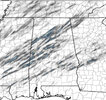
Lots of junk convection competing with the storms today. This was one of the things that was mentioned as being able to possibly keep a lid on things. So far that has been the case outside of a few quick spinups.Looks like most of the action so far this afternoon has been the band of storms that is moving through west-central into northern Louisiana. Arkansas got pretty worked over by the earlier storms, but still saw there may have been 1 or 2 storms where a brief tornado touched down. Still a few storms further west in Oklahoma, but they seem to be falling apart as they move into the rain cooled air further east.
Same to a degree over here in N GA with many locations with temps near 60/low 60's and DP s very similar.. Even with dynamics moving off to the north, when I stepped outside air has "that feel" to it, CAD has mostly broken down a good bit earlier than progged, so need to be aware today/ this evening.What's going to be interesting is what/how effect the missed forecasts parameters play in today's storms.... The hi-res hodograph soundings for most of the model suites all appear to be between 5-10 degrees off from current temperatures. I don't have access to live dew points, but I can say it's undoubtedly muggy for early January in the A.M. If gulf convection doesn't initiate, this could be an interesting day for most of Alabama. Very interested to see how this plays out! Always been a rule of thumb here, if its 70 degrees, windy, and muggy in winter.... pay attention..guess we'll see if that holds true. Everyone stay safe today!


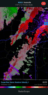
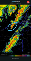
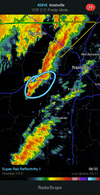
Dissipated nowThat storm south west of Nashville looking like a problem. Had a hook on reflectivity for a short period.
Yeah, I’m not counting on long trackers today. Tornadoes could be strong, but fairly short lived based on looking at the fairly unidirectional wind profiles and SSW winds at the surface.Getting the feeling this is what today will primarily consist of, short lived spin ups trying to get going. Hoping maybe they can't get the upper support they need to become to bad for a large swath with most of the upper level support pushing off quickly to the north?? Maybe? Maybe not? Like a powder keg fully loaded and someone holding A lighter just out of reach to set it off.
You can select the Attach Files button at the bottom, and if you've saved an image to your device, browse to it and upload it. Once you see the image thumbnail that has been uploaded, you can choose to either add it to the post as a thumbnail or full image (preferred). Then, when you post your reply, the image should be included. Hope that helps!I don’t know how to post pictures yet but tornado watch out for all of west Alabama