ATLwxfan
Member


Why could we not get this in Mid January.
It rhymes with Na Liña.
Sent from my iPhone using Tapatalk


Why could we not get this in Mid January.


Why could we not get this in Mid January.
That is also a very real possibilityThis thing is going to suppressed into oblivion at 18z.
Sent from my iPhone using Tapatalk
You’re not wrong in that it’s more rare, but there are exceptions. Certainly northern areas of the SE are more favored, though.This is the thing, March snow happens but most large storms have been within the first few days of March typically. We are getting about a good of an H5 pattern as you want to deliver really cold and well below average temps for a large junk of the month as it looks right now. But even with a large displacement of cold air in the eastern US and 15-20 degree below average temps, it's still going to be in the upper 30's and lower 40's more than likely outside of the mountains. So while yes we keep winter around, it's still not cold enough to snow in unless you get closer to record breaking type cold which is extremely tough to rely on.
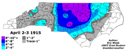
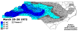
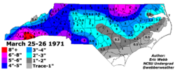
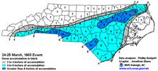
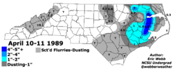
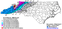
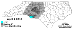
Agreed and you forgot to put 3/12/2017 up which was more widespread that 4/2019You’re not wrong in that it’s more rare, but there are exceptions. Certainly northern areas of the SE are more favored, though.
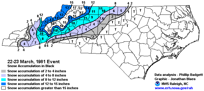
(Here’s a few examples of some nice very late storms…NC maps, sorry it’s all I have)
View attachment 133758
View attachment 133757
View attachment 133754
View attachment 133750
View attachment 133751
View attachment 133752
Now maybe because of climate change it’s just not possible to get these anymore. Maybe. But we saw accumulating snowfall in the region in lowland areas in April as recently as 2019, so I’m not so sure. I still say if we get a good pattern in mid-March it’s game on. It’s a tougher hill to climb than in mid-January, obviously, though. More has to go right.
View attachment 133759
It’s certainly not a good situation for the snowpack sticking around as the chances are we’ll be back in the. 50s/60s after any potential storm within a day or two. And timing matters more. Nighttime is best to not have to deal with daytime heating and the harsh sun angle, which is approaching the levels of late September by then. Certainly not going to see extended cold or anything like that. March storms are less than ideal because of all of this, but we have to take what we can get.It's hard to stay below freezing in mid March unless you are snowing like crazy or it's a once per 25 year airmass. Looking at the eps plumes 8 members have below 35 highs here over the coldest 4 day stretch so you are looking at about a 4% chance right now. That said there is a high % of the eps members that drive 850s below 0 and keep them there through the 4 day period. This time of year you have to understand that you are going to be fighting warmth in the 925 to sfc layer but having something supportive above 925 at least puts you in the game
Even with intense snowfall it’s hard to stay below freezing in mid to late March. The late March 1983 storm had 10.3” of daytime snow in CLT but the lowest temperature during that storm was 32… even when you look at the 1993 Superstorm, a lot of areas outside the mountains were in the low 30s during the heaviest snowfall.It's hard to stay below freezing in mid March unless you are snowing like crazy or it's a once per 25 year airmass. Looking at the eps plumes 8 members have below 35 highs here over the coldest 4 day stretch so you are looking at about a 4% chance right now. That said there is a high % of the eps members that drive 850s below 0 and keep them there through the 4 day period. This time of year you have to understand that you are going to be fighting warmth in the 925 to sfc layer but having something supportive above 925 at least puts you in the game
Even with intense snowfall it’s hard to stay below freezing in mid to late March. The late March 1983 storm had 10.3” of daytime snow in CLT but the lowest temperature during that storm was 32… even when you look at the 1993 Superstorm, a lot of areas outside the mountains were in the low 30s during the heaviest snowfall.
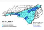
As someone who’s lived in the CLT area my whole life, that is very believable. The Carolina Crusher had a very similar sharp cutoff on the NW side as well. Southeastern Cabarrus County had 12-14” while northwest parts of the county 30 miles away had 2-3” with another 10-12 miles had basically nothingI was looking up the 1983 storm and came across this maps. Surely it can’t be right. Looks like it goes from 10” to nothing in like 30 or 40 miles. View attachment 133766
Sent from my iPhone using Tapatalk
It's a little concerning that the warmest anomalies are in the southeast. Despite all the cold, parts of the southeast still above normal ? I would definitely like this look if I lived in Chicago or Pittsburgh.
It's a little concerning that the warmest anomalies are in the southeast. Despite all the cold, parts of the southeast still above normal ? I would definitely like this look if I lived in Chicago or Pittsburgh.
You’re not wrong in that it’s more rare, but there are exceptions. Certainly northern areas of the SE are more favored, though.
(Here’s a few examples of some nice very late storms…NC maps, sorry it’s all I have)
View attachment 133758
View attachment 133757
View attachment 133754
View attachment 133750
View attachment 133751
View attachment 133752
Now maybe because of climate change it’s just not possible to get these anymore. Maybe. But we saw accumulating snowfall in the region in lowland areas in April as recently as 2019, so I’m not so sure. I still say if we get a good pattern in mid-March it’s game on. It’s a tougher hill to climb than in mid-January, obviously, though. More has to go right.
View attachment 133759

Same here. Woke up to 8” on the ground that year and it was gone by nightfall. I view March snows as bonus “enjoy the moment” events - you just aren’t going to get snowed-in barring a 100 year kind of thing. Even the ‘93 blizzard was basically a 1.5 day event around here.Even with intense snowfall it’s hard to stay below freezing in mid to late March. The late March 1983 storm had 10.3” of daytime snow in CLT but the lowest temperature during that storm was 32… even when you look at the 1993 Superstorm, a lot of areas outside the mountains were in the low 30s during the heaviest snowfall.
I stay normal to above average. I like it.It's a little concerning that the warmest anomalies are in the southeast. Despite all the cold, parts of the southeast still above normal ? I would definitely like this look if I lived in Chicago or Pittsburgh.
A few days later….Y'all have probably already seen this, or aren't surprised by it, but something to look at.....
View attachment 133767
This is for the whole month, which as warm as things start out, this seem pretty reasonableA few days later….
A few days later….
This is for the whole month, which as warm as things start out, this seem pretty reasonable
Week 1-2.5 of March will be warm. That last 7-10 day or so will be cool to cold depending on your location. Overall March will be above avg and April will come and tell the cold to get lost for good.Wow. They must be seeing something we are
missing in terms of indices? The GFS op clearly on to something.
Sent from my iPhone using Tapatalk
Yeah, but like I said, that map is for the entire month, the WPC is still going with below average likely for the 2nd and 3rd weeks of the month for at least the northern parts of the SE…. Even if that pans out which I think it will, the months as a whole could still be above average in the areas it’s showing.But we’ve known it was starting out warm for a long while.
Sent from my iPhone using Tapatalk
This is showing temperatures for the whole month of March while the first graphic shows from march 11-24th .. the first week of March is going to be very much above average so that fact that we even get back to average for the entire month shows how impressive our cold pattern will be. CheersA few days later….
Thank you!@Nomanslandva -
M means no data was recorded
T in summer is for hail
20-21 thru 22-23, 73-74 thru 75-76, and 54-55 thru 56-57 were all 3-year La Niña / Cool ENSO periods within multi-year -PDO regimes which tend to be detrimental to the Mid Atlantic for snowfall compared to normal (even moreso than in the southeast)
Oddly we’re still pretty ridgy at times
Sent from my iPhone using Tapatalk
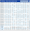
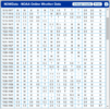
Love that you put some time into this, I’ve been wanting to do the same but it’s just too depressing.So, I am trying to figure out if this is the least snowiest winter in Roanoke. As you can see below, somehow, we had a trace each month Nov.-Feb. but I never even sniffed white ground although I did have one day with a slight glaze in trees in Dec. 19-20 was the worst year in the last 23 and this year would be worse with 0 measurable events so far. Ill also point out 06-09 was a bad 3 years. And last but not least for the first graphic look at the 7.3 for April 71. The Ts for June must be hail?
View attachment 133773
Going back a little farther, 90-91 was another crapper at 1.2 total and 2.3 75-76. 56-57 at was another bad year at 3.7. our airport data only goes back to 47, but there is some interesting area data from before then. 1918-1919 and 1919-1920 look like this year so far with nothing measurable. Then 1926-1930 look like they only had 3" total for the 4 winters and all of that was in the first year. In the earlier data I am assuming M=Missing but is missing because it was 0.
View attachment 133774
Bottom line, as bad as this feels now, it sure looks like it has happened before, and it also looks like sometimes it happens in blocks. Hopping this is the last year of this block of bad winters.
PS If I was more of a weenie and had more time I would try to figure out if those bad years were cold and dry or warm. maybe ENSO data too. But too little time.
Overrunning events can be that way sometimes. Sharp cutoff on the NW side.I was looking up the 1983 storm and came across this maps. Surely it can’t be right. Looks like it goes from 10” to nothing in like 30 or 40 miles. View attachment 133766
Sent from my iPhone using Tapatalk
The prior graphic with colder than average was for the later part of March, not the whole month. It’s apples to oranges.But we’ve known it was starting out warm for a long while.
Sent from my iPhone using Tapatalk
Haha, I get it!Love that you put some time into this, I’ve been wanting to do the same but it’s just too depressing.
Took tomorrow off so hopefully the warmer version.
