Hurricane Milton Discussion Number 19
NWS National Hurricane Center Miami FL AL142024
500 PM EDT Wed Oct 09 2024
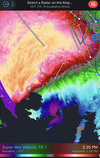
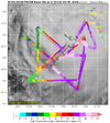
WSR-88D radar images from Tampa and Key West show that Milton is a
sheared hurricane, with the heaviest precipitation to the north of
the center, and the eye open on the south side. This structure was
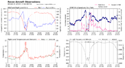
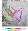
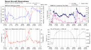
confirmed by a recent Air Force Reserve Hurricane Hunter mission,
where the eyewall was reported open to the southwest. The plane
reported that the pressure has risen during the past few hours, with
the latest center drop supporting a minimum pressure of 948 mb.
Based on this pressure, and the reduction of measured flight-level
winds, the intensity is estimated to be 105 kt. The highest
Doppler velocities from the Tampa radar have been between 100 and
105 kt.
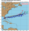
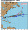
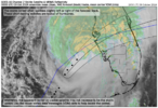
Milton's recent motion has been northeastward (035 degrees) at
about 15 kt. Track model guidance continues to insist that the
hurricane will slow down a bit and turn more to the right very
soon, taking the center near or just south of Tampa Bay later this
evening. Milton's center is then expected to cross central Florida
and turn east-northeastward as it emerges over the western Atlantic.
Milton is likely to be right near the threshold of a major
hurricane when it reaches the west-central coast of Florida this
evening. Milton has grown in size today, particularly in the extent
of 34- and 50-kt winds to the northwest of the center, and the
northern eyewall appears most severe at the moment due to
southwesterly shear. As a result, significant wind impacts are
likely to occur north of the center, as well as to the south,
regardless of the exact intensity at landfall. There will likely be
a noticeable gradient of surge heights to the north of the landfall
location, however, the risk of devastating storm surge still
exists across much of the west-central and southwest coast of
Florida given the size of the storm.
Earlier scatterometer data suggested that Milton is already
beginning to interact with a frontal boundary, and global model
guidance suggests that the cyclone will become extratropical in
about 36 hours over the western Atlantic. This is reflected in the
new NHC forecast.

