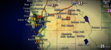
89 mph gust reported at the airport in St Pete https://www.weather.gov/wrh/timeseries?site=KSPG&hours=72
-
Hello, please take a minute to check out our awesome content, contributed by the wonderful members of our community. We hope you'll add your own thoughts and opinions by making a free account!
You are using an out of date browser. It may not display this or other websites correctly.
You should upgrade or use an alternative browser.
You should upgrade or use an alternative browser.
Tropical Major Hurricane Milton
- Thread starter SD
- Start date
lexxnchloe
Member
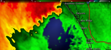
If you can see this radar it looks like an inner eye wall grew right over sarasota causing the high gusts
ChattaVOL
Member
Makeitsnow
Member
Not sure if its been mentioned but the rather tilted vortex is obvious if you look at keywest and miami radar. Pretty interesting to see the upper level portion of the eyewall coming ashore before the surface.
Shaggy
Member
Freddy mckinneys live stream is pretty solid
Not sure if its been mentioned but the rather tilted vortex is obvious if you look at keywest and miami radar. Pretty interesting to see the upper level portion of the eyewall coming ashore before the surface.
Yeah, it’s also highly visible on IR as well.
Live coming in on top of em
BULLETIN
Hurricane Milton Intermediate Advisory Number 19A
NWS National Hurricane Center Miami FL AL142024
800 PM EDT Wed Oct 09 2024
...MILTON CLOSE TO MAKING LANDFALL ALONG THE COAST OF WEST-CENTRAL
FLORIDA...
...LIFE-THREATENING STORM SURGE, DAMAGING WINDS, AND FLOODING RAINS
OCCURRING ACROSS PORTIONS OF CENTRAL AND SOUTHWESTERN FLORIDA...
SUMMARY OF 800 PM EDT...0000 UTC...INFORMATION
----------------------------------------------
LOCATION...27.2N 82.8W
ABOUT 20 MI...30 KM WSW OF SARASOTA FLORIDA
ABOUT 130 MI...205 KM SW OF ORLANDO FLORIDA
MAXIMUM SUSTAINED WINDS...120 MPH...195 KM/H
PRESENT MOVEMENT...ENE OR 60 DEGREES AT 15 MPH...24 KM/H
MINIMUM CENTRAL PRESSURE...954 MB...28.17 INCHES
Paging Larry......if Milton makes landfall around Sarasota....I must say, the EURO, AI and somewhat the UKMET (although it wast too far south fin the beginning for sure) overall*** did the best. HWRF and GFS were consistently too far NW with landfall.
Sarasota just tied their all time low pressure record at 962mb
This is called fading…


Sent from my iPhone using Tapatalk


Sent from my iPhone using Tapatalk
Paging Larry......if Milton makes landfall around Sarasota....I must say, the EURO, AI and somewhat the UKMET (although it wast too far south fin the beginning for sure) overall*** did the best. HWRF and GFS were consistently too far NW with landfall.
Thanks, Chris. How do you think the Icon has done?
honestly, I think it has done well enough to start paying more attention to it.Thanks, Chris. How do you think the Icon has done?
Mahomeless
Member
HWRF was the lowest verification throughout the eventPaging Larry......if Milton makes landfall around Sarasota....I must say, the EURO, AI and somewhat the UKMET (although it wast too far south fin the beginning for sure) overall*** did the best. HWRF and GFS were consistently too far NW with landfall.
lexxnchloe
Member
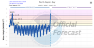
Sarasota airport. That east wind is pushing alot of water out. Its going to switch to wsw as high tide comes in and push alot of water in
| Humidity | 94% |
| Wind Speed | E 53 G 93 mph |
| Barometer | 28.42 in (962.4 mb) |
| Dewpoint | 75°F (24°C) |
| Visibility | 2.50 mi |
| Heat Index | 78°F (26°C) |
| Last update | 9 Oct 7:53 pm EDT |
This is a very dangerous situation. This is what should be on TV, or at least a point of emphasis. JMHO!
lexxnchloe
Member
Tornado damage
Brent
Member
NWS Doppler radar data indicate the eye of Hurricane Milton has
made landfall near Siesta Key in Sarasota County along the west
coast of Florida.
Also on the Atlantic coast
Multiple fatalities reported at Spanish Lakes Country Club in St. Lucie County due to a tornado, per the Sheriff office
made landfall near Siesta Key in Sarasota County along the west
coast of Florida.
Also on the Atlantic coast
Multiple fatalities reported at Spanish Lakes Country Club in St. Lucie County due to a tornado, per the Sheriff office
Landfall near Siesta Key as a cat 3.
NWS Doppler radar data indicate the eye of Hurricane Milton has
made landfall near Siesta Key in Sarasota County along the west
coast of Florida.
SUMMARY OF 830 PM EDT...0030 UTC...INFORMATION
-----------------------------------------------
LOCATION...27.3N 82.6W
ABOUT 5 MI...10 KM W OF SARASOTA FLORIDA
ABOUT 115 MI...185 KM SW OF ORLANDO FLORIDA
MAXIMUM SUSTAINED WINDS...120 MPH...205 KM/H
PRESENT MOVEMENT...ENE OR 60 DEGREES AT 15 MPH...24 KM/H
MINIMUM CENTRAL PRESSURE...954 MB...28.17 INCHES
Siesta key Cat 3 official
Watching some of these young relaxed hurricane hunters live in Bradenton beach makes me feel like I could do it.
This storm is a shell of its former self. Which is great news for Florida.
This storm is a shell of its former self. Which is great news for Florida.
Drizzle Snizzle
Member
I never see any female storm chasers.Watching some of these young relaxed hurricane hunters live in Bradenton beach makes me feel like I could do it.
This storm is a shell of its former self. Which is great news for Florida.
Shaggy
Member
I watch Connor croff and Freddy Mckinny more than reed timmer. Reed screams too much and these young chasers are really good tooWatching some of these young relaxed hurricane hunters live in Bradenton beach makes me feel like I could do it.
This storm is a shell of its former self. Which is great news for Florida.
That’s actually a great point. I think there may be a void to fill in that department. I know there are some tough women out there that love weather enough to do it.I never see any female storm chasers.
Drizzle Snizzle
Member
Connor and Freddy kinda look like brothers. They can’t be any older than 22.I watch Connor croff and Freddy Mckinny more than reed timmer. Reed screams too much and these young chasers are really good too
LickWx
Member
You could be the first!I never see any female storm chasers.
That kid looks exhausted on stream. Somebody get him a monster energy drinkI watch Connor croff and Freddy Mckinny more than reed timmer. Reed screams too much and these young chasers are really good too
- Joined
- Jan 23, 2021
- Messages
- 4,602
- Reaction score
- 15,197
- Location
- Lebanon Township, Durham County NC
Women have better survival instinctsI never see any female storm chasers.
Shaggy
Member
Did you watch them earlier when Beryl hit? Those dudes chased tornados all the way with the storm through Pennsylvania and New York for like 3 daysThat kid looks exhausted on stream. Somebody get him a monster energy drink
Stormsfury
Member
St Petersburg picked up 5.09" in the last hour, and over 12" in the last 7 hours.Radar estimated rainfall St. Pete 9”+ and still coming down very heavily. Flooding must be terrible.
Sctvman
Member
Brent
Member
Drizzle Snizzle
Member
I guess there’s still time to pass the 2011 outbreak ?
Mahomeless
Member
Sounds like the guy on IG who does the tornado siren…..ankle deep water at best….5 feet my ass


