• Hello, please take a minute to check out our awesome content, contributed by the wonderful members of our community. We hope you'll add your own thoughts and opinions by making a free account!

Tropical Major Hurricane Milton

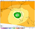
I'm not sure if it will make a difference, but 12z GFS has a noon Monday starting position of 982. This run may be trash....
But here it is anyway....North of Tampa for the 8th time I think.

gfs_mslp_wind_seus_12.png
 
i was going to post something a few hours ago like lol this might be sub 920 by lunch but deleted it because it was too hyperbolic. little did i know....

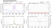
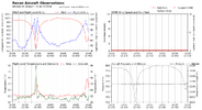
the recon plane just took on a 2k foot drop. one of those passes the crew will have stories about


1728316165295.png

this entire thing feels like a fever dream. this is the manifestation of one of those cheap "bad storm" documentaries the weather channel produced in the late 2000s as an innings killer when there was nothing interesting going on

i felt pretty sure this would weaken enough pre landfall to avoid the upper echelon emergency solutions but now i'm no so sure about that
 
...MILTON RAPIDLY INTENSIFIES INTO A CATEGORY 5 HURRICANE...

Data from an Air Force Reserve Hurricane Hunter aircraft indicate
that Milton has strengthened to a category 5 hurricane. The
maximum sustained winds are estimated to be 160 mph (250 km/h) with
higher gusts. Data from the aircraft also indicate that the
minimum pressure has fallen to 925 mb (27.31 inch
es).
 
I'm not sure if it will make a difference, but 12z GFS has a noon Monday starting position of 982. This run may be trash....
it does make a difference and every hurricane model we use (hwrf, hmon, hafs(s)) uses the gfs as the parent environment. if the gfs is this off the mark at initialization then this model suite may be cooked as the kids say
 
Hurricane Milton Tropical Cyclone Update
NWS National Hurricane Center Miami FL AL142024
1055 AM CDT Mon Oct 07 2024

...MILTON RAPIDLY INTENSIFIES INTO A CATEGORY 5 HURRICANE...

Data from an Air Force Reserve Hurricane Hunter aircraft indicate
that Milton has strengthened to a category 5 hurricane. The
maximum sustained winds are estimated to be 160 mph (250 km/h) with
higher gusts. Data from the aircraft also indicate that the
minimum pressure has fallen to 925 mb (27.31 inches).


SUMMARY OF 1055 AM CDT...1555 UTC...INFORMATION
-----------------------------------------------
LOCATION...21.7N 91.6W
ABOUT 125 MI...200 KM W OF PROGRESO MEXICO
ABOUT 735 MI...1175 KM SW OF TAMPA FLORIDA
MAXIMUM SUSTAINED WINDS...160 MPH...250 KM/H
PRESENT MOVEMENT...ESE OR 110 DEGREES AT 9 MPH...15 KM/H
MINIMUM CENTRAL PRESSURE...925 MB...27.31 INCHES
 
it does make a difference and every hurricane model we use (hwrf, hmon, hafs(s)) uses the gfs as the parent environment. if the gfs is this off the mark at initialization then this model suite may be cooked as the kids say
Heck, all the 12z models may be cooked.....flying blind.....but adding my public service announcement.
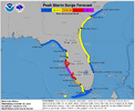
If you live on the west coast from cedar key to south of Tampa, do yourself a favor and evacuate !!!! Watch this one from as far away as you can get!!
 
i was going to post something a few hours ago like lol this might be sub 920 by lunch but deleted it because it was too hyperbolic. little did i know....

the recon plane just took on a 2k foot drop. one of those passes the crew will have stories about


this entire thing feels like a fever dream. this is the manifestation of one of those cheap "bad storm" documentaries the weather channel produced in the late 2000s as an innings killer when there was nothing interesting going on

i felt pretty sure this would weaken enough pre landfall to avoid the upper echelon emergency solutions but now i'm no so sure about that

Balls of steel, the lot of them. I couldnt in my wildest dreams.
 
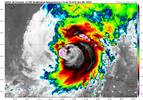
Oh my god. This is the stuff nightmares are made of for Tampa

aJpWvUY.png
 
I'm thinking of ships at sea closest to Milton. Is there a place online people go to check their weather instruments reporting?
 
Back
Top