Xtreme Weather
Member
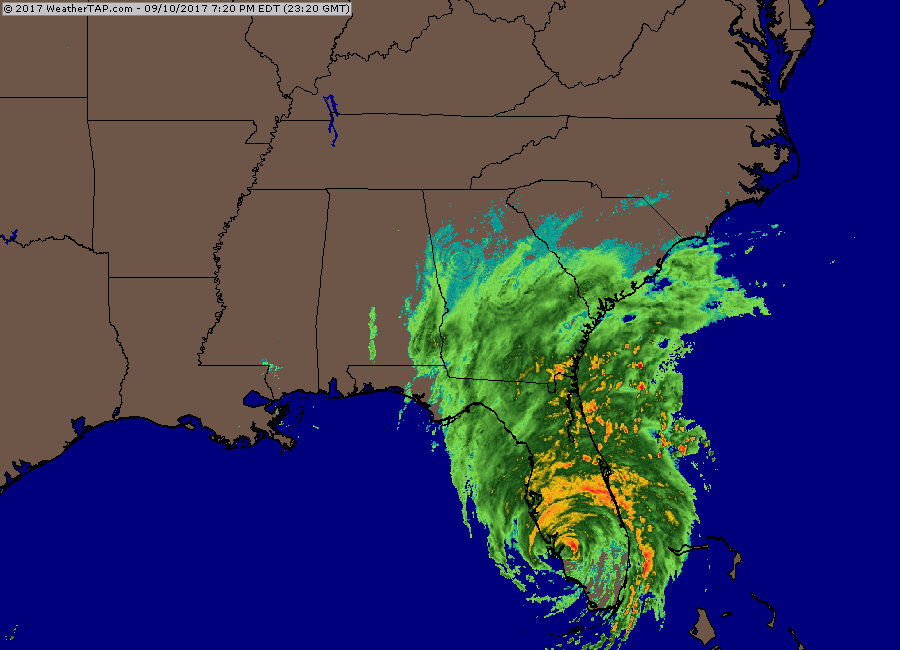
All the little meso's on ref.

This has been one of the most c amazing things I've seen. I know the science of it, but I don't remember ever seeing this before. Especially in so many locations.I do not recall ever seeing the widespread "draining" action with a tropical system.. Is this due to the overall size of the windfield?
I could see that happening as well just a delayed or further east start of turnI don't think the hard left turn happens near the state line. Think it's further north. It'll happen just think it's north
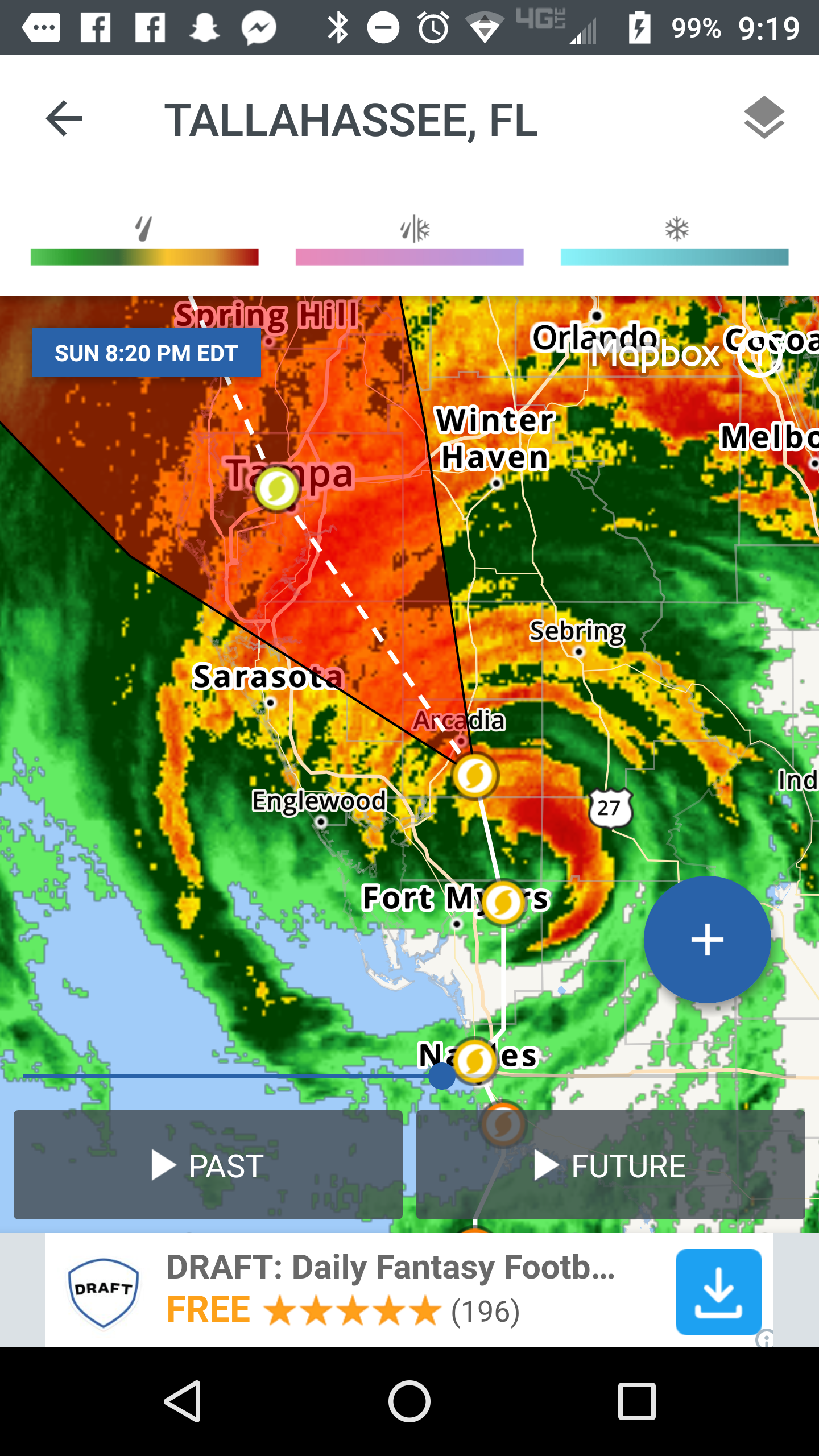
Breeze is down a little and rain starting to move in.Looks like Macon is starting to get rain. I'm interested in wow long until Chris reports a wind increase. T
other than the "down" ... dittoBreeze is down a little and rain starting to move in.
Was just looking at on RadarscopeAll the little meso's on ref.
Look at all these rotations geez

The whole thing means business ... said with power again ... for a few minutes, no doubt ...That band coming in near Melbourne really means business.


This things about to be over Orlando! But it's picking up speed, 14mph now, was 6-8mph most of the day!Fwiw
Sent from my SM-J320VPP using Tapatalk
Still a long way from Orlando...over 100 milesThis things about to be over Orlando! But it's picking up speed, 14mph now, was 6-8mph most of the day!

look how big she is right now, for goodness sakes ...Yes, its the NAM, but look at how big it thinks Irma would be when up in deep South GA on the IR sat.
No doubt she is huge already. The upper level clouds rolled in here around noon and have only become thicker.look how big she is right now, for goodness sakes ...

Nam looks a little east for the turnHmm. Tick east for sure on those early guidance models.
When you said "NAM...." I already tossed it.Nam looks a little east for the turn
Joke periodThe NAM isn't bad in short range, it's the NAM long range that is an absolute joke.
Looks like the 18z it's already on a NNW track by hour 12 in northern FloridaNam looks a little east for the turn
get it out of here any direction you please ...Looks like the 18z it's already on a NNW track by hour 12 in northern Florida
Sent from my SM-J320VPP using Tapatalk
Once Irma goes up into South GA, the NAM could very well be serious. Remember, it's a mesoscale model, so anything severe it is good with to some degree.Joke period
Even vertical up into space? LOL She will be out of your area tomorrow. However, I am sure it will be a long night ahead for you and many in Florida.get it out of here any direction you please ...
NAM has *from what I can tell* has some 100kt+ winds at 850mb pushing into south and mid ga then into NGALooks like the 18z it's already on a NNW track by hour 12 in northern Florida
Sent from my SM-J320VPP using Tapatalk
I know its the NAM but your right its a little later on the NW turn into GA. BTW, has some 100kt+ winds at 850mb when it gets in here.Hmm. Tick east for sure on those early guidance models.
Beam me up, Scotty ...Even vertical up into space? LOL She will be out of your area tomorrow. However, I am sure it will be a long night ahead for you and many in Florida.
I know its the NAM but your right its a little later on the NW turn into GA. BTW, has some 100kt+ winds at 850mb when it gets in here.
What I am trying to say if you couldn't figure it out is that once Irma reaches South GA, the NAM won't be as bad of a model. The NAM is a mesoscale model, so it is better with storms on land. Maybe not so much direction, but rather severe weather, squall band locations, etc. Not sure how you got " Irma isn't going into S GA" out of it.
The 12km and 3km are actually pretty nasty around here if this run is right...from what I can tell, about 45kt sustained winds and about 100kts at 850mb around here tomorrow.Yeah the NAM probably won't be as bad with Irma once it gets deeper into its domain and transitions to a cold core extratropical cyclone, with most of the convection and precipitation asymmetrical weighted to the west and north of the storm, because the model is largely incapable of resolving warm core processes ongoing in the inner cores of tropical cyclones, but tends to be a little better with mid-latitude cyclones.