Storm5
Member
06z gefs shifted back west

Sent from my SM-J320VPP using Tapatalk

Sent from my SM-J320VPP using Tapatalk
Just woke up and wow has it weakened. Is there any chance this will be a cat 3 or less at landfall???
its a cat 4Is it still a 5?
Sent from my iPhone using Tapatalk
Wow...... just wow. He doesn’t get it does he?Spann says no widespread power problems in Georgia
Sent from my SM-J320VPP using Tapatalk
Ya tell him to take hwy 41Just talked to a friend that was in Miami on vacation. He left Miami yesterday at lunchtime and he just called me from warner Robbins Ga. 75 dead stopped. I looked up directions to get him off interstate and some back roads.
And per NHC it is expected to stay a strong 4 borderline 5 up until landfall.its a cat 4
Wow...... just wow. He doesn’t get it does he?
Chris, he lives all the way up in Dalton. He going to take 96 over to 80 and then up 27 from ColumbusYa tell him to take hwy 41
I think a worse case scenario is the eyewall stays just offshore in the eastern Gulf headed due north. I know, I know...zero chance...lol
I guess they think Irma is done weakening.And per NHC it is expected to stay a strong 4 borderline 5 up until landfall
I agree. Irma is giving off this flasr sense of hope by weakening so fast over the last 12 to 24 hours, but in reality, the hurricane models had this happen, and Irma will gain or at least maintain intensity until landfall. It also still means a cat 4 minimum at landfall, or basically hurricane Andrew intensity hitting Miami and/or South Florida.To me one of the worse things about a hurricane becoming a monster Cat 5 with 185 mph winds as Irma did, aside from the damage obviously, is when it weakens to a still very dangerous and powerful Cat 4 or even a 3 there seems to be this collective sigh of relief. Almost an well it's weakened so it won't be that bad type of thinking..... this is dangerous thinking.
I think that the weakening its gone through the last 24 hrs, from 185 to 150 is going to make a lot of people decide to stay.I agree. Irma is giving off this flasr sense of hope by weakening so fast over the last 12 to 24 hours, but in reality, the hurricane models had this happen, and Irma will gain or at least maintain intensity until landfall. It also still means a cat 4 minimum at landfall, or basically hurricane Andrew intensity hitting Miami and/or South Florida.

I agree. Irma is giving off this flasr sense of hope by weakening so fast over the last 12 to 24 hours, but in reality, the hurricane models had this happen, and Irma will gain or at least maintain intensity until landfall. It also still means a cat 4 minimum at landfall, or basically hurricane Andrew intensity hitting Miami and/or South Florida.
It was interesting seeing the ensembles tick west again but I still believe we see an east trend . Nothing major like the NAM showed last night . But every little shift has big impacts for Georgia and SC and parts of NCSure looks like Irma is approaching the western edge of the WAR.... also when you look at wv loop there is a lot going on at H5 to still work out, that ec trough and those 2 very noticeable sw's diving across Nebraska and the Dakota's. Still a long way to go with this one I'm afraid
http://www.ssd.noaa.gov/goes/east/eaus/h5-loop-wv.html
Yeah I'm not sure of anything anymore Lol.... when you look at the wind map and see that massive trough and WAR getting beat back you wonder why it's still heading west. I saw one of your post the other night that asked a very good question, why isn't it gonna feel that weakness? (not that I want it, I rather the trough had picked it up and shot out to sea) I guess the trough is lifting and it's missing it but the weakness is still there so I'm about 90% in on the Euro but we know how these go sometimesIt was interesting seeing the ensembles tick west again but I still believe we see an east trend . Nothing major like the NAM showed last night . But every little shift has big impacts for Georgia and SC and parts of NC
Sent from my SM-J320VPP using Tapatalk


Yeah I'm not sure of anything anymore Lol.... when you look at the wind map and see that massive trough and WAR getting beat back you wonder why it's still heading west. I saw one of your post the other night that asked a very good question, why isn't it gonna feel that weakness? (not that I want it, I rather the trough had picked it up and shot out to sea) I guess the trough is lifting and it's missing it but the weakness is still there so I'm about 90% in on the Euro but we know how these go sometimes
https://earth.nullschool.net/#curre.../winkel3=270.81,35.76,1383/loc=-82.813,27.896
Still never got a response lol. Thats a huge weakness, and I still don't get with such a powerful storm why we don't end up with a more northerly track sooner. Then Larry said most storms in the past located at a similar location as Irma almost never turn to the north .Yeah I'm not sure of anything anymore Lol.... when you look at the wind map and see that massive trough and WAR getting beat back you wonder why it's still heading west. I saw one of your post the other night that asked a very good question, why isn't it gonna feel that weakness? (not that I want it, I rather the trough had picked it up and shot out to sea) I guess the trough is lifting and it's missing it but the weakness is still there so I'm about 90% in on the Euro but we know how these go sometimes
https://earth.nullschool.net/#curre.../winkel3=270.81,35.76,1383/loc=-82.813,27.896
What makes you think this?It was interesting seeing the ensembles tick west again but I still believe we see an east trend . Nothing major like the NAM showed last night . But every little shift has big impacts for Georgia and SC and parts of NC
Sent from my SM-J320VPP using Tapatalk
As met pointed out if Irma does not take on a more west track over the next few hours it's going to stay a little North of the NHC track. Add to the fact the models have trended ever so slightly stronger with the trough I just think we see a small east correction, nothing major . Ive been wrong before plenty of times.What makes you think this?

That would be good, but maybe I’m stubborn. LOL, I am. LOL I think it’ll be pretty close to a minimal hurricanes at that point. yes, it’s going to weekend. But pressures are very low, even well inland. And the models have pretty high sustained winds at certainly higher gustsLooks like the NHC has Irma as a 45 mph tropical storm around Macon Georgia . That would be really good news for out Georgia friends. The weaker the better
Sent from my SM-J320VPP using Tapatalk
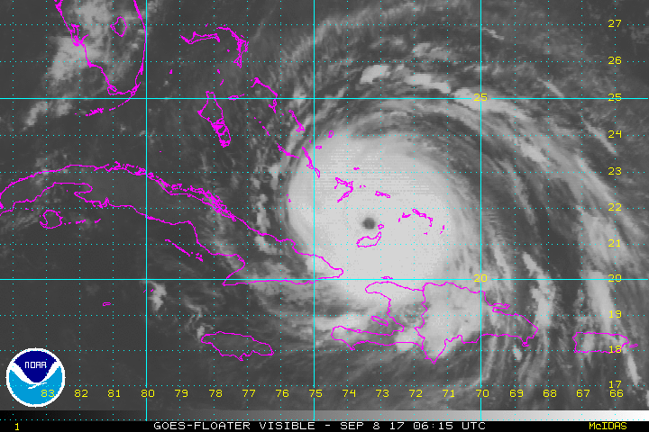
The eye seems to be shrinking too.You can see her grow in size
