Webberweather53
Meteorologist
As Forsythsnow mentioned, a NOAA aircraft is en route from Bermuda now to sample the environment around Florence, hopefully we'll know more by the 0z runs tonight.

Basically, you could even stretch as far south as Savannah.Trying to catch up from the runs overnight. It looks like most of the models show Flo hitting between Charleston and somewhere in NC. Does that sound right?
So the longer it stays weaker and unorganized, the more likely the southern solutions will be correct?Florence is beginning to mix and ingest dry air to the south & east of the center, it's going to be a while before we see this storm go nuts, likely won't be today, but later on Sunday or Monday different story.
View attachment 5978
So the longer it stays weaker and unorganized, the more likely the southern solutions will be correct?
So the longer it stays weaker and unorganized, the more likely the southern solutions will be correct?
I wouldn't be so eager here. While Mimmic looks nice for the moment, there's a noteworthy push of dry air that's wrapped all the way to the eastern side of the circulation and will likely penetrate whatever core is trying to build here and cloud tops have warmed appreciably, this has a long ways to go before we see any very substantial strengthening. Even as the LLC & MLC become vertically stacked, it takes time, usually on the order of 36 hours (or more) for non-linear convective feedbacks and PV redistribution to begin in earnest and allow the core to warm again.
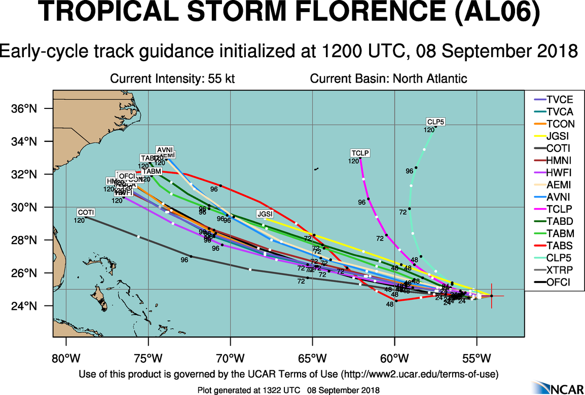
View attachment 5977


Yes it doesOn infrared, Flo looks like crap!
With what we are looking at at this lead time I think a NE trend is unlikely. Theres just too much of a blocking ridge to the north to believe a NE trend is likely. To me a shift a little more SW would be the more likely outcome. But again we are still 5-6 days away things will change.Is anybody anticipating to model nw trend to start like I am? I still feel like the models are overreacting now and we will start to see the track move up the coast as the ridge will not be as strong as projected. Doesn’t this normally happen with recurve projected storms?
Starting to feel a little better about mby, seeing it stay weaker a little longer and the eps and mogreps with clustering south. Still too early and I'm no way wishing this for our friends to our south.Basically, you could even stretch as far south as Savannah.
Sent from my SM-G955U using Tapatalk
Starting to feel a little better about mby, seeing it stay weaker a little longer and the eps and mogreps with clustering south. Still too early and I'm no way wishing this for our friends to our south.
Sent from my SM-G920V using Tapatalk

Unfortunately, it's a very different ballgame down here in Charlotte atm, a track into South Carolina or even Savannah would bring the core of Florence into the southwestern piedmont.
Slow clapLooks like some of the 12z models are trying to go for a Florida Georgia Line landfall.
(I snagged this from WU).
View attachment 5986
Unfortunately, it's a very different ballgame down here in Charlotte atm, a track into South Carolina or even Savannah would bring the core of Florence into the southwestern piedmont.
Very, very Hugo like! I know different angle and yadda, yadda, but CAE and CLT and in between, got wrecked after CHS was decimated!Unfortunately, it's a very different ballgame down here in Charlotte atm, a track into South Carolina or even Savannah would bring the core of Florence into the southwestern piedmont.
Yeah I think the far NE solution toward your area is running out of steam. I think the greatest area of concern is really the central SC coast from Charleston to myrtle.Starting to feel a little better about mby, seeing it stay weaker a little longer and the eps and mogreps with clustering south. Still too early and I'm no way wishing this for our friends to our south.
Sent from my SM-G920V using Tapatalk
Yep. That’s my concern at this time. I further south track around the Savannah area could be devastating for this area.
Sent from my iPhone using Tapatalk
I snagged some to lolLooks like some of the 12z models are trying to go for a Florida Georgia Line landfall.
(I snagged this from WU).
View attachment 5986
With what we are looking at at this lead time I think a NE trend is unlikely. Theres just too much of a blocking ridge to the north to believe a NE trend is likely. To me a shift a little more SW would be the more likely outcome. But again we are still 5-6 days away things will change.
Sent from my SM-G955U using Tapatalk
i agree I think the NE movement would be the least possible moves at this point.Yeah I think the far NE solution toward your area is running out of steam. I think the greatest area of concern is really the central SC coast from Charleston to myrtle.
Sent from my SM-G955U using Tapatalk
Unfortunately it could be true unless this thing goes through central Florida on the off chance it also has on going out to sea. Only possibility of a miss to members would be just south of Brunswick GA. Unfortunately that would bring worse than irma winds up here but at least it won't be as bad as a Savannah hit or a Myrtle Beach hit which would affect a large portion of the board. Very few easy ways out of this one.Yeah that's the last thing I want to see, but I also don't want this to go so far south that it puts Larry and Phil in serious trouble, the very harsh reality is somebody on this forum is liable to get absolutely crushed by this storm & their lives will change forever.
Yeah that's the last thing I want to see, but I also don't want this to go so far south that it puts Larry and Phil in serious trouble, the very harsh reality is somebody on this forum is liable to get absolutely crushed by this storm & their lives will change forever.
")
Myrtle needs a fresh start! J/k, mostly!? The far S solutions, CHS and such, still put a lot into the right front quadrant, or tornado side, depending on eventual size!Yeah I think the far NE solution toward your area is running out of steam. I think the greatest area of concern is really the central SC coast from Charleston to myrtle.
Sent from my SM-G955U using Tapatalk
Myrtle needs a fresh start! J/k, mostly!? The far S solutions, CHS and such, still put a lot into the right front quadrant, or tornado side, depending on eventual size!
Not to mention this would be an unusual track for most of nc. Not very often we see a hurricane with a westward component to its track moving through SC. Would set up a good part of the southern half of the state for a long period of high wind gusts.Good point, the tornado threat will extend well outside the core of the storm to the right of its track and would most likely be moderate or high overall given Florence's projected intensity being able to provide a ton of low-level shear, at least more than we're "typically accustomed" to w/ a weaker category 1 or 2 hurricane that occur more frequently around here.
Not to mention the immense rain totals that would pile up for the southern and eastern escarpment due to enhancement with that track.Not to mention this would be an unusual track for most of nc. Not very often we see a hurricane with a westward component to its track moving through SC. Would set up a good part of the southern half of the state for a long period of high wind gusts.
Sent from my SM-G955U using Tapatalk
No kidding. Took the euro 3 days to get from the SC coast to SW Va that's a lot of deep SE to E flow for the mountainsNot to mention the immense rain totals that would pile up for the southern and eastern escarpment due to enhancement with that track.
Recon on the way now and will be there soon . I guess waiting till Monday went out the window lol
Sent from my iPhone using Tapatalk
That would not be ideal. One mountain that is traveled pretty heavily here locally is down to one lane in each direction as one of the lanes is being eroded away on the mountain side from all the rain this spring and summer.No kidding. Took the euro 3 days to get from the SC coast to SW Va that's a lot of deep SE to E flow for the mountains
Sent from my SM-G955U using Tapatalk
That's actually just a NOAA research aircraft (at least I thought?). The NHC plan of the day still shows won't get the big C-130s in there til Monday morning. Regardless, any data should help

You are right it’s a NOAA plane
Sent from my iPhone using Tapatalk