BHS1975
Member
WHAT IS THE BEST SITE(S) FOR IR SAT IMAGE
https://www.tropicaltidbits.com
Sent from my iPhone using Tapatalk
WHAT IS THE BEST SITE(S) FOR IR SAT IMAGE
Maybe it's an effect of what you're saying, but it seems like the convection is slightly being tugged in a WSW motion, but it's late my eyes could be messing with me right now.

Here are a couple of good ones:WHAT IS THE BEST SITE(S) FOR IR SAT IMAGE
Yep. Here is image at 144 947MB lowgeez the UKMET Is almost in Georgia
0000UTC 14.09.2018 144 31.4N 79.2W 939 87
would be between Savannah and Charleston

Maybe it's an effect of what you're saying, but it seems like the convection is slightly being tugged in a WSW motion, but it's late my eyes could be messing with me right now.
Grief. That would do some serious damage to Ocracoke island...and many more
Yes, the LLC was on the south side of the convection and with shear subsiding it appears the convection is trying to expand SW over the LLC. Tough to tell for sure since we don’t have satellite but latest shear analysis and current IR suggests this may be the case.

Say hello to shortwave IR or night visible. Florence is still a good way off from major intensification.


Florence is really not expected to intensify much over the next day or two. This westerly shear, even tomorrow, will be near 20 KTS and even after the MLC and LLC become vertically stacked it doesn't immediately begin intensifying. It takes time for latent heating release to trigger changes in PV distribution, often a day or two after Florence has become better organized in general, for MSLP to begin lowering in a remarkable fashion and for the storm to have a nearly complete inner core s.t. more significant intensification can occur as the buoyancy reservoir (the eye) can close off, increasing the baroclinicity between the eye & the eyewall s.t. that the winds & secondary circulation become stronger. It seems that the earliest this might happen is late Sunday or even Monday.
.gif")

.png") Euro again has a Hugo-ish track, just east of Charleston at 144
Euro again has a Hugo-ish track, just east of Charleston at 144.png")

What are the wind speeds when it makes landfall? (EURO)
.png")
.png")
Borderline Cat4. Prob downgraded to a Cat3 once half of the eyewall crosses over the coast. My dad told me stories of Hugo. Said they were working in Santee which is well inland. They left for a few days until Hugo pushed through and when they came back he said it was unrecognizable. He couldn’t believe it. These things can do serious damage WELL inland


.png")
Pic please0z EPS is more of the same, anywhere between Daytona Beach, FL & Cape Hatteras, NC could be under the gun.
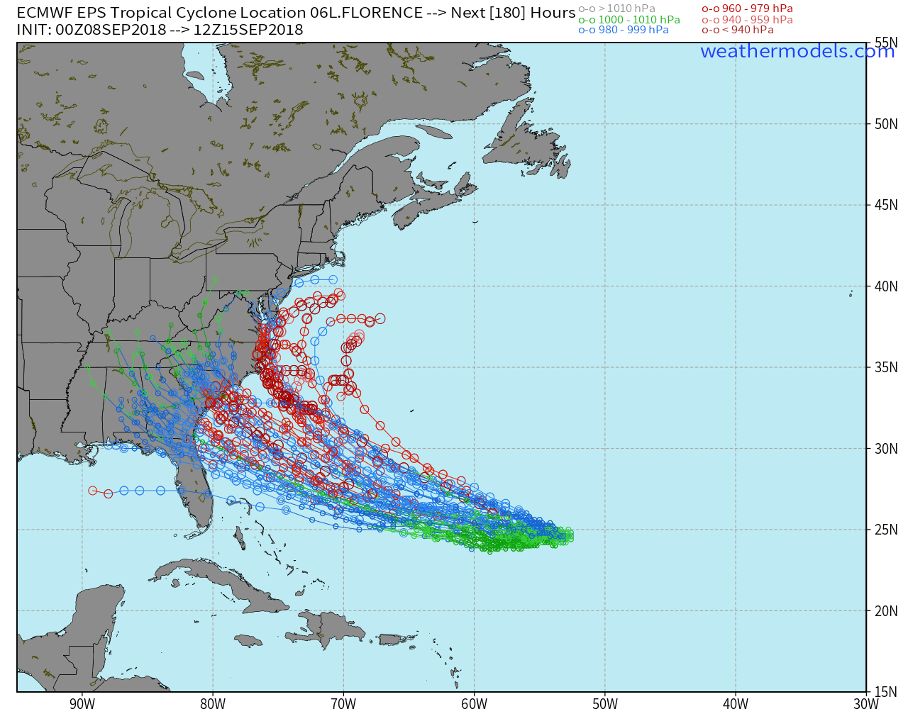
There's more clusters Fl/GA0z EPS is more of the same, anywhere between Daytona Beach, FL & Cape Hatteras, NC could be under the gun.
You can easily see the early biurification of EPS members with stronger members early on gaining more latitude later and affecting mainly the mid-Atlantic or eastern NC. The members that take more time for Florence to develop constitute the overwhelming majority of the southern cluster that hits north FL, GA, and portions of south-central SC. We'll have to give this a few more days to see which cluster is more likely to verify although we've been progressively trending towards the southern cluster
Morning all
Is this a night time landfall or day?
Thanks


