and a mighty big sw tug at that
-
Hello, please take a minute to check out our awesome content, contributed by the wonderful members of our community. We hope you'll add your own thoughts and opinions by making a free account!
You are using an out of date browser. It may not display this or other websites correctly.
You should upgrade or use an alternative browser.
You should upgrade or use an alternative browser.
Tropical Major Hurricane Florence
- Thread starter ForsythSnow
- Start date
Webberweather53
Meteorologist
5am NHC advisory shifted the long term track of Florence just a little to the left of the previous advisory and intensity at the end of the period increased to 125 KT (145 mph). Yikes.
Webberweather53
Meteorologist
I can't recall too many instances where the NHC has gone this crazy w/ an intensity forecast in the medium range. Yikes.
INIT 08/0900Z 24.5N 54.2W 55 KT 65 MPH
12H 08/1800Z 24.6N 55.0W 60 KT 70 MPH
24H 09/0600Z 24.6N 56.0W 65 KT 75 MPH
36H 09/1800Z 24.6N 57.2W 75 KT 85 MPH
48H 10/0600Z 24.9N 59.0W 90 KT 105 MPH
72H 11/0600Z 26.0N 64.0W 105 KT 120 MPH
96H 12/0600Z 28.0N 70.2W 120 KT 140 MPH
120H 13/0600Z 30.9N 75.8W 125 KT 145 MPH
Webberweather53
Meteorologist
Florence has been tracking just south of the several most recent NHC forecasts, largely due to the fact that the storm weakened considerably to a TS and remained weaker longer than some models like the GFS for example, were anticipating. The next 72 hours are going to be crucial in determining precisely where Florence makes a direct hit on the SE US coast.

LovingGulfLows
Member
- Joined
- Jan 5, 2017
- Messages
- 1,499
- Reaction score
- 4,100
I'll be in Chicago roughly around the time this strikes the SE. Worried for my brother though while I'm gone as there could be a period without power if the center is anywhere close to the Atlanta area. I guess we'll have to closely see how this develops. Irma did some damage here and it was barely a tropical storm.
Alex
Member
Webber, can you recall the last time or two that they have? If not, would you know where I might be able to dig up this information?
Sent from my Pixel 2 XL using Tapatalk
I can't recall too many instances where the NHC has gone this crazy w/ an intensity forecast in the medium range. Yikes.
INIT 08/0900Z 24.5N 54.2W 55 KT 65 MPH
12H 08/1800Z 24.6N 55.0W 60 KT 70 MPH
24H 09/0600Z 24.6N 56.0W 65 KT 75 MPH
36H 09/1800Z 24.6N 57.2W 75 KT 85 MPH
48H 10/0600Z 24.9N 59.0W 90 KT 105 MPH
72H 11/0600Z 26.0N 64.0W 105 KT 120 MPH
96H 12/0600Z 28.0N 70.2W 120 KT 140 MPH
120H 13/0600Z 30.9N 75.8W 125 KT 145 MPH
Sent from my Pixel 2 XL using Tapatalk
snowlover91
Member
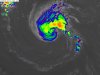
Look how quickly she is organizing her core too.5am NHC advisory shifted the long term track of Florence just a little to the left of the previous advisory and intensity at the end of the period increased to 125 KT (145 mph). Yikes.
http://tropic.ssec.wisc.edu/real-time/mimtc/2018_06L/web/displayGifsBy12hr_09.html
packfan98
Moderator
6z gfs is trying its best to have Florence miss the SE. it’s NE of the 0z run due to steady intensification over the next 36 hours. I would think that we should know by tomorrow night if there’s any room for a recurve. I put that at a less than 10% chance at the moment.
packfan98
Moderator
Gfs is nuts. It stalls off Hatteras for days as the pressure drops to 904mb. Highly doubtful!
packfan98
Moderator

Gfs is nuts. It stalls off Hatteras for days as the pressure drops to 904mb. Highly doubtful!
i wouldnt write it off as nuts yet
I would agree, not 0 chance but that window is closing fast, now let's see how quickly or slowly it intensifies since this really is a major factor in exactly who feels the most impact..... next 48 hours critical to determining that6z gfs is trying its best to have Florence miss the SE. it’s NE of the 0z run due to steady intensification over the next 36 hours. I would think that we should know by tomorrow night if there’s any room for a recurve. I put that at a less than 10% chance at the moment.
BHS1975
Member
Fv5 coming in a bit south of the gfs. Looks like it’s keying in on that weakness over the se like the gfs to turn her north.
Sent from my iPhone using Tapatalk
Sent from my iPhone using Tapatalk
packfan98
Moderator
Yeah, I asked Allan Huffman about the run.i wouldnt write it off as nuts yet
Really nothing to add to track thinking as the Eps really tells the story, as you can see the sooner it intensifies the further north the tracks and vice versa...

Yeah, I asked Allan Huffman about the run.
Yeah probably unlikely but look at the Eps, it has some members doing a loop off the coast..... longs way to go with Florence yet
The GFS may be some what of an outlier at the moment but little concerning for us to see it coming back north... the Fv3 is looking extremely problematicFv5 coming in a bit south of the gfs. Looks like it’s keying in on that weakness over the se like the gfs to turn her north.
Sent from my iPhone using Tapatalk
Webberweather53
Meteorologist
Look how quickly she is organizing her core too.
http://tropic.ssec.wisc.edu/real-time/mimtc/2018_06L/web/displayGifsBy12hr_09.html
I wouldn't be so eager here. While Mimmic looks nice for the moment, there's a noteworthy push of dry air that's wrapped all the way to the eastern side of the circulation and will likely penetrate whatever core is trying to build here and cloud tops have warmed appreciably, this has a long ways to go before we see any very substantial strengthening. Even as the LLC & MLC become vertically stacked, it takes time, usually on the order of 36 hours (or more) for non-linear convective feedbacks and PV redistribution to begin in earnest and allow the core to warm again.

Really nothing to add to track thinking as the Eps really tells the story, as you can see the sooner it intensifies the further north the tracks and vice versa...
Looks like based on those members if it will take the NC or loop route it has to start the NW turn right now. Otherwise if it holds it's West track it's a bullet for the GA/SC border area. Makes sense and should be fun to watch.
Webberweather53
Meteorologist
Florence is beginning to mix and ingest dry air to the south & east of the center, it's going to be a while before we see this storm go nuts, likely won't be today, but later on Sunday or Monday different story.

For the most part yeah I see that but if you really look at all the members there are still a handful in that southern cluster that strengthen before 70W and get pretty far north.... anyway but yeah "fun" to watch no doubtLooks like based on those members if it will take the NC or loop route it has to start the NW turn right now. Otherwise if it holds it's West track it's a bullet for the GA/SC border area. Makes sense and should be fun to watch.
Webberweather53
Meteorologist
The 6z HWRF's evolution of the general intensity & its trends going forward w/ Florence seem fairly reasonable, in line with what I'm (& the NHC) are thinking, Florence probably won't really take off until Sunday night or Monday. Florence completing its eyewall will be the key initial step in kickstarting a significant bout of intensification, and this is bound to take something in the ballpark of 30-36 hours given the dry air its about to ingest, current organization, and how high the shear still is atm (although it's falling as we speak).

whatalife
Moderator
Really nothing to add to track thinking as the Eps really tells the story, as you can see the sooner it intensifies the further north the tracks and vice versa...
I think you have the EPS from 12z yesterday. Here is the 00z EPS today....

Sent from my iPhone using Tapatalk
Webberweather53
Meteorologist
6z HWRF ticked ever so slightly SW of its 0z run, not a huge surprise because it has a poleward bias just like its parent model, the GFS.
That is a nasty slug of dry stable air wrapping into Florence. You can easily see it on IR to the west and SW of Flo. As Webb stated, it will take a while to get that out and with the shear dying to help sustain what convection there is, Flo may look really bad over the next 24-36hrs. And while unlikely, there is a lot of those ensembles that never strengthen it much and this could be why.
Attachments
.I think you have the EPS from 12z yesterday. Here is the 00z EPS today....
Sent from my iPhone using Tapatalk

Sent from my SM-G920V using Tapatalk
whatalife
Moderator
.
Sent from my SM-G920V using Tapatalk

Sent from my iPhone using Tapatalk
.
Sent from my SM-G920V using Tapatalk
I don't blame you, I blame the management.
Webberweather53
Meteorologist
Florence's WSW motion over the last several hours is putting outside or on the outside edge of the GEFS envelope, expect a westward shift in this suite in forthcoming runs. In a situation like this where there's a rebuilding ridge overhead, it's often a good idea to use the GEFS/GFS models to denote the eastern edge of the envelope of legitimate solutions because this model will almost always (& already has) trend(ed) SW. Given that this eastern edge is already near or over Hatteras, certainly leaves a sinking feeling in the pit of my stomach wrt the chances Florence hits the SE US coast.

For the sake of prosperity of mentioning every model guidance out there, 6z NAVGEM looks to be NC bound at the end of it's run at hr. 144.

Florence's WSW motion over the last several hours is putting outside or on the outside edge of the GEFS envelope, expect a westward shift in this suite in forthcoming runs. In a situation like this where there's a rebuilding ridge overhead, it's often a good idea to use the GEFS/GFS models to denote the eastern edge of the envelope of legitimate solutions because this model will almost always (& already has) trend(ed) SW. Given that this eastern edge is already near or over Hatteras, certainly leaves a sinking feeling in the pit of my stomach wrt the chances Florence hits the SE US coast.
I noticed between the 11pm and 5am advisories Florence has lost some latitude (24.9N to 24.5N).
Here was last night's Ukmet ensembles.

Snowflowxxl
Member
Wow that’s a lot of Florida hitsHere was last night's Ukmet ensembles.
View attachment 5982
ForsythSnow
Moderator
First plane is on it's way in now. Let's see what is and isn't about this storm.
6z FV3-GFS - It was a SC landfall on the 00z run last night.
EDIT: It stalls/meanders over Eastern NC for at least the next 36hrs after this timeframe.

EDIT: It stalls/meanders over Eastern NC for at least the next 36hrs after this timeframe.
Storm5
Member
I don't blame you, I blame the management.
You sound like some of the people I work with
Sent from my iPhone using Tapatalk
B
Brick Tamland
Guest
Trying to catch up from the runs overnight. It looks like most of the models show Flo hitting between Charleston and somewhere in NC. Does that sound right?
TWC’s cone has it off the Carolinas coast at 145 mph winds, early Thursday morning!
Here goes that loop de loop idea....

Yes, the forward speed has a lot to do with that! I mean Hugo made landfall at 135 mph , I believe. CLT and Gastonia has gusts to around 90 mph +Borderline Cat4. Prob downgraded to a Cat3 once half of the eyewall crosses over the coast. My dad told me stories of Hugo. Said they were working in Santee which is well inland. They left for a few days until Hugo pushed through and when they came back he said it was unrecognizable. He couldn’t believe it. These things can do serious damage WELL inland