Kylo
Member
I think models would re adjust to a track out to sea. As I dont see this storm becoming weak again and missing the weakness.I remember last year with Irma at this range where it was a showing a NC/SC hit and UK was furtherest southwest. It was being discounted because the maps below were showing the OBS north of the modeled track. Irma ended up tracking within the cone below for the most part. If I had any money I would bet on a recurve because this is going to take a really strong ridge to keep this climbing poleward.
438
WTNT31 KNHC 051439
TCPAT1
BULLETIN
Hurricane Florence Advisory Number 25
NWS National Hurricane Center Miami FL AL062018
1100 AM AST Wed Sep 05 2018
...FLORENCE FLOURISHING IN THE FACE OF SOUTHWESTERLY SHEAR...
SUMMARY OF 1100 AM AST...1500 UTC...INFORMATION
-----------------------------------------------
LOCATION...22.0N 45.7W
ABOUT 1160 MI...1865 KM ENE OF THE NORTHERN LEEWARD ISLANDS
ABOUT 1370 MI...2205 KM ESE OF BERMUDA
MAXIMUM SUSTAINED WINDS...125 MPH...205 KM/H
PRESENT MOVEMENT...NW OR 305 DEGREES AT 13 MPH...20 KM/H
MINIMUM CENTRAL PRESSURE...957 MB...28.26 INCHES
WATCHES AND WARNINGS
--------------------
There are no coastal watches or warnings in effect.
DISCUSSION AND OUTLOOK
----------------------
At 1100 AM AST (1500 UTC), the eye of Hurricane Florence was
located near latitude 22.0 North, longitude 45.7 West. Florence is
moving toward the northwest near 13 mph (20 km/h), and this general
motion is expected to continue through tonight. A turn toward the
west-northwest with a decrease in forward speed is forecast on
Thursday, followed by a turn back toward the northwest early next
week.
Satellite images indicate that maximum sustained winds have
increased to near 125 mph (205 km/h) with higher gusts. Florence is
a category 3 hurricane on the Saffir-Simpson Hurricane Wind Scale.
Some weakening is possible during the next few days, but Florence is
expected to remain a strong hurricane through early next week.
Hurricane-force winds extend outward up to 15 miles (30 km) from the
center, and tropical-storm-force winds extend outward up to 90 miles
(150 km).
The estimated minimum central pressure is 957 mb (28.26 inches).
HAZARDS AFFECTING LAND
----------------------
None.
NEXT ADVISORY
-------------
Next complete advisory at 500 PM AST.
$$
Forecaster Berg/Rhome
150
WTNT41 KNHC 051440
TCDAT1
Hurricane Florence Discussion Number 25
NWS National Hurricane Center Miami FL AL062018
1100 AM AST Wed Sep 05 2018
Remarkably, Florence has continued to strengthen. The hurricane
has a compact central dense overcast with cold cloud tops completely
encircling a clear, well-defined eye. With the improved structure,
subjective Dvorak estimates have increased to T5.5/102 kt from TAFB
and T6.0/115 kt from SAB, while the latest objective UW-CIMSS ADT
estimate is T5.8/110 kt. The initial intensity is therefore set at
110 kt as a blend of these numbers, with Florence having become a
major hurricane earlier this morning.
Given the estimated maximum winds, Florence has been rapidly
intensifying since yesterday, an event that was not foreseen by any
intensity models, nor forecasters. Diagnostics from the SHIPS
model and UW-CIMSS shear analyses have been consistently showing
southwesterly shear of 20-25 kt in the vicinity of Florence, but it
is possible that those schemes are averaging over a larger area
than might be reasonable given the hurricane's small size. Florence
has apparently been able to find a small pocket of relatively low
shear, and with waters becoming progressively warmer, the hurricane
has strengthened significantly more than anticipated. This makes
the intensity forecast incredibly uncertain. SHIPS actually shows
the shear increasing over the next 24 hours, but global model
fields suggest that the hurricane may still be able to continue
within the protected pocket of lower shear for the next several
days. As a result, the NHC official forecast keeps Florence's
intensity well above the available guidance, which all show the
hurricane weakening over the next day or two. The new NHC
prediction follows this trend and also shows some weakening, but
this is a low-confidence forecast. Either way, Florence is
expected to remain a hurricane throughout the 5-day period.
The track forecast also has its challenges. The initial motion
estimate is northwestward, or 305/11 kt. It now appears that
stronger upper-level ridging may take shape to the north of
Florence over the next few days, forcing the hurricane to turn back
toward the west-northwest from 36-72 hours. After 72 hours, a
break in the ridge should allow Florence to turn back toward the
northwest, but the bulk of the track models have trended westward
since yesterday. In light of these trends, the NHC official track
forecast has been shifted westward on days 4 and 5, but not quite
as far as the various model consensus aids. It is worth stressing
that there is still a significant amount of spread among the GFS
and ECMWF ensemble members by the end of the forecast period, and
just like the intensity forecast, the track forecast is of low
confidence.
FORECAST POSITIONS AND MAX WINDS
INIT 05/1500Z 22.0N 45.7W 110 KT 125 MPH
12H 06/0000Z 22.7N 47.2W 110 KT 125 MPH
24H 06/1200Z 23.8N 49.0W 100 KT 115 MPH
36H 07/0000Z 24.7N 50.6W 95 KT 110 MPH
48H 07/1200Z 25.1N 52.1W 90 KT 105 MPH
72H 08/1200Z 25.7N 54.7W 90 KT 105 MPH
96H 09/1200Z 27.0N 57.0W 95 KT 110 MPH
120H 10/1200Z 28.5N 59.0W 95 KT 110 MPH
$$
Forecaster Berg/Rhome
Pretty remarkable change in the NHC cone inside day 3 since yesterday w/ Florence.
That's crazy lol, and I bet there could be a even more of a west shift in the future runs. I can see this getting pretty darn close to the US or a direct hit.Pretty remarkable change in the NHC cone inside day 3 since yesterday w/ Florence.
With the Upper Level Low, And Ridge what could happen to Florence in short term?
Hugs the coast then slams New England again is my guess.This GFS run in a few minuets should be very interesting. Flip a coin type guess right now.
Florence has been tracking just north of guidance in the short term of late but it's put enough distance between itself an upper low that a shortwave, small ridge has been allowed to bridge between the two systems and will cause Florence to move back to the WNW or due west for a while on Friday &/or Saturday. Definitely a little concerning to see this trend evolve in the short range.
From Levi, as can see Flo is north if guidance, we've seen subtle changes make for huge implications, we shall see..
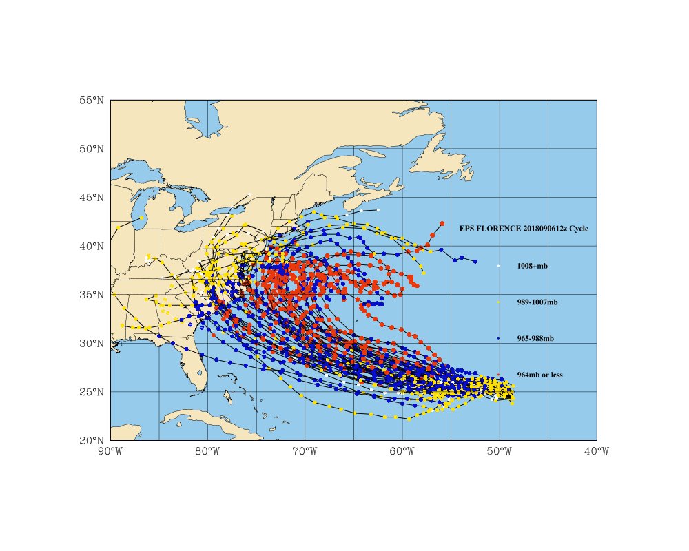
Maybe it's tied to what Webber was just talking about. Might not be wise to call OTS the path we are headed to either as it could be a temporary shift north. We may see it end up on the south side of the guidance in a few days based on that run.Levi makes a great point here. Further update: she is at 22.0N, 45.7W as of 11AM EDT. That means that a whopping 49 of the 51 members are S of the actual track and Flo is, indeed, north of the 0Z EPS mean guidance. So, this means that PERHAPS the 0Z EPS mean track is too far south. At least that’s what Levi is getting at. Hopefully, Flo will continue to track along the northern edge of this guidance. If this continues, maybe future EPS runs will come back north. However, she being on the north side of the guidance may be temporary. So, I’m not actually calling for this at least yet. Just something to follow.
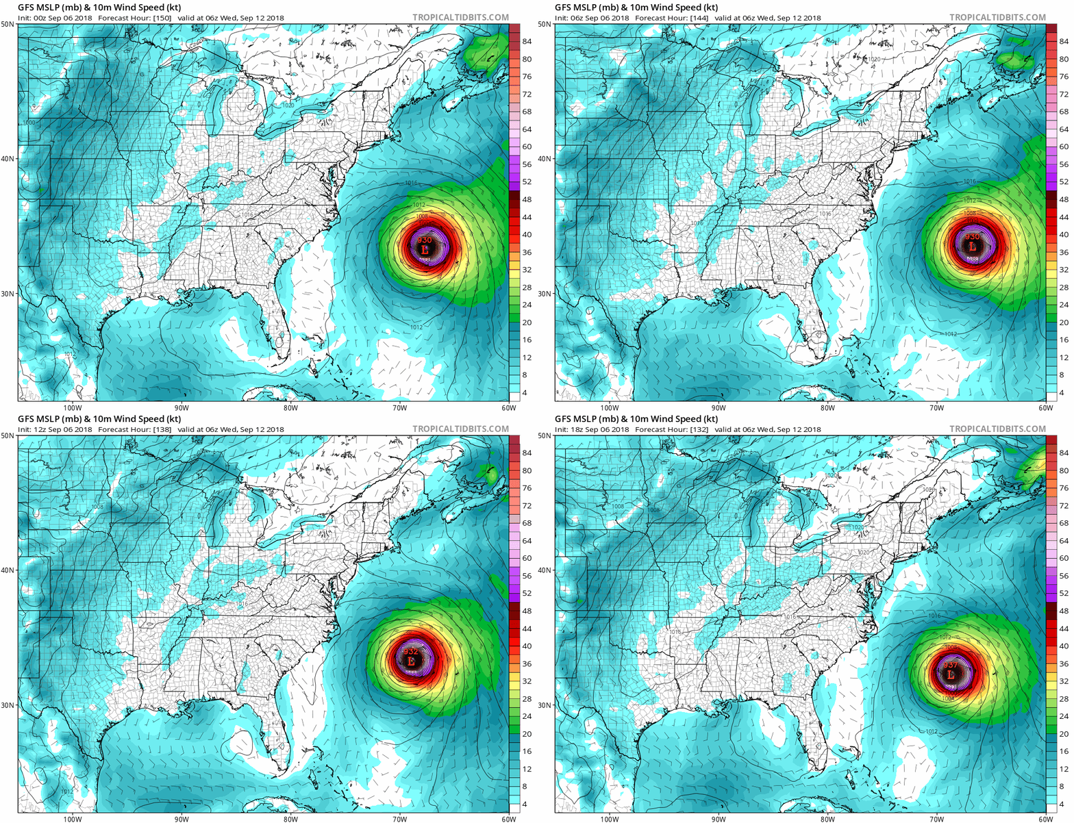
Classic GFS.Anybody notice that Florence gave some portions of the Northeast snow after landfall. That would be pretty crazy. This was on the 6z gfs!
Also a major cool blast to the SE in general. I'm fine with it brushing the coast but the NE will be hit by a major Nor'easter per that run and I'm sure they don't want another hurricane up their way. It happened with Sandy on the snow part so I'm sure it could if that happened.Anybody notice that Florence gave some portions of the Northeast snow after landfall. That would be pretty crazy. This was on the 6z gfs!
If I remember right, it was mentioned last year that stronger hurricanes tend to pull northward on their own. However there are exceptions like ridging. Right now, Florence is pulling north due to a weakening ridge to its north. A new one is expected to build out and prevent it from going north and then weaken again, hence the northward pull again. However, it's the one after that will determine the escape or not.
As far as environmental conditions, it's the size of the storm. Florence is small, and the NHC mentions it found an area of lighter shear and the maps don't show everything correctly in the area. The warm water is what's really fueling development at the moment.
Maybe it's tied to what Webber was just talking about. Might not be wise to call OTS the path we are headed to either as it could be a temporary shift north. We may see it end up on the south side of the guidance in a few days based on that run.