accu35
Member
I guess I shouldn't askNot unless you live in Greenland
Sent from my SM-G955U using Tapatalk
I guess I shouldn't askNot unless you live in Greenland
Sent from my SM-G955U using Tapatalk
Did I mistakenly eat a strange mushroom, or is this in reverse?
Haha sorry. Joking aside it's not an ideal setup to bring cooler weather to the SE. To really an enhance cooler weather in the eastern and southern US we would need a trough picking the system up. In this case we have a ridge building over top. Down the road in 10+ days florence might get captured by a trough and cooler weather be enhanced in the lakes, northeast and maybe mid atlanticI guess I shouldn't ask
Thanks man, I'm just ready for some cooler weather. Aren't we all lol.Haha sorry. Joking aside it's not an ideal setup to bring cooler weather to the SE. To really an enhance cooler weather in the eastern and southern US we would need a trough picking the system up. In this case we have a ridge building over top. Down the road in 10+ days florence might get captured by a trough and cooler weather be enhanced in the lakes, northeast and maybe mid atlantic
Sent from my SM-G955U using Tapatalk
Yep. Gfs got really excited about the trough with the Gordon remnants and dampened the ridge off of the EC and forced it a bit SE this allowed for a recurve even in the face of rapidly rising heights in the eastern USGFS still gonna miss most of the coast it seems, maybe New England?
Just a respectful word or two of heed ... it is the 18z, and for now she's torn apart ... two parts of a multi-part equation that suggest what's on the left of the "=" sign is still being calculated ...GFS actually east of the 12z now lol, misses the coast entirely maybe?

It may be far enough north on the gfs at 174 to get kicked out. If not this run is a slow loop with possibly a second run at the ECGFS actually east of the 12z now lol, misses the coast entirely maybe?
 DT getting practice for winter!!:weenie::weenie:
Like 1991 “perfect storm” boom?Gfs is about to go bombs away in the north atlantic. Strong jet incoming and florence just sitting there
Sent from my SM-G955U using Tapatalk
It actually tied the system up into a front and strings it out. Still a strong system getting into the Canadian maritimes but nothing excessive. The net result of the whole construct and interaction is an omega block over the north Atlantic and a pseudo -nao.Like 1991 “perfect storm” boom?
Need that pseudo -NAO to stay put til mid MarchIt actually tied the system up into a front and strings it out. Still a strong system getting into the Canadian maritimes but nothing excessive. The net result of the whole construct and interaction is an omega block over the north Atlantic and a pseudo -nao.
Sent from my SM-G955U using Tapatalk
 Anybody know this guy?? I hope the effects of his tweets, don’t affect the outcome!
Or his use of improper English grammar ...View attachment 5886 Anybody know this guy?? I hope the effects of his tweets, don’t affect the outcome!
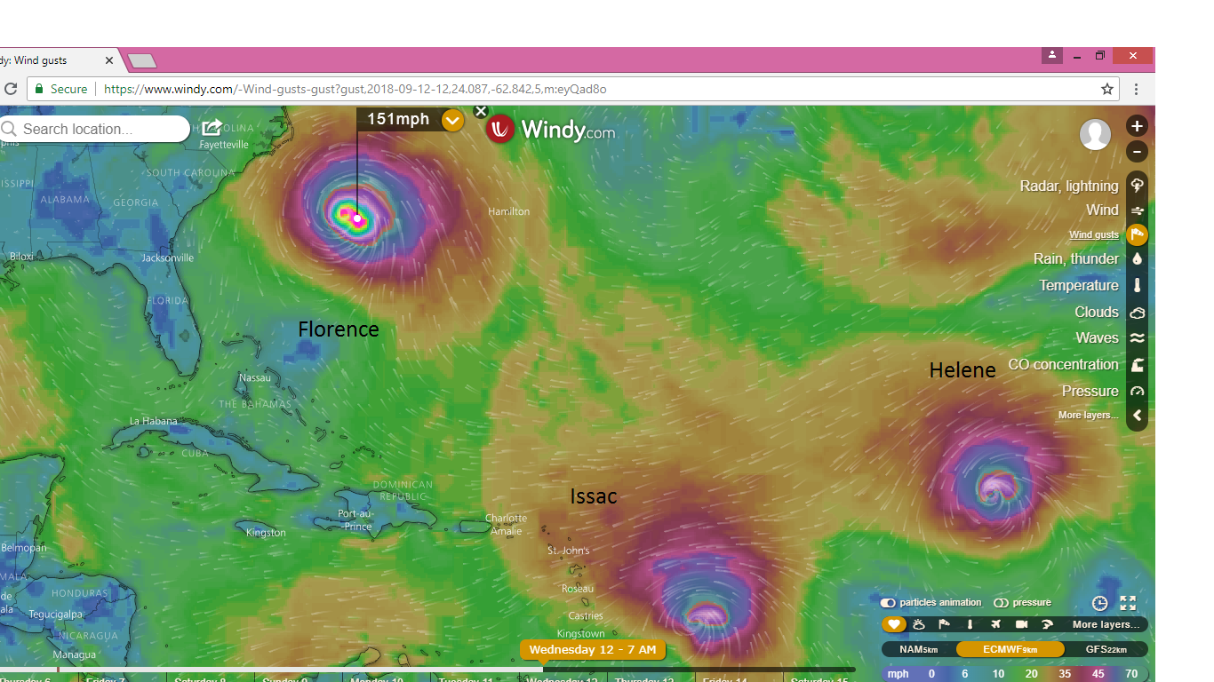
I have never seen this website before, I assume it's legit.... pretty awesome actually, has hi res Euro wind, precip, etc. Interestingscary movie here
 JBs daily Wilkesborodud, MS paint maps!
Take that straight to JAX, if we were only dealing with steering ... but thank God there are other players ...I think this map might have been shared earlier, not sure, but it's obvious her path in the short term..... will not be surprised to a little WSW jog in there as has been mentioned. Not really a lot of good news today overall with Flo
Seems I used to have site bookmarked where you could view the Ukmet ens (mogreps) but I can't find it anywhere.... I know some of you have shared those maps but is there a free site with them?
dadgum quick ... you beat me to it ... good job!
Lol I just found it again.... and thanks!
BTW - It was/is in Wiki ... Experimental Forecast & Ensemble Models (ESRL)dadgum quick ... you beat me to it ... good job!
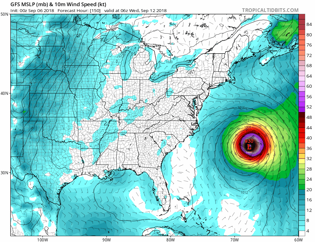
The 0z BEST track is out and Florence has been downgraded to a tropical storm, the 11 o'clock advisory should reflect this.
AL, 06, 2018090700, , BEST, 0, 250N, 498W, 60, 994, TS
Cursing and such diabolic profanity is not allowed ... LOLthat is a decent grouping showing FL. Very Irma like at that.
I know the Ukmet has a south bias but that is a decent grouping showing FL. Very Irma like at that.
Yep for the next 2 days she’s supposed to hover near the 25N area.Based on the 0Z estimated latitude of 25.0W, Flo moved straight westward from 5PM through 8PM EDT. Is that as far north as she’ll get for awhile?
Keep in mind that the 12Z UKMET ensemble initialized 50 miles to the SW of Flo and that all members are currently S of the actual position. Therefore, I expect a further north ensemble mean in the next run. I expect fewer members into FL.