Webberweather53
Meteorologist
70-75 Knot (80-85 mph) gusts reaching well inland over the Carolinas this run... Yikes.
.png")
so, the Euro is showing the opposite of a recurve, and is literally bowing Florence back south and west? Wasn't Hugo always more south in its track than Florence?


 meanwhile almost all the GFS ensembles are out to sea... only 2 hit the US and both in the Carolinas


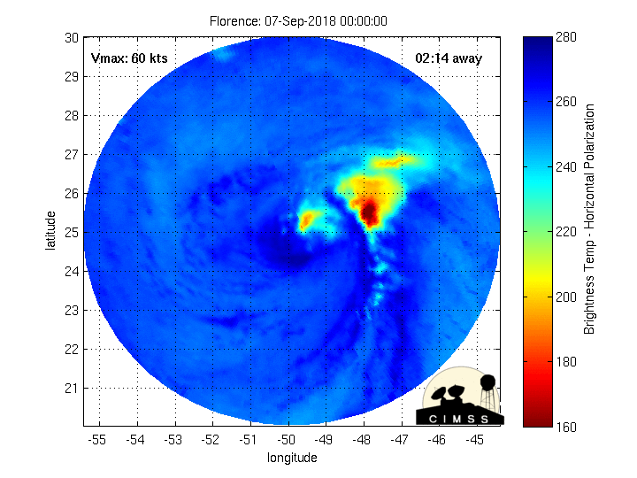
Is it my imagination or is Florence already beginning to restrengthen??
IR loop:
https://www.tropicaltidbits.com/sat/satlooper.php?region=06L&product=ir
Edit: And if so, has she possibly jumped further north?
65-70 here...ouch70-75 Knot (80-85 mph) gusts reaching well inland over the Carolinas this run... Yikes.
View attachment 5904
 Euro ensembles have a pretty tight cluster over NFL and SGA. I think as of now, IMO, that area is most likely ground zero, as the track continues its Southerly shifts
65-70 here...ouch
Sent from my SM-G955U using Tapatalk

View attachment 5910 Euro ensembles have a pretty tight cluster over NFL and SGA. I think as of now, IMO, that area is most likely ground zero, as the track continues its Southerly shifts
Almost looks like 2 camps, one that still trying to stay just off shore and the other starting to key in on Ga/SC... definitely not good trends for the SE.Brand new euro ensembles yikesView attachment 5906
Almost looks like 2 camps, one that still trying to stay just off shore and the other starting to key in on Ga/SC... definitely not good trends for the SE.

Looking at it again, yep, I'll buy that....3 distant tracks are thereLooks like 3 camps to me with ots/sc/ga with central NC in the clear yay
Sent from my iPhone using Tapatalk
I'll get a kiteLooks fun.... *sarcasm*
Sent from my SM-G920V using Tapatalk
I'll get a kite
Sent from my SM-G955U using Tapatalk
I'm just hoping that the Weather Channel sends Jim Cantore to Raleigh. If he runs hurricanes off like he does the snow around here, Florence won't come anywhere near us.Time for a road trip to Raleigh
 This
This

You do realize that there are no islands near this storm and that's a Pacific storm right? Also look at the coordinatesShe's maintaining despite continued significant shear, but the road ahead is primed for explosive development, light shear and look at the SST temps increasing....
at a 144hr+ lead time a lot can and will change, models do not have this nailed down and at this lead time they rarely if ever do.At this point we are about 6 days out from a potential landfall. I expect models will really zero in on things today as the synoptics get nailed down. The overall setup of a stronger ridge is well agreed upon and the biggest difference now is the orientation of the ridging. Honestly, I would lean a blend of Euro/GFS at this point which puts NC at the highest risk. Still plenty of time for things to change but at 5-6 day leads and in this type of setup I don't expect huge changes, just small shifts north/south based on modeled intensity changes.
It's where they send the other guy that matters. If they send him down the coast or up that's where it's going.I'm just hoping that the Weather Channel sends Jim Cantore to Raleigh. If he runs hurricanes off like he does the snow around here, Florence won't come anywhere near us.
Mike Seidel??It's where they send the other guy that matters. If they send him down the coast or up that's where it's going.
I believe so. He seemed to be in ground zero for last year's landfalling systems.Mike Seidel??
What concerns me most about a potential landfall, especially if she heads to NC, is usually our storms are coming from the Bahamas with a NW or NNW motion and weakening due to an approaching shortwave and shear. With the setup for Florence she would be under light to 0 shear with a perfect upper level environment and outflow to strengthen as much as she pleases. In addition the waters off the NC coast are well above normal this year, 29-30C and could in theory support a category 4 hurricane.
at a 144hr+ lead time a lot can and will change, models do not have this nailed down and at this lead time they rarely if ever do.