• Hello, please take a minute to check out our awesome content, contributed by the wonderful members of our community. We hope you'll add your own thoughts and opinions by making a free account!

Tropical Major Hurricane Florence

Good post. If Gordon’s remnants end up stronger than model consensus and track close enough to the NE US at the right time, it COULD increase the odds of Florence recurving safely. I still recall last year when a legit H threat to NC (Maria if I’m not mistaken) steered away due to just the weakening remnants of another TC that was hanging around not too far to the north (Jose I think). Those remnants, though weak, were all that was needed to cause steering to turn Maria away from NC. Anyone recall this?
I agree that Gordon could have an effect on the forecast; however, I do not think it will be nearly as pronounced as Jose was with Maria. Jose was a long-lived tropical storm that sat out in the ocean around the northeast coast, while Gordon will be a significantly weakened low that has already made landfall. I think there will be much larger factors that decide where Florence goes.
 
The crucial latitude to cross before 60W is 30N to very likely avoid the SE US. The 0Z Euro barely did that by moving her west along 30N before moving her WNW. However, the 0Z UKMET has it moving due west way down at 25.2N, the latitude of the far S tip of FL.
icon_eek.gif


HURRICANE FLORENCE ANALYSED POSITION : 20.5N 43.9W

ATCF IDENTIFIER : AL062018

LEAD CENTRAL MAXIMUM WIND
VERIFYING TIME TIME POSITION PRESSURE (MB) SPEED (KNOTS)
-------------- ---- -------- ------------- -------------
0000UTC 05.09.2018 0 20.5N 43.9W 994 53
1200UTC 05.09.2018 12 21.6N 45.7W 998 52
0000UTC 06.09.2018 24 22.6N 47.8W 1001 50
1200UTC 06.09.2018 36 23.6N 49.7W 1004 48
0000UTC 07.09.2018 48 24.2N 51.1W 1005 46
1200UTC 07.09.2018 60 24.4N 52.9W 1005 44
0000UTC 08.09.2018 72 24.3N 54.2W 1003 42
1200UTC 08.09.2018 84 24.2N 55.1W 999 48
0000UTC 09.09.2018 96 24.5N 56.0W 991 55
1200UTC 09.09.2018 108 24.7N 57.4W 985 53
0000UTC 10.09.2018 120 25.1N 59.1W 971 63
1200UTC 10.09.2018 132 25.2N 61.0W 965 70
0000UTC 11.09.2018 144 25.2N 63.1W 963 70

The 12Z UKMET is not backing down at all from its far southern track. As a matter of fact, it is actually nearly one degree further south at the end though it is much weaker with 990 mb vs 963 mb on the 0Z. Its new starting point, 21.6N, 45.5W, is only very slightly adjusted toward reality as at 12Z it was really at 21.7N, 45.2W and was at 22.0N, 45.7W at 15Z. The 12Z UKMET had it at about 21.9N, 45.5W using interpolation...so its 12Z initialization is ~0.3 too far south or about 21 statute miles too far south. It may not seem like much and it may later get closer to reality, but for now it is at least worth noting imo:

HURRICANE FLORENCE ANALYSED POSITION : 21.6N 45.5W

ATCF IDENTIFIER : AL062018

LEAD CENTRAL MAXIMUM WIND
VERIFYING TIME TIME POSITION PRESSURE (MB) SPEED (KNOTS)
-------------- ---- -------- ------------- -------------
1200UTC 05.09.2018 0 21.6N 45.5W 998 49
0000UTC 06.09.2018 12 22.7N 47.6W 1001 55
1200UTC 06.09.2018 24 23.6N 49.7W 1006 44
0000UTC 07.09.2018 36 24.1N 51.5W 1008 40
1200UTC 07.09.2018 48 24.2N 53.4W 1007 37
0000UTC 08.09.2018 60 24.1N 54.8W 1006 35
1200UTC 08.09.2018 72 23.9N 56.2W 1005 36
0000UTC 09.09.2018 84 23.6N 57.2W 1003 40
1200UTC 09.09.2018 96 23.3N 58.4W 1003 39
0000UTC 10.09.2018 108 23.2N 59.5W 1002 41
1200UTC 10.09.2018 120 23.8N 60.7W 999 49

0000UTC 11.09.2018 132 24.4N 63.3W 990 52
1200UTC 11.09.2018 144 24.5N 66.6W 990 50
 
Dumb question, but how do you find the floater images of Florence (or any other storm for that manner)? I used to go to NHC and find them under the satellite section. But now, it just looks like all they have are wide area views. I'm sure I just don't know where to go.
Weathernerds is another good site to use for floaters, you can custom zoom.
https://www.weathernerds.org/
 
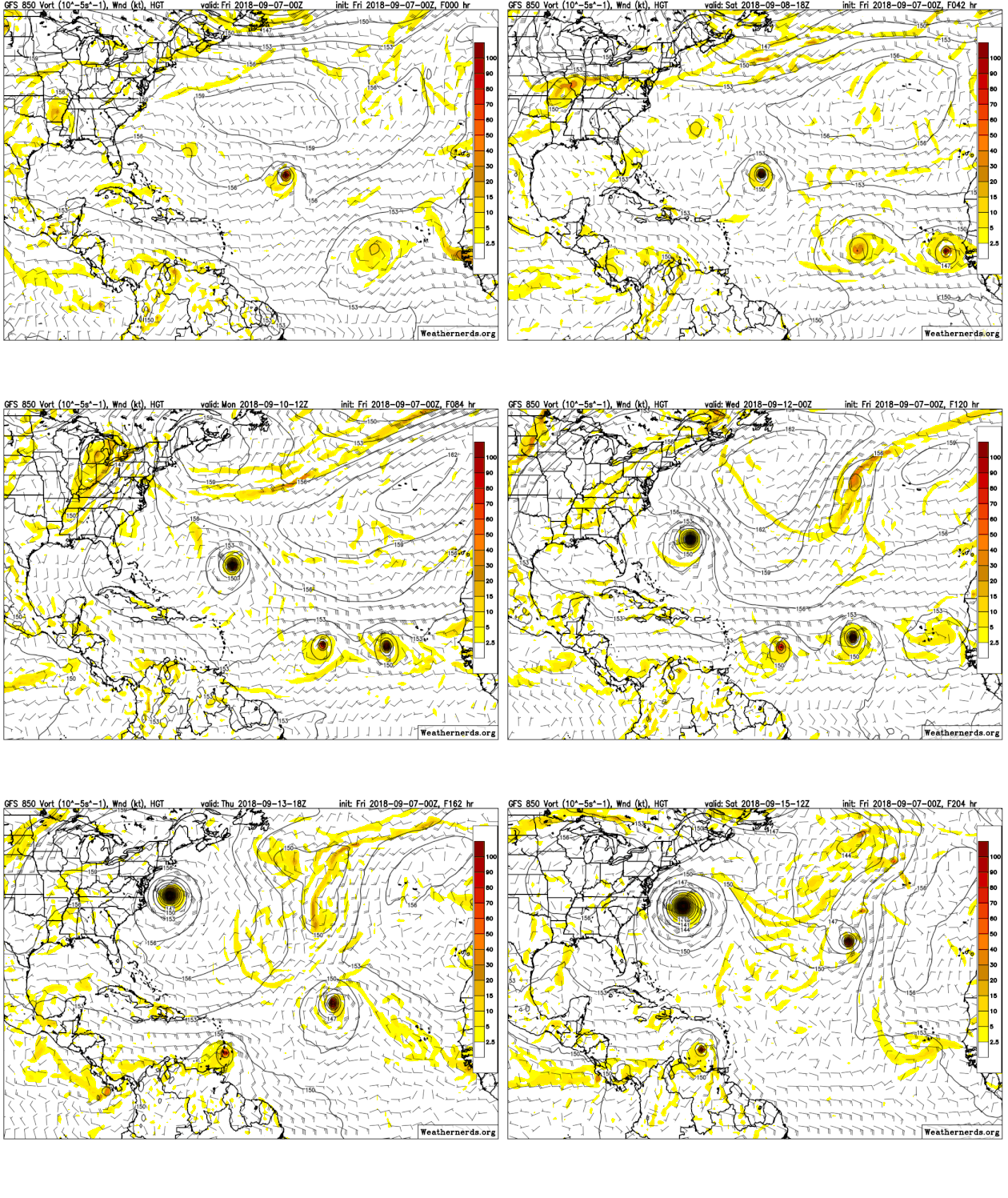
For some early afternoon entertainment, toggle the euro run from 12Z yesterday to 12Z today. One more jump like that and this thing is in the gulf. I think OTS is pretty much off the table now.
 
For some early afternoon entertainment, toggle the euro run from 12Z yesterday to 12Z today. One more jump like that and this thing is in the gulf. I think OTS is pretty much off the table now.
Do it on 2 days and you'll see a nearly identical location to today's run. No way this thing is going south of Miami in any situation. Shoot, no way this thing is going south of Daytona Beach.
 
Last edited:
Sounds like what I said earlier about it being in the middle and not curving north as much.
 
Back
Top