accu35
Member

Looks a good bit stronger as well. Gfs still can’t forecast intensity to save its life it appears.


It’s actually possible. GFS verbatim is forecasting a perfect upper level environment with outflow in all directions and the waters here are about 29C. As long as she’s moving at a good clip a pressure that low is definitely plausible.922 mb near Bermuda ok sure
I could be wrong but I think this run may stay offshore???


NYC incoming on GFS?
Euro has been one of the worst performing models with Florence so far and GFS one of the best. Models tonight aren’t helpful at all with GFS shifting east, cmc west, UK heading for the Bahamas.So looks like we have a CMC, Euro, UK south camp. That’s pretty hard to beat. Recurve is looking less likely.


Uh oh, the 0Z EPS is coming in like the beast of 2 runs ago. More details soon. Or maybe someone who can do it will post the map.

Fwiw, the UKMET (0Z) is still initializing too far SW with 22.7 N, 47.1 W vs the actual at 0Z of 23.1 N, 46.9 W. By the time Flo got to 47.1 W, it was already up near 23.3 N or 0.6 or 42 miles N of where the UKMET had her when it was at 47.1. Maybe it will end up not mattering much but I'd still keep this in mind since it has by far the most southerly track.


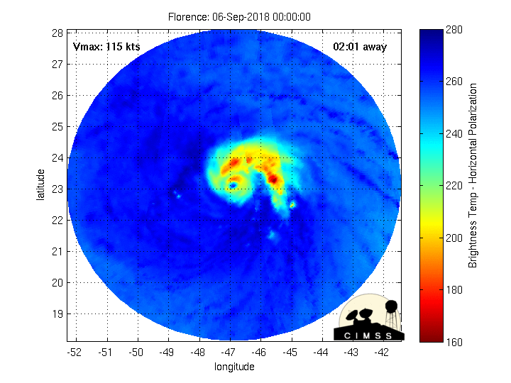
Not to mention the recurve bias and pressure bias. Both cause it to go further north or OTS. We already have 1 factor that could lead to landfall occurring so if we get factor 2 of the ridge building over we are in trouble.My thinking is the GFS has done better up to this point with the intensity and being closest to the track... however I also think it is underestimating the weakening that will occur due to the shear and once this starts a solid westerly motion the GFS may not due as well since it sometimes has a bias of breaking down ridging too soon. The next 36 hours are critical to the future track and how close to the US Florence will get. IMO she is likely a strong cat 1 right now and that's about it. The core is severely weakened and significant dry air intrusion is ongoing per the microwave scan posted above.
If Florence is a weaker storm this would allow stronger ridging to build in to her north whereas a stronger one will break it down and prevent it from building as much (like the GFS shows). Right now based on the weakening trend we are observing I would go with the stronger ridge advocated by the CMC, Euro and UK (although it's probably too strong).The ukmet builds a 597dm ridge to the north which would push it wsw or even sw.
Sent from my iPhone using Tapatalk

If Florence is a weaker storm this would allow stronger ridging to build in to her north whereas a stronger one will break it down and prevent it from building as much (like the GFS shows). Right now based on the weakening trend we are observing I would go with the stronger ridge advocated by the CMC, Euro and UK (although it's probably too strong).
So if it does make it to the coast it would have to stay weak because a strong hurricane would break down the western edge of the ridge and get caught up in the westerlies.


