SWVAwxfan
Member
Severe thunderstorm warning for my area.


But it would be a dry heat.....My garden's done for, I can barely keep it up with 102-103.. View attachment 119182


Yeah, it’s gonna be a heat index day with this rain vs 100 degrees.ha. "undermodeled upstream MCS" is sure one way to break a heatwave. i'll take it today.
My garden's done for, I can barely keep it up with 102-103.. View attachment 119182

But, But....Wow fellas, tonight's GFS run says next week's heat tells this weeks heat to hold his beer... ?


This weather STINKS!

Will probably curb the MCS threat later too.Yeah seems like theres going to be enough convective debris/stratoform remnants to limit the heat potential today had.
While next week looks pretty monstrous it is practical to apply the same skepticism to those temperatures as a board-wide snow @156 or sub-zero lows in january
But ultimately it’s an extreme solution and one should view it in the same way you’d view a 12-24” snowstorm showing up on the models at D7. It could happen, but chances are it’ll be more moderated than that.But, But....
they said the GFS was wrong and it'll moderate.
That's highly unlikely to materialize—ECMWF has been going nuts the past two runs showing 850 mb temps above 80°F.My garden's done for, I can barely keep it up with 102-103.. View attachment 119182


Mesoscale convective systems in the summer are not readily or easily picked up (due to timing issue, subtleties that are very hard to predict or pinpoint, etc.).Pretty bad when a forecast for excessive heat here in the summer busts because of rain the day of the forecast. Heat here in the summer should be the easiest thing to get right less than 24 hours out.
This is true. That being said, I was forecasted a high today of 101 with heat index up to 112. As of right now it’s still just 81 at 12:50pm. With the clouds around, 90 might be pushing, yet both TWC and GSP still has not updated the forecast and is still showing 101. I’ve definitely seen times during the winter when a wedge held in longer than forecast and a forecast of 62 turned into 48, but o don’t think I’ve ever seen a heat forecast be anywhere close to as far off as today appears to be.Mesoscale convective systems in the summer are not readily or easily picked up (due to timing issue, subtleties that are very hard to predict or pinpoint, etc.).
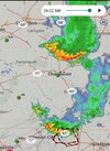
The HRRR still isn't even picking up on the convective system in South Carolina now and still continues to show nothing although the radar is lit up like a Christmas tree currently... A little chaos theory ongoing. One thing goes wrong, it messes up the whole recipe
Indeed. The whole forecast today hinged on the MCS arriving after 18z which would have allowed us to warm to near 100 today. The mcs that models did a poor job in forecasting yesterday over Indiana really screwed up the entire days forecast from temps to precipitation chances. Riding the theta E gradient on the eastern side of a heat ridge is going to lead to massive forcast errors vs being firmly under a vertically stacked death ridgeMesoscale convective systems in the summer are not readily or easily picked up (due to timing issue, subtleties that are very hard to predict or pinpoint, etc.).
The HRRR still isn't even picking up on the convective system in South Carolina now and still continues to show nothing although the radar is lit up like a Christmas tree currently... A little chaos theory ongoing. One thing goes wrong, it messes up the whole recipe