• Hello, please take a minute to check out our awesome content, contributed by the wonderful members of our community. We hope you'll add your own thoughts and opinions by making a free account!

Pattern June 2022

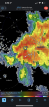
Always love seeing these latter dark, slow moving, summertime storm masses moving in. Can see some of the lightning off in the distance.

Hoping this will hold on further east. Haven’t been to lucky with the pop up storms to start the month.3DC793B5-6056-4B99-8F96-37610888410A.png
 
Well the big heat that's been showing up on the GFS has been on and off a bit but the 18 definitely has it. It get's started for many on the 13th and then the (even) bigger heat comes in about a week later and lasts the duration of the run. Those later frames don't mean much of course but the GFS says we are headed for a big early heat wave for many; at least mid to upper 90s. That would be the kind of weather I dread and loathe. GSP has not hit 100 since July 2016, when it hit exactly 100 once; the same for July 2015. It has not been over 100 since the late June heat wave of 2012 that set the all time records. CLT has not hit 100 since June 2015, when it did so 5 times. I thought CLT hit 100 in the October wave of 2019 but it topped out at 99. I am pretty sure even CAE has not hit 100 the past 2 years, meaning the last time would be Oct 2019; which is a pretty good streak for them.

The 12z Euro has it too, though a notch cooler for the 13th-17th frame, but it only goes out 240, which is prior to when the GFS shows the really big heat. For what it's worth, the CMC is way milder, mostly 80s and a couple of low 90s, but many say the CMC has a cold bias.

On the ensemble side, both the GEFS and EPS show a milder heat with with mainly upper 80s in elevations and north of I40 to low to mid 90s for most others; still hot, but not what the GFS is showing. GEPS is even milder with mostly 80s and a few low to mid 90s.

Right now all the models show heat intensifying in the SE and especially South Central US, but he GFS is by itself with the high 100+heat for an extended period. I am going to say it is likely too hot, maybe significantly so (I just hope it's not on to something!). Gonna get hot in about a week regardless, but hopefully not the big stuff. We'll see.
 
That 00z GFS run does finally "cool down" into the mid 90s by the tail end of the run, as the ridge finally breaks down.
 
Looks like the HRRR with it's usual mixing bias issues this afternoon, showing dews in the low 60s while other models upper 60s to low 70s. It's why it's bone dry around here for today.... really need it to be wrong and need some wide spread t-storm coverage
 
Looks like the HRRR with it's usual mixing bias issues this afternoon, showing dews in the low 60s while other models upper 60s to low 70s. It's why it's bone dry around here for today.... really need it to be wrong and need some wide spread t-storm coverage
The Nam and the Woofs and the Rgem and even the Germans are all much more enthusiastic.
 
90*F+ temps are in Jeopardy today, with that MCS moving in.

The portion moving towards DFW is weakening, *BUT*, not soon enough to avoid at least some outflow influence & cloud debris.
 
The Nam and the Woofs and the Rgem and even the Germans are all much more enthusiastic.

Cons for today: 850's and below aren't the best temp wise. .

Pros for today: 850 and up are awesome and we have some actual shear to work with.

I think the NWP are off on their coverage. I'm gonna go with a 70% we get better coverage than they depict.
 
90*F+ temps are in Jeopardy today, with that MCS moving in.

The portion moving towards DFW is weakening, *BUT*, not soon enough to avoid at least some outflow influence & cloud debris.

Got 89'd before the outflow boundary moved through.
 
Back
Top