BHS1975
Member
You are correct. It's going to the PNW. At least initially.
No I mean way south like last year.
Sent from my iPhone using Tapatalk
You are correct. It's going to the PNW. At least initially.
I'm not so sure we have a good understanding of cliff diving. Cliff diving would be saying winter is over in December. Cliff diving is not having a persistently bad pattern that corresponds to what you would expect to see in a La Nina and having models and ensembles continually migrate back to that look. It's not just one bad model run.Can someone post the latest PNA forecast? Also do we cancel upcoming patterns on ONE model run? I'm kind of confused here on the cliff diving by some here.
Even still, I think we probably still end up around 8-10 above average for Christmas DayLol -NAOs always ruin torches View attachment 98643
Thanks, I appreciate your detailed explanation to get me up to speed with the mood swings today in the board. I agree there isn't much speaking for a colder January at the moment, but I would also argue that we aren't seeing a lot saying torch for the southeast US for the foreseeable future. There is no persistent consistency among the major model suites that all point to above average week after week with no cold shots in between. If the MJO continues its progression along 7 and then lower amplitude toward the COD or 8, I don't see how that would be a bad pattern for the south. I grant that this doesn't mean we get a string of below average days, but I also don't want to shelve any ideas of cool weather in early January for the south. Maybe others can help explain as well.I'm not so sure we have a good understanding of cliff diving. Cliff diving would be saying winter is over in December. Cliff diving is not having a persistently bad pattern that corresponds to what you would expect to see in a La Nina and having models and ensembles continually migrate back to that look. It's not just one bad model run.
If you're really trying to forecast the pattern, I mean honestly and objectively tying to get it right, there is absolutely nothing right now that would move you to forecast a cold or snowy period for the SE for the foreseeable future. That's not being negative. That's making a guess based on all of the data that is currently available.
Now you can speculate that changes in the stratosphere or an eventual MJO propagation or a weakening of La Nina may lead to a better pattern. But that's not a lot better than a coin flip in the face of a stubbornly persistent pattern and virtually all modeling predicting its stickiness. Pretending like that idea is based on one model run and everyone is just being negative and cliff diving is disingenuous and not really objectively looking at all the data right now.
This is Seattle’s winter. Wow they may have record breaking snow this year
Yep, now that’s now that’s super consolidated it’s gonna be hard to boot east and gonna pump heights out ahead way more
That's one of the ugliest things I've seen. The bad part is that's only day 10 around the new year. Thats the range models sometimes start to get a hold on the general pattern. Considering they all look like that gives it more credibility. If that's indeed the pattern we have on New Years that's not something you get out of quickly. The 1st 10 days of January would be done at that point. I'm tired kicking the can down the road every year.-NAO/+SER combo ? Who would have thought View attachment 98651
-NAO/+SER combo ? Who would have thought View attachment 98651
Remmeber back when the - NAO helped to lock the cold air in the east? Now it just seems like the -NAO just keeps us from possible having recording breaking warmth,but not helping with giving us a sustained cold pattern. The strongly -PNA pattern is really hindering our chances of getting a favorable pattern in the SE.-NAO/+SER combo ? Who would have thought View attachment 98651
-NAO/+SER combo ? Who would have thought View attachment 98651
Can someone explain how a ridge pattern is sooo difficult to break but a trough breaks after one day! Jeez this sucks
Thank you Eric. Makes sense. I truly feel like a -PNA the biggest player in this patternI thought this response may be appropriate for the main thread here.
La Nina + West Pacific MJO constructively interfering w/ one another. You get slower-moving, high amplitude planetary waves that are difficult to damp/wash out, which also feed back onto the MJO circulation and slow it down against the -NAO, easterly QBO, and that are attempting to push it out into the W hem (which I thought was more likely in the long-run). I had a feeling tho an unforeseen slow down like this could occur and would delay any pattern change out east (vs what models were showing at the time, which was phase 8 by Dec 20-25) and was hoping/banking on it not being this bad s.t. by the time we entered the New Year, we'd at least have some glances of a decent pattern in early-mid January. Have to admit, my confidence in that scenario is starting to decrease a little the past day or two, but I still feel that's realistically by comparison to the rest of winter (except perhaps March?), our best window overall to see cold/snow prior to February, when have to start working really hard against the grain of unfavorable Feb Nina climo on top of a warmer basic state climate and crappy initial pattern (lots of early winter -PNA) all trying to keep us warmer/drier/less snowy than normal. We can get decent patterns in Nina Februarys, but they are few and far in between.
I think it was @Ollie Williams that posted the Dec 2010-Jan 2011 pattern but I can't find it now. It may have been Webber. Either way it was a west based -NAO and also had an Aleutian ridge and no ridging out west and we still were cold and had snow. I don't get it. I'm going to join @Rain Cold on the dark side and agree this is a very persistent stubborn pattern and it holds on regardless of what the indices say and only breaks when it wants to. We clearly don't understand all the forces at work that drive patterns.
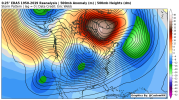
I think it was @Ollie Williams that posted the Dec 2010-Jan 2011 pattern but I can't find it now. It may have been Webber. Either way it was a west based -NAO and also had an Aleutian ridge and no ridging out west and we still were cold and had snow. I don't get it. I'm going to join @Rain Cold on the dark side and agree this is a very persistent stubborn pattern and it holds on regardless of what the indices say and only breaks when it wants to. We clearly don't understand all the forces at work that drive patterns.
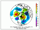
Thank you sir. That's definitely not close to what we have now. We had ridging in western Canada then with energy undercutting it. A thing of beauty. Not sure what time frame I'm thinking of then. There was definitely a composite on here within the last couple days that had a similar pattern to what's modeled now with a different result.
That you fro that is it! I knew I wasn't crazy lol
If anything that ridge is slightly west of where it is now. Maybe that's what we need to root for instead of trying to push it east toward the west coast. Push it west and let the -NAO do work. Without the -NAO you'd definitely want it closer to the west coast though.
Yeo, classic -WPO pattern, not the weird central Aleutian islands ridge, sort of like that CFS run a few days agoIf anything that ridge is slightly west of where it is now. Maybe that's what we need to root for instead of trying to push it east toward the west coast. Push it west and let the -NAO do work. Without the -NAO you'd definitely want it closer to the west coast though.
I don't think it's written in stone anywhere for us not to have a period in January where it gets cold. And I don't mean to indicate that the models are showing an unending torch pattern. They're not. They could be, and that would be bad. The cold could be out of NA completely. That would be bad. But that's not the case either. But in any event, it seems pretty unlikely that we'll slip into a favorable winter pattern for the SE within the next two weeks. Doesn't mean it for sure won't happen. But it would be unwise to consider that the most likely outcome.Thanks, I appreciate your detailed explanation to get me up to speed with the mood swings today in the board. I agree there isn't much speaking for a colder January at the moment, but I would also argue that we aren't seeing a lot saying torch for the southeast US for the foreseeable future. There is no persistent consistency among the major model suites that all point to above average week after week with no cold shots in between. If the MJO continues its progression along 7 and then lower amplitude toward the COD or 8, I don't see how that would be a bad pattern for the south. I grant that this doesn't mean we get a string of below average days, but I also don't want to shelve any ideas of cool weather in early January for the south. Maybe others can help explain as well.
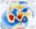
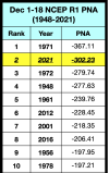
The only good thing about this gefs run is the stronger -NAO, that’s about it, I hope it can stay as long as possible. Because if it breaks down with that pac look, the SER is gonna be relentless View attachment 98664
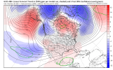
I definitely do not like these 48 hr (8-run) trends over the Pacific.
We have 2 ways to get out of this GOA ridge pattern synoptically. Either:
1) amp the Pacific wave pattern and send the ridge up into Alaska and the Arctic as a strong, high-latitude -EPO, allowing the Pacific jet to undercut and replace the GOA ridge w/ a trough (a better/viable long-term solution but don't have much confidence there)
OR
2) Briefly suppress the GOA ridge with an intrusive NE Russia vortex that moves out into the Bering Sea along w/ extension of the Pacific jet (need more central Pacific convection for that, harder to come by in a La Nina admittedly).
A GOA ridge isn't necessarily the end of the world on its own, we're just in a endless purgatory w/ a slightly amped, quasi-stationary ridge just south of Alaska. Moving it any direction at this point w/ a west-based -NAO would yield a better pattern for us.
View attachment 98665
