coldfront22
Member
Thanks Jack. Hoping less ice more snow. 85/74 always close for both types of precip.


 storm is continuing here but here are the totals with snow still falling according to the RAP. These are overdone but taking 40-50% off these totals and you end up with 2-5" in a lot of places.

I would hazard a guess that Peachtree City may add Forsyth and Cherokee county to the Winter Storm Watch this afternoon. Seems probably we could see 2+ inches of snow in those counties. I’d also bet they throw up a Winter Weather Advisory for right along 20 and everyone else north of 20
It looks like snow, sleet and freezing rain mix to me. Maybe more sleet than anything.Rap has ATL getting crippling ice lolz
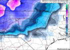
? model
As @griteater reminded us yesterday over on weathernerds it shows ptypeswe hug (remember icon doesn't show mix ptype)
View attachment 105445
I think it is going to much more pronounced than what you are predicting, just my gut feeling.They seemed to have hinted at the advisory level stuff for the I-20 corridor in the SWS they issued this morning. Up to 2 inches (their wording) would be advisory criteria.
At this point, I'm thinking that this will be more of a novelty/nuisance for in-town Atlanta. Just can't see it being anything more than that.
You very well could be right- will be fun to watch either way.I think it is going to much more pronounced than what you are predicting, just my gut feeling.
Thinking Memphis will need to expand their Watch area south if these short term models continue to trend south of the TN/MS border.
Rap has ATL getting crippling ice lolz
model
I think Gwinnett will be today as well.I would hazard a guess that Peachtree City may add Forsyth and Cherokee county to the Winter Storm Watch this afternoon. Seems probably we could see 2+ inches of snow in those counties. I’d also bet they throw up a Winter Weather Advisory for right along 20 and everyone else north of 20

Oooo go ICON!As @griteater reminded us yesterday over on weathernerds it shows ptypes
Weathernerds ICON
www.weathernerds.org
I bet Dekalb and Fulton, possibly Cobb as well.G
I think Gwinnett will be today as well.
No, this is very possible.


I feel like most of north Mississippi will have an advisory, I think this system is definitely a tricky one to forecast, would hate to be in their shoes, but Memphis is normally spot on with their forecast.Thinking Memphis will need to expand their Watch area south if these short term models continue to trend south of the TN/MS border.
Icon 20 inches here?waiting on the ukie Kutchera: 12z Globals
My Fav Icon


Yes, seems to be a slight eastward shift on most of the modeling this morning that is encouraging. We’ll see what happens! Seems the models are converting to a more sensible level SLP track, too (not over central NC through the wedge).
Something to note about the backend possibilities… the GFS has actually done really well in the past of catching onto backside snow when it ends up materializing in the Carolinas. February 2014 and January 2016 both come to mind, and I think December 2018…just something to watchWhile most modeling seems to have a general consensus on amounts, p-type, etc, this like any other storm we track in the south is going to be more than 12 hours and below event. There is just so many small features that some modeling isn't picking up on yet. And still so many unknowns in regards to the strength of the CAD and the low pressure and ULL that could possibly bring in some backend stuff.
No IP mapMet does NBM have a sleet or is sleet the Flat Ice: Figure Flat Ice has to be frzng Rn.


Can you show the source please? Thanks (maps).UKMET blanked ATL
That's around when they will issue the watches etc. 3-4 pm usually for em'. Probably doing the live to explain to people what it means as it's being issued.CAE is doing their Facebook live at 3:30
 model
model