accu35
Member
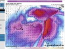
Nope sleet or drizzle. DGZ is bone dryView attachment 104843
Canadian shows sleet at 96 but sounding is snow


That sounding would be freezing drizzle, not snow.View attachment 104843
Canadian shows sleet at 96 but sounding is snow
Tight gradient for metro Atlanta!
UKIE
That sounding would be freezing drizzle, not snow.

I seriously doubt this storm is cutting.Saw this MA thread, while nosing around.
Didn’t high risk post earlier this week that the GFS OP and ensembles are basically run off two different parameters? GFS OP was upgraded but GEFS wasn’t?
Was about to say that....... no saturation in the snow growth zone.That sounding would be freezing drizzle, not snow.
Does this model carry any weight or we just showing it for amusement?
UKIE
I remember when I learned what that was, January 2011. Arggg.The problem with that sounding is there is no moisture where snowflakes form.
Does this model carry any weight or we just showing it for amusement?
It carries a lot. Use to be #2 verification behind euroDoes this model carry any weight or we just showing it for amusement?
The ukmet is a great model.Does this model carry any weight or we just showing it for amusement?
This through end of storm?
UKIE
YesThis through end of storm?
I believe the UK shows just snow like the icon, and Ice/ip/rain the same.This through end of storm?

It carries a lot. Use to be #2 verification behind euro

Fairly certain the GFS ENS were upgraded 1-2 years agoSaw this MA thread, while nosing around.
Didn’t high risk post earlier this week that the GFS OP and ensembles are basically run off two different parameters? GFS OP was upgraded but GEFS wasn’t?
View attachment 104845
Thru 102
But the GFS was upgraded last March.Fairly certain the GFS ENS were upgraded 1-2 years ago
no doubt....temps are close to being big time event over NGAI always look at clown maps with skepticism about it being really just snow. I just checked 0Z UK 850s and sure enough it suggests a good 7” or so of accum of mostly snow near ATL especially just NE of there with some sleet as opposed to this really being ZR because they are colder than 0C most of the precip with warming only to just above 0C near the end of the heaviest.
But the GFS was upgraded last March.
According to Wikipedia (not a given they're right, but is more often than not), maybe you're both right?Oh ok. I think that was the upgrade to increase the vertical levels. No sure if they applied that to the ens or not.